

SubwayStatus
FAIZ SHAUKATALI PRASLA Navigation iPhoneiPadiPod touchApple Watch
SubwayStatus is a free Navigation app for iPhone and iPad by FAIZ SHAUKATALI PRASLA. Requires iOS 17.0. Updated November 11, 2026.
- Price
- Free
- on the App Store
- Size
- 20 MB
- Age 4+
- Updated
- Nov 11
- 2026 · v1.2
Screenshots
Save to Pinterest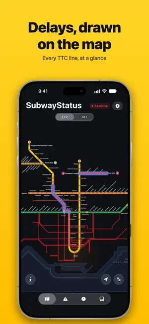


About SubwayStatus
Toronto's transit network, live on one map. SubwayStatus shows TTC and GO Transit service alerts as soon as they're posted, drawn on the exact stretch of line they affect, with the direction and whether shuttle buses are running. LIVE MAP • TTC Lines 1, 2, 4, 5 and 6, plus the GO Transit network and UP Express • Delays and closures highlighted on the stations they affect • Planned weekend and overnight closures in one list ARRIVALS AND BUSES • Next trains at every TTC subway station • GO train departures for any station • Live TTC, GO, York Region Transit and Brampton Transit buses and streetcars, with stop predictions LOCK SCREEN AND HOME SCREEN • Live Activities count down to your next departure, in the Dynamic Island too • A Home Screen widget shows alerts on your lines • Turn on notifications for the lines you ride SUBWAYSTATUS PRO: one-time purchase, no subscription • My Routes: save the legs of your commute • Alerts for your commute: a notification when a disruption lands on one of your legs (with the app closed, alerts cover the whole line) • A widget that follows your routes SubwayStatus is independent and not affiliated with or endorsed by the Toronto Transit Commission, Metrolinx (GO Transit, UP Express), York Region Transit or Brampton Transit. Service information comes from each agency's open data.
What’s new
Version 1.2 · Updated November 11, 2026
New in 1.2 • Streetcars on the subway map: the whole streetcar network, laid out like the official TTC map. Zoom in and the streetcars near you show up live; tap one to see its route, where it's headed and its next stop. Turn them off in Settings › Display. • A cleaner map: Lake Ontario and Lake Simcoe drawn the way the official maps draw them, with waves rolling onto the shore, and station names and line badges placed like the TTC and GO maps. • Smoother pinching and panning, and the map gets ready while the app opens. • Bus detours drawn on the Buses map when the TTC posts one. • Shuttle buses that stop short of a closure are shown only where they run, with a note on the alert card. • On iPad, the Buses panel sits at the bottom and drags between three heights, like Maps. • Clearer map buttons: one for your nearest station, one to see the whole map.
App privacy
The developer, FAIZ SHAUKATALI PRASLA, reported these privacy practices to Apple.
Data Used to Track You
The following data may be used to track you across apps and websites owned by other companies:
- Identifiers: Device ID
Data Linked to You
The following data, which may be collected and linked to your identity, may be used for the following purposes:
- Location: Coarse Location
- Identifiers: Device ID
- Usage Data: Product Interaction, Advertising Data
Used for: Third-Party Advertising, Developer’s Advertising or Marketing, Analytics, App Functionality
Data Not Linked to You
The following data, which may be collected but is not linked to your identity, may be used for the following purposes:
- Diagnostics: Performance Data, Other Diagnostic Data, Crash Data
- Other Data: Other Data Types
Used for: Third-Party Advertising, Developer’s Advertising or Marketing, Analytics, App Functionality
Alternatives to SubwayStatus
Looking for apps like SubwayStatus? Here are 6 similar apps on the App Store. The highest rated is Schoonmaker Tour - NMGL (5.0/5), and all 6 are free to download.
-
 TTC Finder
-
 300ER Shuttle
-
 HallWiz - Tunnel Maps
3.7
-
 Schoonmaker Tour - NMGL
5.0
-
 Toronto Metro Map
-
 Pesos to Dollars: Convert
5.0
| App | Rating | Price | Last updated | Compare |
|---|---|---|---|---|
| SubwayStatus | – | Free | November 11, 2026 | |
| TTC Finder | – | Free | Sep 11, 2026 | Compare |
| 300ER Shuttle | – | Free | Aug 17, 2026 | Compare |
| HallWiz - Tunnel Maps | 3.7 / 5 (3) | Free | Nov 14, 2026 | Compare |
| Schoonmaker Tour - NMGL | 5.0 / 5 (2) | Free | Nov 5, 2026 | Compare |
| Toronto Metro Map | – | Free | Sep 10, 2026 | Compare |
| Pesos to Dollars: Convert | 5.0 / 5 (1) | Free | Aug 19, 2026 | Compare |
Compare SubwayStatus with the top alternatives: ratings, updates, ASO score and keyword gaps →