

What Can Kill Me
Michael Harlow Navigation iPhoneiPadiPod touch
What Can Kill Me is a free Navigation app for iPhone and iPad by Michael Harlow. Rated 5.0/5 from 1 ratings. Requires iOS 15.1. Updated October 18, 2026.
- Rating
- 5.0
- 1 ratings
- Price
- Free
- on the App Store
- Size
- 62 MB
- Age 17+
- Updated
- Oct 18
- 2026 · v1.1.0
Screenshots


About What Can Kill Me
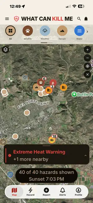
What Can Kill Me shows you the hazards around you before you walk into one. Open the map and you see two things at once: hazards other people have reported, and live warnings from public agencies. A rattlesnake somebody spotted on the trail last week sits on the same map as today's National Weather Service heat advisory and a satellite fire detection three ridges over. WHAT'S ON THE MAP Hazards reported by users across eight families — wildlife, weather, terrain, water, fire, people, infrastructure and plants — each with a severity, an optional photo, and a count of how many others confirmed it National Weather Service alerts NASA FIRMS satellite fire detections National Park Service alerts and closures USGS earthquakes and stream gauges Avalanche forecasts from Avalanche.org member centers iNaturalist species observations WHAT TO DO ABOUT IT Tap a hazard and you get more than a pin. For rattlesnakes, hypothermia, rip currents, ticks, poison oak, lightning, flash floods and thirty more, the app carries sourced guidance from the National Park Service, CDC, Red Cross and state agencies: what to do before, what to do if it happens, and what not to do. REPORT WHAT YOU FIND File a hazard from where you are standing, or point to it on the map from a safe distance. Add a photo, pick a severity, and it is on the map for everyone. Never approach, provoke, touch or feed a hazard to report it. CHECK IN WITH PEOPLE WHO WOULD COME LOOKING Add trusted contacts, then tap I'm Safe or Need Help. The app writes the message — your status, your location, a map link — and hands it to your own Messages app. Nothing is sent until you send it. We never message anyone on your behalf. PLAN AHEAD Alert Places — a circle around a trailhead, a campsite or home, showing new hazards reported inside it, with an optional notification when something new is reported Country Info — local police, ambulance and fire numbers for the country you are in, saved on your phone Trip Packs — an area's hazards and agency phone numbers saved to your phone for where there is no signal Daylight left until sunset, calculated on your phone Your location in every coordinate format, a compass, and bearings on a landmark BUILT TO BE HONEST The map tells you when a data source is unavailable rather than showing an empty area as safe. Somewhere with no pins is somewhere nobody has reported. That distinction is the whole app. ACCESSIBILITY Text size, high contrast colors, light and dark appearance, and VoiceOver throughout. PREMIUM (OPTIONAL) Free is the whole safety app. Every report, every live feed, check-ins, offline caching, reporting and confirming — none of it is behind a wall. Premium adds unlimited Trip Packs and Alert Places instead of one each, alert circles up to 25 miles instead of 5, and the ability to choose which hazard categories each place alerts you about. $4.99/month or $39.99/year. No ads on either plan. Your data is never sold. BEFORE YOU RELY ON THIS You must be 18 or older. This is an information tool, not an emergency service and not a substitute for your own judgment, official warnings, or calling 911. Conditions change faster than reports do. User reports are unverified. Public agency data can be delayed, incomplete or wrong. A hazard report shows where it was filed, and reports filed from "My location" publish where the person was standing. TERMS AND PRIVACY Terms of Use (EULA): https://www.apple.com/legal/internet-services/itunes/dev/stdeula/ Service terms: https://legal.whatcankillmeapp.com/terms.html Privacy Policy: https://legal.whatcankillmeapp.com/privacy.html
What’s new
Version 1.1.0 · Updated October 18, 2026
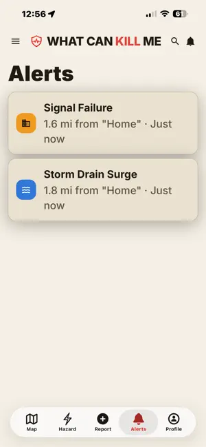
Notifications for your Alert Places. When someone reports a new hazard inside an area you saved, we can notify you — even when the app is closed. You choose, place by place, and you'll be asked only after you save your first Alert Place. Notifications are a convenience, not a warning system: they can arrive late or not at all where there's no signal, and the Alerts tab is always the complete list. Emergency numbers abroad. New Country Info pages carry the local police, ambulance and fire numbers for the country you're standing in, checked against two or more official sources, and work with no connection. Available for a first set of countries, with more to come. Updated Terms of Use and Privacy Policy. Both now describe notifications and what we store to send them. You'll be asked to review and agree once. Fixes: reports filed from a point far from your location now save correctly, and the account-deletion list is complete.
App privacy
The developer, Michael Harlow, reported these privacy practices to Apple.
Data Linked to You
The following data, which may be collected and linked to your identity, may be used for the following purposes:
- Purchases: Purchase History
- Location: Precise Location
- Contact Info: Email Address
- Contacts: Contacts
- User Content: Photos or Videos, Other User Content
- Identifiers: User ID, Device ID
Used for: App Functionality
Alternatives to What Can Kill Me
Looking for apps like What Can Kill Me? Here are 6 similar apps on the App Store. The highest rated is Rego - Bookmark Your Places (4.7/5), and all 6 are free to download.
-
 Trace of Nature
-
 TrailX: Discover New Adventure
-
 Mapcraft: Walk & Explore Map
-
 Tucson Bikes
1.0
-
 Rego - Bookmark Your Places
4.7
-
 Santee Lakes
| App | Rating | Price | Last updated | Compare |
|---|---|---|---|---|
| What Can Kill Me | 5.0 / 5 (1 rating) | Free | October 18, 2026 | |
| Trace of Nature | – | Free | Oct 13, 2026 | Compare |
| TrailX: Discover New Adventure | – | Free | Oct 12, 2026 | Compare |
| Mapcraft: Walk & Explore Map | – | Free | Jul 10, 2026 | Compare |
| Tucson Bikes | 1.0 / 5 (3) | Free | May 1, 2024 | Compare |
| Rego - Bookmark Your Places | 4.7 / 5 (144) | Free | Sep 28, 2026 | Compare |
| Santee Lakes | – | Free | Jun 12, 2026 | Compare |
Compare What Can Kill Me with the top alternatives: ratings, updates, ASO score and keyword gaps →