

GPS TrackMaker
Odilon Ferreira Junior Navigation iPhoneiPadiPod touch
GPS TrackMaker is a free Navigation app for iPhone and iPad by Odilon Ferreira Junior. Requires iOS 17. Updated October 13, 2026.
- Price
- Free
- on the App Store
- Size
- 74 MB
- Age 4+
- Updated
- Oct 13
- 2026 · v2.0
Screenshots


About GPS TrackMaker
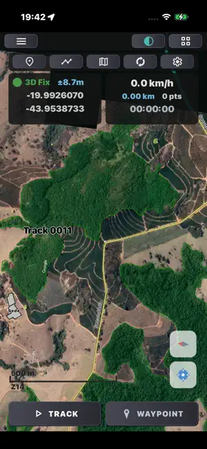
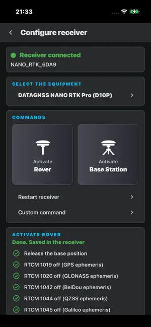
GPS TrackMaker brings to your phone the 25-year tradition of the mapping software used by thousands of GPS professionals and enthusiasts. 100% FUNCTIONAL OFFLINE — NOW FREE Record tracks and mark waypoints for free, with no internet, no sign-up and no subscription. The vector map of your region is stored on the device and works anywhere, even without cell coverage. Export your data as GTZ files and open them in GPS TrackMaker for Desktop. CREATE ON THE DESKTOP, CARRY IN YOUR HAND Draw your maps in GPS TrackMaker Desktop with all the detail you need and send everything to TrackMaker on your phone. Every member of your team carries the complete map in their pocket, even without internet. • AGRIBUSINESS — Draw your farm with crop areas, fences, gates, rivers, streams and headquarters. Outline field plots, mark points of interest and add notes to waypoints. • RURAL COLLECTION AND LOGISTICS — Companies that travel back roads (such as milk collection) create detailed maps of the routes to each farm and distribute them to all drivers. • MINING — Keep the whole operation in your hand: extraction areas, blasting points, roads and side paths, available to everyone working on site. • GOLF — Carry the entire course on your phone: holes, contours, paths and points of interest. FORGET THE TRADITIONAL GPS Replace your dedicated GPS device with the phone already in your pocket. No drivers to install, no cables to connect to the PC: all data is transferred online, simply and directly between the phone and GPS TrackMaker Desktop. OFFLINE VECTOR MAPS Browse maps that combine vector drawing and raster images, rendered sharply at any zoom level. • 100% offline navigation • Names in English, Portuguese and Spanish • Your position always visible on the map GPS DATA COLLECTION — FREE Turn your phone into a complete field data collector, at no cost. • Record high-accuracy tracks, even with the screen off • Mark waypoints with hundreds of icons • Export tracks and waypoints as GTZ files and open them in GPS TrackMaker for Desktop NEW: CENTIMETER ACCURACY (GNSS RTK) A phone's GPS is accurate to a few meters. With a GNSS RTK receiver connected to the phone by Bluetooth, TrackMaker becomes a precision GPS: points and tracks accurate to centimeters. • Online Correction: receive over the internet the data that corrects the position, from public or private servers (NTRIP) • Base Station: use your own receiver as a base and send the correction to the other receivers of your team, with no radio and no computer • Configure compatible receivers from the app: Rover or Base Station mode with one tap • RTK panel: solution type (RTK FIXED, FLOAT, PPP), horizontal and vertical accuracy, satellites and signal • Every waypoint taken in RTK records the solution, the accuracy and the antenna height The app remains free. Online Correction and Base Station require signing in with a GPS TrackMaker PRO account. FEATURES FOR PRO ACCOUNTS GPS TrackMaker PRO account holders can sign in to: • Load on the phone the custom maps (.map) created on the desktop • Sync data online, without cables • Attach audio notes and photos to waypoints • Download multiple base maps • Receive Online Correction to work with centimeter accuracy (RTK) • Transmit as a Base Station for your team PRIVACY FIRST Your data stays on your device. We do not sell your information, show ads or track your usage. Location is only used while you record a track, and data only leaves the device when you sync or use Online Correction or Base Station. Ideal for agribusiness, mining, surveying, environmental work, geology, trails, expeditions and any activity that requires custom maps and reliable geographic records.
What’s new
Version 2.0 · Updated October 13, 2026
NEW: CENTIMETER ACCURACY (GNSS RTK) • External GNSS receiver over Bluetooth as the position source, in the new GNSS menu • Online Correction (NTRIP): receive the correction over the internet from public networks or from your own servers • Configure receiver: Rover or Base Station mode with one tap, plus custom commands • Base Station: use your own receiver as a base and send the correction to your team, with no radio and no computer. Under My base stations, the receivers of the same account receive it • RTK panel: solution (RTK FIXED, FLOAT, PPP), horizontal and vertical accuracy, satellites and signal • Every waypoint taken in RTK records the solution, the accuracy and the antenna height • The internal GPS altitude is now ellipsoidal (WGS84), the same as GNSS receivers. To use sea level, turn on "Record altitudes above sea level" on the GNSS page Online Correction and Base Station require signing in with a GPS TrackMaker PRO account.
App privacy
The developer, Odilon Ferreira Junior, reported these privacy practices to Apple.
Data Linked to You
The following data, which may be collected and linked to your identity, may be used for the following purposes:
- Location: Precise Location
- Contact Info: Email Address
- User Content: Photos or Videos, Audio Data
- Identifiers: Device ID
Used for: App Functionality
Alternatives to GPS TrackMaker
Looking for apps like GPS TrackMaker? Here are 6 similar apps on the App Store. The highest rated is RTKapp (5.0/5), and all 6 are free to download.
-
 Geomx Track
-
 OffLoc - Offline GPS & SOS
-
 Startrace-Satellite Map Marker
-
 Integrity Satellite Monitor
-
 Viação Arte Transportes
-
 RTKapp
5.0
| App | Rating | Price | Last updated | Compare |
|---|---|---|---|---|
| GPS TrackMaker | – | Free | October 13, 2026 | |
| Geomx Track | – | Free | Nov 29, 2025 | Compare |
| OffLoc - Offline GPS & SOS | – | Free | Oct 23, 2026 | Compare |
| Startrace-Satellite Map Marker | – | Free | Jul 2, 2026 | Compare |
| Integrity Satellite Monitor | – | Free | Aug 11, 2026 | Compare |
| Viação Arte Transportes | – | Free | Sep 28, 2026 | Compare |
| RTKapp | 5.0 / 5 (1) | Free | Jun 27, 2026 | Compare |
Compare GPS TrackMaker with the top alternatives: ratings, updates, ASO score and keyword gaps →