

FYRAVUE
Manuel Knakowski Weather iPhoneiPadiPod touch
FYRAVUE is a free Weather app for iPhone and iPad by Manuel Knakowski. Requires iOS 17.0. Updated September 12, 2026.
- Price
- Free
- on the App Store
- Size
- 38 MB
- Age 4+
- Updated
- Sep 12
- 2026 · v1.1
Screenshots


About FYRAVUE
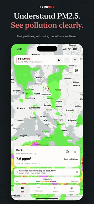
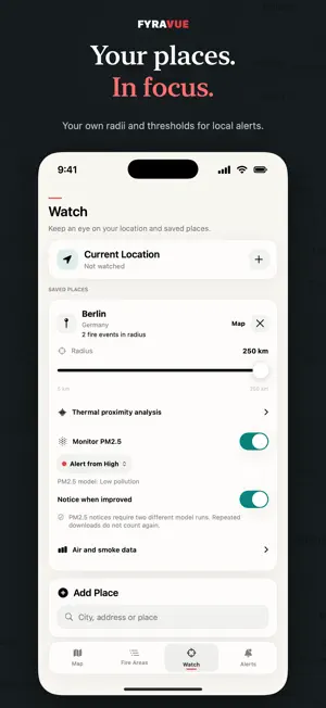
FYRAVUE helps you keep track of satellite-detected fire activity and modeled air and smoke data worldwide. Explore events on the map, save places that matter to you and see how current the displayed data is. What FYRAVUE offers: • Worldwide fire map: Nearby satellite detections are grouped into clear events. Heat intensity, regions and filters help you understand the data. • Satellite view: Explore the surroundings of a fire detection from above. Imagery provides geographic context, may be older and does not necessarily show a visible fire. • Clear air data: PM2.5 pollution, other pollutants and smoke indicators are presented separately, with units, timestamps and information about their model basis. • Your places in focus: Save places or use your current location. Set a radius from 5 to 250 km and choose your own PM2.5 alert thresholds for each place. • Local notifications: Get notices about newly detected thermal activity and confirmed PM2.5 alert levels. Repeated downloads do not count as new confirmation. • Fire data offline: The last valid fire dataset is retained for up to 72 hours. Map tiles and satellite imagery are not included in this offline cache. • Widgets: View fire detections, PM2.5 and smoke AOD for selected places on your Home Screen and Lock Screen. The different measures remain clearly separated. • Focused navigation: Compact map information, favorites, structured fire regions and light and dark map styles. Understanding air data Low PM2.5 pollution means less modeled fine-particle pollution, not low air quality. The PM2.5 rating is not an overall assessment of all air pollutants. Smoke AOD describes the optical thickness of the atmospheric column, not the air you breathe at ground level. Missing or outdated values are identified. Notifications in context Analysis of watched places and notifications run locally. iOS controls background and widget updates; fixed check intervals and real-time alerts are not guaranteed. Missing or disappearing satellite detections do not confirm that an area is fire-free or that a fire has been extinguished. Data sources and limitations FYRAVUE uses NASA LANCE FIRMS data and modeled atmospheric data from the Copernicus Atmosphere Monitoring Service. Thermal anomalies are not individually confirmed fires. Satellite and model data may be delayed, incomplete or inaccurate. The app is not an official warning, health or evacuation system. Always follow local authorities in an emergency. No account required. Location and notification permissions are optional. The app contains banner advertising; the map view remains ad-free.
What’s new
Version 1.1 · Updated September 12, 2026
• Previously loaded fire data is now available offline for up to 72 hours. • Clearer presentation of PM2.5 pollution, other pollutants and smoke indicators. • Improved information on units, data age and model sources. Missing or outdated values are identified more clearly. • Updated Home Screen and Lock Screen widgets with timestamps and consistent ratings across the map, place details and widgets. • Improved local notifications with safeguards against duplicate or misleading alerts after repeated downloads, returning online or changing watch settings. • More compact map information leaves more room for the map. • Easier search and keyboard handling: tap outside the search field or scroll to dismiss the keyboard. • Optimized banner ads with improved spacing. Banners are hidden while typing, and the map view remains ad-free.
App privacy
The developer, Manuel Knakowski, reported these privacy practices to Apple.
Data Used to Track You
The following data may be used to track you across apps and websites owned by other companies:
- Identifiers: Device ID
Data Linked to You
The following data, which may be collected and linked to your identity, may be used for the following purposes:
- Location: Coarse Location
- Identifiers: Device ID
- Usage Data: Product Interaction, Advertising Data
Used for: Third-Party Advertising, Developer’s Advertising or Marketing, Analytics, App Functionality
Data Not Linked to You
The following data, which may be collected but is not linked to your identity, may be used for the following purposes:
- Diagnostics: Performance Data, Other Diagnostic Data, Crash Data
- Location: Precise Location
Used for: Third-Party Advertising, Developer’s Advertising or Marketing, Analytics, App Functionality
Alternatives to FYRAVUE
Looking for apps like FYRAVUE? Here are 6 similar apps on the App Store. The highest rated is My Airport Weather (5.0/5), and all 6 are free to download.
-
 Rockets: Launch Tracker
-
 Barometer on‑Wrist
-
 HailScout: Hail Alerts
4.8
HailScout: Hail Alerts
4.8
-
 Real-Time Lightning by MesoSky
4.9
Real-Time Lightning by MesoSky
4.9
-
 My Airport Weather
5.0
My Airport Weather
5.0
-
 Weather: it is nice outside +
4.4
Weather: it is nice outside +
4.4
| App | Rating | Price | Last updated |
|---|---|---|---|
| FYRAVUE | – | Free | September 12, 2026 |
| Rockets: Launch Tracker | – | Free | Aug 9, 2026 |
| Barometer on‑Wrist | – | Free | Sep 9, 2026 |
| HailScout: Hail Alerts | 4.8 / 5 (25) | Free | Jul 24, 2026 |
| Real-Time Lightning by MesoSky | 4.9 / 5 (11) | Free | Jul 17, 2026 |
| My Airport Weather | 5.0 / 5 (2) | Free | Aug 20, 2026 |
| Weather: it is nice outside + | 4.4 / 5 (79) | Free | Jan 16, 2025 |