

Merestone: SSSI & Habitat Map
LEON NELIO FIGUEIRA Reference iPhoneiPadiPod touchMacApple Watch
Merestone: SSSI & Habitat Map is a free Reference app for iPhone and iPad by LEON NELIO FIGUEIRA. Requires iOS 17.0. Updated October 18, 2026.
- Price
- Free
- on the App Store
- Size
- 66 MB
- Age 4+
- Updated
- Oct 18
- 2026 · v2.10.0
Screenshots



About Merestone: SSSI & Habitat Map
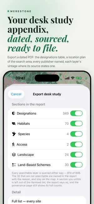
Merestone runs the designated sites search of a desk study and writes the appendix: drop a pin, set a radius, get a dated PDF with results by distance. Not a survey, not a LERC search. United Kingdom · Ireland · France · Belgium · Netherlands · Germany · Switzerland · Austria · Luxembourg · Italy · Spain · Portugal · Norway · Sweden · Poland · Finland · Denmark · Canada · United States · Australia · New Zealand ON THE MAP, UK • SSSI, with unit condition and Impact Risk Zones in England • SAC, SPA, Ramsar, ASSI, nature reserves, National Parks, AONB, National Scenic Areas, CRoW access land • Ancient woodland; priority habitats in England and Northern Ireland; Phase 1 in Wales • Scheduled monuments, listed buildings, parks and gardens, World Heritage Sites, battlefields outside Wales • Flood Zones 2 and 3 in England and Wales, SEPA flood likelihood in Scotland • Coastal erosion, nutrient neutrality, LNRS and the BNG register in England; ALC • Green Belt, TPOs, brownfield land and English conservation areas are partial: empty is never proof of absence IRELAND SAC, SPA, NHA and pNHA, parks and reserves, Ramsar, water, geology, archaeology, townlands and trails. MyPlan zoning complements the adopted development plan; it does not replace it. OPW national flood maps and GSI groundwater flood maps remain excluded pending permission. SEARCH AND PDF Search eligible layers from 250 m to 20 km, by distance to the nearest edge. OS National Grid in Great Britain; ITM in Northern Ireland and Ireland. The PDF lists records with distance, direction, source and available source date, then empty, failed, incomplete or excluded layers and why. Download eligible layers before fieldwork; reports identify downloaded data. Map-image layers cannot be downloaded or listed by radius. EUROPE Luxembourg's PAG layers remain locked while their licence is clarified. Denmark · 39 layers Free: Natura 2000 and Ramsar sites, national parks, fredninger, nature and wildlife reserves. Paid: § 3 nature, beach and dune protection, lake, river, forest and church building lines, zone map, coastal zone, adopted local plans, flood extent in risk areas, scheduled ancient monuments, groundwater protection. ETRS89 / UTM 32N. All Danish layers can be downloaded for offline use. No species records. Canada · 140 layers Federal protected and conserved areas and critical habitat in all 13 provinces and territories, plus regional provincial and territorial layers, which do not replace provincial and local checks. Grid references approximate NAD83 from WGS84. United States · 20 layers, Australia · 14 layers, New Zealand · 17 layers. Coverage varies by source. Eligible layers can now be downloaded for offline use. SPECIES RECORDS Open-licence GBIF observations, CC0 and CC BY only, at most 300 per view: a first look, never an inventory or evidence of absence. They are not in the radius search or PDF and cannot be downloaded. BUYING Merestone Worldwide is a subscription to every country, including any added later. A free 7-day gift unlocks every country once, with no renewal and nothing to cancel. Single countries and bundles can also be bought once in the app. Purchases cover iPhone, iPad, Mac and Watch. An optional account links purchases to merestonemaps.com. Free: the UK statutory core and a starter selection elsewhere, with a 250 m search. PDF export, the wider radius and eligible offline downloads require a purchase or subscription. Swiss layers and Canadian layers outside British Columbia work online only. DATA AND LIMITS Public records are incomplete and may withhold sensitive species. Not included: Local Wildlife Sites, Northern Ireland flood mapping, public rights of way, Scottish Core Paths or BGS geology. Confirm the official record before professional reliance. TERMS OF USE https://www.apple.com/legal/internet-services/itunes/dev/stdeula/ Privacy policy: https://leonfigueira.github.io/fieldmark-site/privacy.html
What’s new
Version 2.10.0 · Updated October 18, 2026
Denmark · 39 layers, with a Danish interface and Danish reports. Offline downloads for the United States, Australia and New Zealand: eligible layers can now be saved for fieldwork. Offline fixes for every country: • Very large areas no longer disappear offline when the map is zoomed into their middle. • Offline reports no longer say a layer could not be checked when nothing is nearby. • Large download plans no longer stall at the start.
App privacy
The developer, LEON NELIO FIGUEIRA, reported these privacy practices to Apple.
Data Linked to You
The following data, which may be collected and linked to your identity, may be used for the following purposes:
- Purchases: Purchase History
- Contact Info: Email Address
- Identifiers: User ID
Used for: App Functionality
Alternatives to Merestone: SSSI & Habitat Map
Looking for apps like Merestone: SSSI & Habitat Map? Here are 6 similar apps on the App Store. The highest rated is TuMarea (5.0/5), and 5 of the 6 are free to download.
-
 Colégio Valsassina
-
 Learn music theory with Sonid
4.7
-
 Warwick District Council
-
 TuMarea
5.0
-
 DfT Know Your Traffic Signs
-
 10 Games: Daily Brain Training
4.7
| App | Rating | Price | Last updated | Compare |
|---|---|---|---|---|
| Merestone: SSSI & Habitat Map | – | Free | October 18, 2026 | |
| Colégio Valsassina | – | Free | Oct 6, 2026 | Compare |
| Learn music theory with Sonid | 4.7 / 5 (215) | Free | Oct 15, 2026 | Compare |
| Warwick District Council | – | Free | Apr 19, 2024 | Compare |
| TuMarea | 5.0 / 5 (1) | Free | Dec 21, 2025 | Compare |
| DfT Know Your Traffic Signs | – | 2.99 USD | Sep 7, 2025 | Compare |
| 10 Games: Daily Brain Training | 4.7 / 5 (56) | Free | Oct 13, 2026 | Compare |