

BridgeWise Norfolk Broads
Coryl Ltd. Navigation iPhoneiPadiPod touch
BridgeWise Norfolk Broads is a free Navigation app for iPhone and iPad by Coryl Ltd. Requires iOS 18.0. Updated August 20, 2026.
- Price
- Free
- on the App Store
- Size
- 11 MB
- Age 4+
- Updated
- Aug 20
- 2026 · v1.0.1
Screenshots


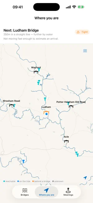

About BridgeWise Norfolk Broads
BridgeWise answers one question for anyone boating on the Norfolk Broads: can my boat get under that bridge, and if not, when? It is not a tide table. It compares your boat's air draft against the predicted water level at each bridge, shows you the arithmetic behind every answer, and tells you plainly when it does not know. WHAT IT DOES • Clearance at Ludham, Wroxham, Acle and Beccles bridges, updated from live Environment Agency gauge readings • Passage windows where the tide genuinely opens and closes a bridge, and current clearance plus a weekly trend where it does not — the upper rivers barely move with the tide, and the app says so rather than pretending • The Great Yarmouth crossing, timed on slack water, showing what waiting for calmer water costs you in headroom • Moorings, with whether you can actually reach them right now and which bridge is in the way • A chart drawn on your phone, so it still works when the signal does not • Reminders to re-check as a window approaches WHAT IT WILL NOT DO It never says a passage is safe. The gauge board at the bridge is the authority and the app tells you to go and look at it. At Potter Heigham it gives you the bridge pilot's number instead of a verdict, because that is the correct answer there. At Great Yarmouth it gives you a time to aim for rather than a yes, because the tidal stream decides there and nobody publishes it. Every verdict carries a safety margin built from named parts — how sure you are of your own air draft, how far the nearest gauge is, how old the reading is — and shows you which part dominates. HONEST LIMITS • Advisory only. Not a navigation chart: no depths, no channel markers, no hazards. • Bridge soffit heights start from published figures and improve as boaters record gauge board readings. • Tidal streams are not modelled anywhere. No open data publishes them for the Broads. • Covers the Norfolk Broads only. Water level data from the Environment Agency under the Open Government Licence. Map data from OpenStreetMap contributors under the ODbL.
What’s new
Version 1.0.1 · Updated August 20, 2026
The Bridges tab now works out which bridge you are coming to, moves it to the top of the list, and shows the distance and the clearance for your own boat. It says "Next" when you are under way and "Nearest" when you are moored, because the closest bridge to a moored boat is often the one you have just come under. It opens with a "Start here" card too, explaining what an air draft is — the height of your boat above the water, printed on your hire paperwork — and why the app will not say whether you fit until you have given one. Nothing new asks for your location, and setting your boat for the first time no longer needs two taps on Done.
App privacy
The developer, Coryl Ltd., reported these privacy practices to Apple.
Data Not Collected
The developer does not collect any data from this app.
Alternatives to BridgeWise Norfolk Broads
Looking for apps like BridgeWise Norfolk Broads? Here are 6 similar apps on the App Store.
-
 Riverways
-
 The Tranquil Otter
-
 Camí de Cavalls
-
 Visit The Broads
-
 Waterways Holidays
-
 Richardson's Boating Holidays
| App | Rating | Price | Last updated | Compare |
|---|---|---|---|---|
| BridgeWise Norfolk Broads | – | Free | August 20, 2026 | |
| Riverways | – | Free | Oct 21, 2026 | Compare |
| The Tranquil Otter | – | Free | Mar 25, 2025 | Compare |
| Camí de Cavalls | – | Free | Oct 27, 2026 | Compare |
| Visit The Broads | – | Free | Jun 26, 2026 | Compare |
| Waterways Holidays | – | Free | Jul 9, 2026 | Compare |
| Richardson's Boating Holidays | – | Free | Jun 26, 2026 | Compare |