

FlyOverhead EFB
FlyOverhead Inc. Navigation iPhoneiPadiPod touch
FlyOverhead EFB is a free Navigation app for iPhone and iPad by FlyOverhead Inc. Rated 5.0/5 from 2 ratings. Requires iOS 15.0. Updated October 5, 2026.
- Rating
- 5.0
- 2 ratings
- Price
- Free
- on the App Store
- Size
- 62 MB
- Age 4+
- Updated
- Oct 5
- 2026 · v1.0.11
Screenshots



About FlyOverhead EFB
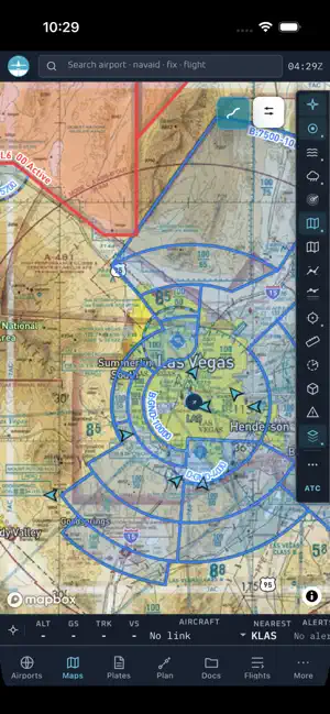
Fly Overhead is an electronic flight bag (EFB) for general aviation pilots. FAA charts, aviation weather, live ADS-B traffic, VFR and IFR flight planning, and a digital logbook in one app. Start free with the live traffic map. Add the EFB when you want to plan, brief, fly, and debrief. FREE 15-DAY TRIAL Every EFB Pro feature for 15 days. No card, nothing to cancel. FAA CHARTS AND PLATES - VFR sectional, terminal area (TAC), IFR low and high enroute - Instrument approach plates, SIDs and STARs - Georeferenced plates: your position drawn on the approach chart - Airport diagrams, runways, frequencies, fuel, field elevation - Six chart products on one continuous projection, on the FAA 28-day cycle - Download charts for offline use AVIATION WEATHER - METARs, TAFs, AIRMETs, SIGMETs, PIREPs - Animated NEXRAD and MRMS radar with recent history up to 2 min resolution - Winds aloft by altitude and inferred turbulence - 3D clouds and 3D terrain - Plain-language decoding of raw METARs FLIGHT PLANNING AND NAV LOG - Leg-by-leg nav log: distance, true course, TAS, ground speed, ETE, fuel burn - Density altitude at departure from the current METAR - Best cruise altitude ranked by head and tailwind component - Crosswind components and VFR/IFR hemispheric rule check - Fuel margin against your aircraft range and reserves - Weight and balance with envelope check - Auto-route that prefers airways and avoids special-use airspace, terrain, and obstacles - Aircraft profiles and personal minimums you set once AIRSPACE AND HAZARDS - Class B, C, D, E and special-use airspace in 2D and 3D - TFRs, NOTAMs, obstacles - Navaids, airways, and fixes as separate layers - Glide range ring, distance and bearing ruler, clearance scratchpad LIVE ADS-B TRAFFIC AND ATC - Live traffic on the same map as your charts and route - Traffic heatmap, aircraft trails, filed IFR route overlay - Live ATC transcription of supported tower, ground, and approach audio, with callsigns linked to traffic where data allows RIGHTSEAT AI BRIEF RightSeat drafts a structured preflight brief from your route, aircraft profile, winds aloft, terrain, NOTAMs, TFRs, and saved minimums. Every frequency and NOTAM number it quotes is checked against the source data first. It surfaces what to look at. You make the call. LOGBOOK, CURRENCY, AND DEBRIEF - Flights detected from your saved tail numbers and drafted into entries - Currency for day and night passenger carrying, IFR, flight review, medical, IPC, and tailwheel - Record a voice debrief at shutdown and it becomes a structured entry - Replay any flight in 3D over terrain - Import from ForeFlight or MyFlightbook; export CSV, GPX, or KML FOR TRAINING Digital CFI endorsements, ACS maneuver grading, checkride readiness against certificate requirements, and instructor and student sharing. Flight school plans add fleet and cohort views. ONE ACCOUNT, EVERY DEVICE Any phone, tablet or browser. No per-device license. PLANS Live traffic map: free, no account EFB Basic, $7.99/mo or $79/yr: full chart set, short AI brief, weather, radar, airspace, TFRs, NOTAMs, VFR sectionals, logbook and currency EFB Pro, $13.99/mo or $139/yr: all of EFB Basic, full RightSeat brief, voice debrief, 3D debrief, filed-route overlay, 3D terrain and airspace Flight School: contact sales Subscriptions renew automatically at the displayed price until canceled. Terms: flyoverhead.com/legal/terms Privacy: flyoverhead.com/legal/privacy IMPORTANT Fly Overhead provides advisory and supplemental information only. It is not approved for navigation. Always verify charts, procedures, weather, NOTAMs, and route information against official sources. The pilot in command retains final responsibility. Terms of Use (EULA): https://www.apple.com/legal/internet-services/itunes/dev/stdeula/ Terms of Service: https://flyoverhead.com/legal/terms Privacy Policy: https://flyoverhead.com/legal/privacy
What’s new
Version 1.0.11 · Updated October 5, 2026
- Easier flight-plan waypoint editing on phones and tablets. - Improved offline chart startup and access. - More consistent live aircraft routes and flight identity. - Updated turbulence forecast controls and freshness checks. - Faster route, weather, and debrief lookups. - Improved logbook auto-import, mobile layout, and pilot help.
App privacy
The developer, FlyOverhead Inc., reported these privacy practices to Apple.
Data Linked to You
The following data, which may be collected and linked to your identity, may be used for the following purposes:
- Contact Info: Email Address, Name
- Purchases: Purchase History
- Location: Precise Location
- User Content: Other User Content
- Identifiers: User ID
Used for: Product Personalization, App Functionality
Data Not Linked to You
The following data, which may be collected but is not linked to your identity, may be used for the following purposes:
- Usage Data: Product Interaction
Used for: Analytics