

Stereogram Go
Sigma Geoscience LLC Productivity iPhoneiPadiPod touch
Stereogram Go is a free Productivity app for iPhone and iPad by Sigma Geoscience LLC. Rated 5.0/5 from 3 ratings. Requires iOS 15.1.
- Rating
- 5.0
- 3 ratings
- Price
- Free
- on the App Store
- Size
- 33 MB
- Age 4+
- Updated
- Oct 30
- 2026 · v1.0
Screenshots


About Stereogram Go
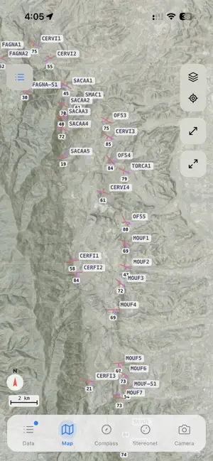
Stereogram Go is a structural geology field app for iPhone. It measures strike and dip with the phone's sensors, plots your data on a stereonet as you collect it, and keeps your stations, photos and notes together in one place. COMPASS AND CLINOMETER Measure planes (bedding, foliation, faults, joints) and lines (fold axes, mineral lineations, slickenlines) using the magnetometer and accelerometer. Heading is tilt-compensated. The app warns you about magnetic interference and locks the reading once the phone is steady. Record in strike and dip (right-hand rule), dip and dip direction, or quadrant notation. For faults, paired mode records the plane and its slickenline together. You can add slip sense (normal, reverse, sinistral, dextral or oblique), rake, formation and your own fields. After saving a measurement you can go straight to the camera to photograph the outcrop. STEREONET AND ROSE DIAGRAM Plot measurements on an equal-area lower hemisphere stereonet (Schmidt net) in the field. Show poles, great circles and slip arrows, and add a Fisher mean with its confidence cone, a best-fit plane or plane intersections. The rose diagram shows strike distribution. Each dataset has its own color and symbol, and tapping a dataset in the legend hides it. FIELD MAP Stations appear on the map with standard geological symbols: strike and dip symbols rotated to the measured strike, lineation arrows, and clusters when zoomed out. There are four base maps: OpenTopoMap, USGS Topo, satellite imagery and hillshade. You can stack them, reorder them and set the opacity of each. You can also import a GeoTIFF of your own geological map as an overlay. WORKS OFFLINE Measuring, plotting and mapping all work without cell service. Your data is stored on the phone. Map tiles are cached as you browse, and you can download whole areas before a trip. Changes sync once you have a connection again. PHOTOS Photos are tagged with GPS coordinates and linked to a station or measurement. You can draw and add text labels on them, with undo and redo. VOICE NOTES Dictate observations from the compass screen while you measure, without typing on the outcrop. ORGANIZING DATA Data is organized into projects, sites, stations and measurements. Datasets have their own colors, symbols and feature codes. You can filter by type, dataset or site, and search everything. Custom fields can be text, numbers or categories, and each category can have its own color. Station names can use a prefix and zero-padding so numbering stays consistent. Export a project to Stereogram Pro on the web for further analysis. Auto-backup can also keep the two most recent copies of your data on the phone.
App privacy
The developer, Sigma Geoscience LLC, reported these privacy practices to Apple.
Data Linked to You
The following data, which may be collected and linked to your identity, may be used for the following purposes:
- Identifiers: User ID
- Usage Data: Product Interaction
- Location: Precise Location
- Contact Info: Email Address, Name
- User Content: Photos or Videos, Other User Content
- Diagnostics: Crash Data
Used for: Analytics, App Functionality
Alternatives to Stereogram Go
Looking for apps like Stereogram Go? Here are 6 similar apps on the App Store. The highest rated is Pointscape: Point Cloud Viewer (5.0/5), and all 6 are free to download.
-
 Outcrop360
-
 Lithos
-
 Pointscape: Point Cloud Viewer
5.0
-
 GEO5 Data Collector
5.0
-
 GeoKit: Field Data Collector
2.5
-
 GeoLibre
5.0
| App | Rating | Price | Last updated | Compare |
|---|---|---|---|---|
| Stereogram Go | 5.0 / 5 (3 ratings) | Free | October 30, 2026 | |
| Outcrop360 | – | Free | Nov 10, 2026 | Compare |
| Lithos | – | Free | Nov 2, 2026 | Compare |
| Pointscape: Point Cloud Viewer | 5.0 / 5 (2) | Free | Nov 19, 2026 | Compare |
| GEO5 Data Collector | 5.0 / 5 (1) | Free | Nov 5, 2025 | Compare |
| GeoKit: Field Data Collector | 2.5 / 5 (2) | Free | Aug 11, 2026 | Compare |
| GeoLibre | 5.0 / 5 (6) | Free | Nov 15, 2026 | Compare |
Compare Stereogram Go with the top alternatives: ratings, updates, ASO score and keyword gaps →