

viaTopo: Swiss Hiking Map
Mischa Richli Utilities iPhoneiPadiPod touch
viaTopo: Swiss Hiking Map is a free Utilities app for iPhone and iPad by Mischa Richli. Requires iOS 15.0. Updated October 10, 2026.
- Price
- Free
- on the App Store
- Size
- 33 MB
- Age 4+
- Updated
- Oct 10
- 2026 · v1.1.12
Screenshots



About viaTopo: Swiss Hiking Map
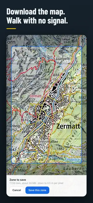
viaTopo plans a hike on the official Swiss national map, and takes it with you. Tap your waypoints and viaTopo works out the path between them from the federal topographic model, so the line takes the switchbacks of the real trail instead of cutting straight across the slope. It reports the distance, the ascent, the descent and a walking time from the model Schweizer Wanderwege publishes, stage by stage and for the whole route, with the elevation profile under the map. ON THE MOUNTAIN, WITHOUT A SIGNAL • Save the map for a region, or along the route you drew, and it is kept on your device, ready to read with no signal at all. • Your position on the map, and the direction you are facing. • Import a GPX somebody sent you. Export the one you drew through the share sheet. ON EVERY DEVICE YOU USE • Routes and saved places stay on the device, with no account at all. • A free account keeps them together: the walk drawn on a laptop is on the phone at the trailhead, along with your layers, your units and your language. THE MAP ITSELF • The swisstopo colour and grey sheets, the winter map, aerial imagery, and a community topographic base. • Drawn in LV95, the Swiss coordinate system, rather than stretched to fit a global one: the sheet on your screen is the sheet that was surveyed. • Slope gradient, ski and snowshoe routes, signposted winter trails, hiking-trail classes, wildlife rest areas, and the rest of the federal catalogue, each with its own opacity. BEFORE YOU LEAVE • Trail closures, and the detours published around them. • Military shooting-danger zones, with the days they fire. • The alps where livestock guardian dogs are working. • MeteoSwiss by hour and by day for the point you picked, rather than for the town down in the valley. Rain radar for the last hour, the altitude the snow lies at, and what the automatic stations are measuring right now. • Swiss Alpine Club huts, with the page each takes bookings on. • The yellow signposts of the Swiss network, photographed where they stand, so you know the junction before you reach it. • Public transport stops, with the next departures from each. FREE, AND QUIET ABOUT YOU Planning, importing and exporting all work without an account, and nothing you draw leaves the device unless you choose to save it. Your position is read only when you ask for it and is never sent to us. No advertising, no profiling, no tracking, nothing to buy. FRENCH, GERMAN, ITALIAN AND ENGLISH, light and dark, following your device or set by hand. The route search is experimental. It runs on your device rather than on a server, and it says so plainly when it cannot find a way between two points. OFFICIAL SOURCES viaTopo shows information published by Swiss federal authorities. The original sources are: • National maps, aerial imagery, terrain, hiking network: swisstopo, https://www.swisstopo.admin.ch/ • The federal geoportal every official layer is published on: https://map.geo.admin.ch/ • Trail closures, detours, winter and cycling routes: ASTRA, https://www.astra.admin.ch/ • Wildlife rest areas and guardian-dog alps: BAFU, https://www.bafu.admin.ch/ • Military shooting-danger zones: Swiss Armed Forces, https://www.vtg.admin.ch/ • Weather, rain radar, station measurements: MeteoSwiss, https://www.meteoswiss.admin.ch/ • Public transport stops: BAV, https://www.bav.admin.ch/ Walking times follow the model of Schweizer Wanderwege, https://www.schweizer-wanderwege.ch/, and the huts are the Swiss Alpine Club's, https://www.sac-cas.ch/. Neither is a government body. viaTopo is an independent app. It is not a government app and does not represent the Swiss Confederation or any of its offices. Maps and geodata © swisstopo.
What’s new
Version 1.1.12 · Updated October 10, 2026
Various improvements.
App privacy
The developer, Mischa Richli, reported these privacy practices to Apple.
Data Linked to You
The following data, which may be collected and linked to your identity, may be used for the following purposes:
- Contact Info: Email Address
- Search History: Search History
Used for: App Functionality
Data Not Linked to You
The following data, which may be collected but is not linked to your identity, may be used for the following purposes:
- Diagnostics: Crash Data, Performance Data
- Usage Data: Product Interaction
Used for: Analytics, App Functionality
Alternatives to viaTopo: Swiss Hiking Map
Looking for apps like viaTopo: Swiss Hiking Map? Here are 6 similar apps on the App Store. The highest rated is Protractor Measuring Angle (4.7/5), and 5 of the 6 are free to download.
-
 TELL.WORLD
-
 RCT - Budget Tracker
-
 Cig-Track
4.0
-
 SunSafe Tracker
-
 Switzerland Parking
-
 Protractor Measuring Angle
4.7
| App | Rating | Price | Last updated | Compare |
|---|---|---|---|---|
| viaTopo: Swiss Hiking Map | – | Free | October 10, 2026 | |
| TELL.WORLD | – | Free | Apr 22, 2026 | Compare |
| RCT - Budget Tracker | – | Free | Oct 3, 2026 | Compare |
| Cig-Track | 4.0 / 5 (1) | 0.99 USD | May 29, 2026 | Compare |
| SunSafe Tracker | – | Free | Jul 15, 2025 | Compare |
| Switzerland Parking | – | Free | Jan 19, 2025 | Compare |
| Protractor Measuring Angle | 4.7 / 5 (3) | Free | Jul 10, 2026 | Compare |