

European Cadastral Maps
EUTOPIX LABS Utilities iPhoneiPadiPod touchApple Watch
European Cadastral Maps is a free Utilities app for iPhone and iPad by EUTOPIX LABS. Requires iOS 17.0. Updated October 16, 2026.
- Price
- Free
- on the App Store
- Size
- 66 MB
- Age 4+
- Updated
- Oct 16
- 2026 · v1.5.0
Screenshots



About European Cadastral Maps
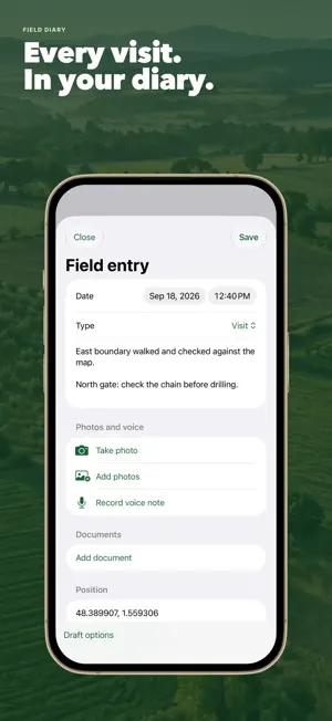
Find the official cadastral parcel you are standing on in Europe, Uruguay, Australia, New Zealand, British Columbia and three US states: North Carolina, Colorado and Connecticut. Tap the map or use your GPS position, and Boundara shows the parcel outline, its official reference and, where the source publishes it, the official area. Works in the field with no signal: download the area first and you keep the map, the parcel lines in that area, your saved parcels, your notes and your GPS position offline. New lookups need a connection. WHAT YOU CAN DO • Identify a land parcel by tapping the map or from your GPS position • Search by cadastral reference and, in many countries, in plain form too: place or district names with the parcel number, not only codes • Italy: search by comune, foglio and particella, with the cadastral lines drawn on the map • See the official area, or a calculated one labelled as such when the source has none • Measure distances, perimeters and field areas on the map • Save parcels and group them into holdings • Keep a field notebook with notes, photos, markers and voice notes transcribed on your device • Record GPS tracks, even with the screen locked • Download map areas for offline use, up to 30 areas or 100 with Pro, with more reliable downloads (not available in Switzerland) • Use Boundara on iPhone and iPad, with iCloud sync across your devices (Pro) • Apple Watch: current parcel, saved parcels, downloaded maps, GPS points, voice notes and tracks • Export PDF, KML, KMZ, GPX and GeoJSON • Spain: SIGPAC layers and a PAC summary in PDF and CSV COVERAGE Spain (whole country, including Navarre and the Basque Country), Italy (except Trento and Bolzano), France (including the overseas departments), Portugal (mainland, partial), Germany (except Bavaria), Austria, Switzerland (18 cantons), Belgium, the Netherlands, Luxembourg, Poland, Czechia, Slovakia, Slovenia, Croatia, Finland, mainland Norway, Estonia, Latvia, Lithuania, Ireland, Iceland (partial), the United Kingdom (Scotland only; England, Wales and Northern Ireland are not covered), Uruguay, Australia (New South Wales, Queensland, Victoria, Tasmania and the ACT), New Zealand, Canada (British Columbia only) and the United States (North Carolina, Colorado where 44 of 64 counties publish parcels, and Connecticut; no other states). Scotland and the US: tap the map only, no reference search. Each country uses its official cadastral service. PLANS • Free: the map, 3 cadastral lookups and 1 saved parcel • Essentials, a one-time purchase: unlimited lookups and saved parcels, notes with photos and voice recordings, markers, measurements and exports • Field, monthly, annual or one-time: everything in Essentials plus offline maps, GPS tracks, holdings, quick voice notes from the shortcut, Apple Watch with voice notes, the PAC summary and on-device AI summaries on compatible devices • Boundara Pro, monthly or annual, for professionals who work for clients: everything in Field plus clients, field-visit PDF reports with your name or company and logo, Shapefile, DXF and CSV export, read-only holding sharing, iCloud sync and up to 100 offline areas PRIVATE BY DESIGN No account, no ads and no tracking. Your data stays on your device or, if you turn on sync (Pro), in your private iCloud. Lookups go directly to the official service for the place you choose. GOOD TO KNOW Cadastral outlines and areas are informational and may be incomplete or out of date. They are not surveys, certificates, title documents or legal boundary determinations. Boundara does not show owner names. Boundara is independent and is not affiliated with or endorsed by any public authority. Your subscription renews automatically until cancelled in your Apple account settings. Support: [email protected] https://boundara.app/privacy/ https://www.apple.com/legal/internet-services/itunes/dev/stdeula/
What’s new
Version 1.5.0 · Updated October 16, 2026
New field tools for editing points, lines and areas, visit records, inspections and history. Sharper downloaded maps and smoother navigation on Apple Watch. An optional getting-started guide shows progress from your saved work.
App privacy
The developer, EUTOPIX LABS, reported these privacy practices to Apple.
Data Linked to You
The following data, which may be collected and linked to your identity, may be used for the following purposes:
- Identifiers: Device ID
Used for: App Functionality
Alternatives to European Cadastral Maps
Looking for apps like European Cadastral Maps? Here are 6 similar apps on the App Store. The highest rated is Catastro GPS: Parcel Finder (5.0/5), and all 6 are free to download.
-
 Catastro GPS: Parcel Finder
5.0
-
 Catamaps
-
 France Parcelle
-
 Geo Mapa
-
 Area Measurement by GPS Map
-
 infoCatastro
5.0
| App | Rating | Price | Last updated | Compare |
|---|---|---|---|---|
| European Cadastral Maps | – | Free | October 16, 2026 | |
| Catastro GPS: Parcel Finder | 5.0 / 5 (1) | Free | Oct 23, 2026 | Compare |
| Catamaps | – | Free | Oct 13, 2026 | Compare |
| France Parcelle | – | Free | Oct 9, 2025 | Compare |
| Geo Mapa | – | Free | Sep 10, 2026 | Compare |
| Area Measurement by GPS Map | – | Free | Aug 31, 2026 | Compare |
| infoCatastro | 5.0 / 5 (1) | Free | Aug 13, 2025 | Compare |