

天空之家
Jiangxi Future Technology Co., Ltd Utilities iPhoneiPadiPod touch
天空之家 is a free Utilities app for iPhone and iPad by Jiangxi Future Technology Co., Ltd. Requires iOS 16.4. Updated September 3, 2026.
- Price
- Free
- on the App Store
- Size
- 84 MB
- Age 4+
- Updated
- Sep 3
- 2026 · v1.2.3
Screenshots



About 天空之家
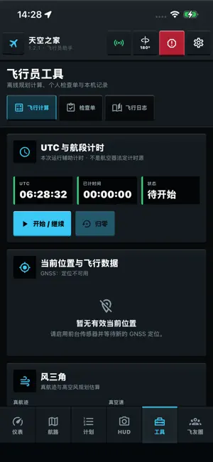
Sky Family - Pilot Assistant is an offline-first supplemental situational display for pilots, student pilots and ground training. Using the phone's motion sensors, compass and foreground GNSS, it provides an original touch PFD, a camera HUD, offline route planning, a pilot toolbox, custom checklists, a personal logbook and a one-tap emergency record. MAIN DISPLAYS • Touch PFD: roll/pitch trend, GNSS ground speed, WGS-84 GNSS altitude, true track or magnetic heading, adaptive portrait/landscape layouts. • Camera HUD: the camera runs only on the HUD page for live preview — no photos, no recording, no upload. • Data-quality gating: mocked, stale or low-accuracy fixes never enter the navigation displays. ROUTES AND MAPS • Offline MAP/FPL: route creation, waypoint ordering, active leg, distance, true bearing, ETE, OBS, and GeoJSON/GPX/KML import. • After separate map-privacy consent, AMap capability and official offline city packages are available in mainland China. Elsewhere, the app uses a configured and available map provider. Routes, waypoints, OBS and position overlays remain usable when no base map is configured or available. • Within a valid offline entitlement, route planning works without a base map, including in airplane mode. PILOT TOOLS (all computed offline on the device) • Wind triangle, runway wind components, pressure/density altitude, fuel endurance and range. • Descent planning (TOD): distance to start descent, required vertical speed, time and gradient. • Holding-entry advice using the AIM/ICAO 70° sectors (direct / parallel / teardrop). • Standard-rate turn bank and radius; still-air glide range. • Sunrise, sunset and civil twilight with one-tap use of the current GNSS fix, in UTC and device-local time. • Two-way unit converter: kt/km/h, ft/m, NM/km, °C/°F, hPa/inHg, kg/lb, L/US gal. • UTC/leg timer, custom checklists and a local personal logbook. ACCOUNTS AND SUBSCRIPTION • PFD, HUD, pilot tools and emergency records work for guests without sign-in. • MAP/FPL routes and waypoints require an account; new accounts receive one free 72-hour trial. • After the trial, users may choose an auto-renewing monthly plan, a one-month non-renewing plan, or a one-year non-renewing plan. The final price is shown by the App Store purchase sheet. • The monthly auto-renewing plan continues until canceled in App Store subscription management; cancel at least 24 hours before the current period ends. Manual plans expire without another charge. • Accounts can be deleted inside the app. • Terms of Use (EULA): https://www.apple.com/legal/internet-services/itunes/dev/stdeula/ EMERGENCY CONTROL • Saves account, UTC, position and accuracy locally first; when signed in it syncs to Sky Family operations, retrying after connectivity returns. • Important: backend receipt does not mean public search and rescue, ATC or any authority has been notified. IMPORTANT SAFETY NOTICE This app is not certified airworthy equipment and is not an approved navigation source. It does not replace required aircraft equipment, approved navigation data, current charts, NOTAMs, weather or rescue services, and must not be used for primary navigation. GS is GNSS ground speed, not airspeed; ALT is WGS-84 GNSS altitude, not barometric altitude. All calculators are planning and training aids only — fly by the aircraft manual, published procedures and ATC.
What’s new
Version 1.2.3 · Updated September 3, 2026
Adds an on-device barometric channel with QNH correction for standard pressure altitude, unpressurized installations, and cabin pressure altitude in pressurized aircraft. Devices without a pressure sensor now hide these items and explain availability in diagnostics. Emergency records now require confirmation and provide a 10-second undo window, with clearer notice that the feature does not contact ATC, police, medical, or rescue services. Improves Dynamic Island, notch, portrait safe-area layouts, and consistent three-dimensional tool buttons. Retains global metric/imperial, Celsius/Fahrenheit, and 90°/180° mounting modes.
App privacy
The developer, Jiangxi Future Technology Co., Ltd, reported these privacy practices to Apple.
Data Linked to You
The following data, which may be collected and linked to your identity, may be used for the following purposes:
- Usage Data: Product Interaction
- Other Data: Other Data Types
- Purchases: Purchase History
- Location: Precise Location
- Contact Info: Email Address, Name
- User Content: Other User Content
- Identifiers: User ID, Device ID
Used for: Analytics, App Functionality
Data Not Linked to You
The following data, which may be collected but is not linked to your identity, may be used for the following purposes:
- Diagnostics: Crash Data, Performance Data
Used for: Analytics
Alternatives to 天空之家
Looking for apps like 天空之家? Here are 6 similar apps on the App Store.


| App | Rating | Price | Last updated | Compare |
|---|---|---|---|---|
| 天空之家 | – | Free | September 3, 2026 | |
| Survivor+ | – | Free | Apr 9, 2026 | Compare |
| Pocket Cockpit | – | Free | Jul 27, 2026 | Compare |
| 航记-民航人的专属工具 | – | Free | Oct 21, 2026 | Compare |
| Smith Designer Lite | – | Free | Oct 21, 2026 | Compare |
| ToolFlow | – | Free | Oct 19, 2026 | Compare |
| HamUV | – | Free | Feb 24, 2026 | Compare |
Compare 天空之家 with the top alternatives: ratings, updates, ASO score and keyword gaps →