

Live Earth Camera - GPS Map
InfinityBridgeLimited Navigation iPhoneiPadiPod touch
Live Earth Camera - GPS Map is a free Navigation app for iPhone and iPad by InfinityBridgeLimited. Rated 3.6/5 from 57 ratings. Requires iOS 15.5.
- Rating
- 3.6
- 57 ratings
- Price
- Free
- on the App Store
- Size
- 177 MB
- Age 12+
- Updated
- Oct 18
- 2026 · v1.5.0
Screenshots



About Live Earth Camera - GPS Map
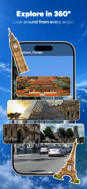
Explore the whole planet from your phone — from orbit down to the sidewalk. Spin a 3D globe, zoom into high-resolution satellite imagery of any address, then drop into street-level panoramas and look around. Along the way, check traffic, track flights overhead, read air quality, and find your bearing with a built-in compass. 3D GLOBE Start from space. Spin the globe, tilt it, and zoom smoothly down to a single street. Terrain and elevation are rendered in 3D, so mountains, coastlines and valleys keep their shape as you descend. HD SATELLITE IMAGERY High-resolution aerial and satellite imagery for locations worldwide. Zoom in on a neighborhood, follow a coastline, or look at terrain that no road map shows. Switch between satellite, terrain and standard map styles. STREET-LEVEL PANORAMAS Drop into a street and look around in 360°. Pan, tilt and move along the road to see what a place actually looks like at eye level — useful before a trip, a move, or a first visit. LIVE PUBLIC WEBCAMS Watch public webcam streams shared by their operators — beaches, city squares, mountain passes and harbors around the world. These are genuine live streams, updated continuously by the people who run them. GPS, COMPASS AND ROUTES See where you are, which way you are facing, and how to get somewhere. A built-in compass shows your heading, and route directions get you from your current location to any place you find on the map. TRAFFIC Color-coded traffic conditions on the map, so you can see where things are moving and where they are not before you leave. FLIGHT TRACKER See aircraft currently in the sky above an area, with route and altitude details for the flights you tap. AIR QUALITY Current air quality readings for locations around the world, so you know what the air is like before you head out. FAST AND LIGHT Maps load quickly and the app stays light on battery, so you can keep exploring without watching your charge drain. HOW THE IMAGERY WORKS Please read this before downloading, so you know exactly what you are getting. Satellite and aerial imagery in this app comes from mapping data providers and is captured periodically — not continuously. Depending on the location, the most recent image may be weeks, months or longer old. This is true of every consumer mapping app: no publicly available service shows a real-time satellite feed of a specific address, and this app does not either. Street-level panoramas are photographs taken at a point in time and are also not live. The one genuinely live part of the app is the public webcam section, where streams are provided in real time by the camera operators themselves. Camera availability depends on those operators and can change without notice. ABOUT THIS APP Live Earth Camera - GPS Map is an independent map and imagery viewer. It is not affiliated with, endorsed by, or sponsored by Google, Apple, or any mapping, satellite or imagery provider. Map, imagery, traffic, flight and air quality data are supplied by third-party providers, and coverage, accuracy and update frequency vary by location and by provider. This app does not provide surveillance of private property, does not show live imagery of any specific address, and cannot be used to observe people or places in real time. Subscription details, pricing and terms are shown in the app before any purchase is confirmed. Payment is charged to your Apple Account at confirmation of purchase. A subscription renews automatically unless it is turned off at least 24 hours before the end of the current period. You can manage or cancel your subscription in your Apple Account settings. Terms of Use: https://www.apple.com/legal/internet-services/itunes/dev/stdeula/
Ratings & reviews
3.6
57 ratings
What’s new
Version 1.5.0 · Updated October 18, 2026
fix some bug
App privacy
The developer, InfinityBridgeLimited, reported these privacy practices to Apple.
Data Used to Track You
The following data may be used to track you across apps and websites owned by other companies:
- Identifiers: Device ID
Data Linked to You
The following data, which may be collected and linked to your identity, may be used for the following purposes:
- Identifiers: Device ID
Used for: Developer’s Advertising or Marketing, Analytics, Product Personalization
Data Not Linked to You
The following data, which may be collected but is not linked to your identity, may be used for the following purposes:
- Usage Data: Product Interaction
- Diagnostics: Crash Data, Performance Data
- Location: Precise Location
Used for: Analytics, App Functionality
Alternatives to Live Earth Camera - GPS Map
Looking for apps like Live Earth Camera - GPS Map? Here are 6 similar apps on the App Store. The highest rated is Sky Radar: Live Flights (4.6/5), and all 6 are free to download.
-
 Live World : GPS Map
3.7
-
 Cando Translator—World Talk
3.9
-
 CamRoam: Live Map & GPS
4.0
-
 OrbiScope
2.9
-
 Sky Radar: Live Flights
4.6
-
 LiveGlobe: GPS Map Camera
3.7
| App | Rating | Price | Last updated | Compare |
|---|---|---|---|---|
| Live Earth Camera - GPS Map | 3.6 / 5 (57 ratings) | Free | October 18, 2026 | |
| Live World : GPS Map | 3.7 / 5 (167) | Free | Oct 10, 2026 | Compare |
| Cando Translator—World Talk | 3.9 / 5 (10) | Free | May 27, 2026 | Compare |
| CamRoam: Live Map & GPS | 4.0 / 5 (1,475) | Free | Oct 9, 2026 | Compare |
| OrbiScope | 2.9 / 5 (76) | Free | Oct 14, 2026 | Compare |
| Sky Radar: Live Flights | 4.6 / 5 (812) | Free | Aug 14, 2026 | Compare |
| LiveGlobe: GPS Map Camera | 3.7 / 5 (65) | Free | Sep 25, 2026 | Compare |