

ScoutCAT: POTA & SOTA Map
Aspen Ventures, LLC Navigation iPhoneiPadiPod touch
ScoutCAT: POTA & SOTA Map is a free Navigation app for iPhone and iPad by Aspen Ventures, LLC. Requires iOS 15.1. Updated August 18, 2026.
- Price
- Free
- on the App Store
- Size
- 36 MB
- Age 4+
- Updated
- Aug 18
- 2026 · v1.0
Screenshots



About ScoutCAT: POTA & SOTA Map
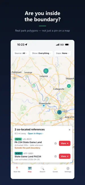
ScoutCAT is a free activation-planning map for ham radio operators. Over 380,000 "on the air" references — parks, summits, bunkers and lakes — on one fast map that works with no signal at all. FIVE PROGRAMS, ONE MAP • POTA — Parks on the Air • SOTA — Summits on the Air • WWFF — World Wide Flora & Fauna • WWBOTA — Worldwide Bunkers on the Air • LLOTA — Lagos y Lagunas on the Air Co-located references are grouped together, so you can see at a glance where a POTA park and a WWFF reference share the same ground — and work both in a single outing. FIND WHAT NOBODY HAS WORKED • Filter to references that have NEVER been activated • Or nothing in the last year • Chase band and mode firsts: no CW, no phone, no data, no 80m, no 40m, no 20m and more Gap filters use each program's own published activation data, so the depth varies by program: bunkers carry a full band-and-mode matrix, parks carry modes, and summits and flora & fauna references carry activation counts and dates. WORKS WITH ZERO SIGNAL Download the reference database once and everything runs on your phone — map, search, filters, distances and activation history. No cell service, no Wi-Fi, no account. Choose just the regions you care about, or take the whole world with you. KNOW WHERE THE BOUNDARY IS ScoutCAT draws real park boundary polygons and tells you whether the spot you are standing on is inside or outside the reference — not just a pin dropped in the middle. PLAN THE OUTING • Near Me — every reference sorted by distance and bearing • Search the whole database by name or designator • Save a want-to-go list and keep private notes on each one • Mark references you have already activated, and hide them • Open any reference in Apple Maps or Google Maps ON EVERY REFERENCE Last activated date, activation and QSO counts, elevation and SOTA points, grid square, coordinates, and a link to the program's own page. FREE, AND NO ACCOUNT No sign-up, no ads, no tracking, no analytics, no subscription. Your location is used on your device to sort what is near you and never leaves your phone. Data courtesy of Parks on the Air®, Summits on the Air, WWFF, WWBOTA and LLOTA. ScoutCAT is an independent tool and is not affiliated with or endorsed by these programs.
App privacy
The developer, Aspen Ventures, LLC, reported these privacy practices to Apple.
Data Not Collected
The developer does not collect any data from this app.
Alternatives to ScoutCAT: POTA & SOTA Map
Looking for apps like ScoutCAT: POTA & SOTA Map? Here are 6 similar apps on the App Store. The highest rated is Grid Square Life (4.4/5), and 4 of the 6 are free to download.
-
 APRS World
-
 Beech Lane RV Tank Monitoring
-
 MTN ADV Trail App
-
 Heritage Trees
4.0
-
 Grid Square Life
4.4
-
 Go Newport
| App | Rating | Price | Last updated | Compare |
|---|---|---|---|---|
| ScoutCAT: POTA & SOTA Map | – | Free | August 18, 2026 | |
| APRS World | – | Free | Aug 30, 2026 | Compare |
| Beech Lane RV Tank Monitoring | – | Free | Jun 4, 2026 | Compare |
| MTN ADV Trail App | – | 4.99 USD | Jul 14, 2026 | Compare |
| Heritage Trees | 4.0 / 5 (1) | Free | Jan 19, 2026 | Compare |
| Grid Square Life | 4.4 / 5 (5) | 3.99 USD | Jun 8, 2026 | Compare |
| Go Newport | – | Free | May 22, 2025 | Compare |