

Mil Weather
Kevin Bobb Weather iPhoneiPadiPod touch
Mil Weather is a free Weather app for iPhone and iPad by Kevin Bobb. Rated 5.0/5 from 4 ratings. Requires iOS 15.0. Updated August 19, 2026.
- Rating
- 5.0
- 4 ratings
- Price
- Free
- on the App Store
- Size
- 2 MB
- Age 4+
- Updated
- Aug 19
- 2026 · v1.2
Screenshots


About Mil Weather
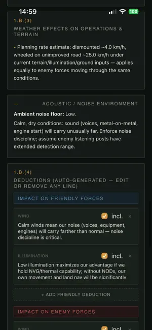
Mil Weather turns scattered weather lookups into a single planning screen. Enter a location by town, coordinates, or MGRS grid, and get the conditions that drive planning decisions — light, visibility, wind, precipitation, and terrain — in one pass. LOCATION, YOUR WAY Enter a place by town name, latitude/longitude, or MGRS grid, or pull your position from GPS. Conversion runs both directions with full UTM projection math, accurate to one meter — not a lookup table or an approximation. ILLUMINATION AND LIGHT DATA Sunrise, sunset, and the twilight phases. Moonrise, moonset, and phase, computed automatically for your location and date. Percent illumination for the night ahead. WEATHER THAT ANSWERS PLANNING QUESTIONS Temperature, dew point, and wind chill. Wind speed, gusts, and direction. Cloud cover, ceiling height, and visibility. Precipitation probability and expected amount, hour by hour. CALCULATED FIELDS Density altitude for aviation planning. Sea state for coastal and riverine work. Movement rate estimates factoring terrain and conditions. These run on your device and work with no signal. LIVE DATA, PUBLIC SOURCES Forecast and marine data from the National Weather Service and NOAA. Hydrology and river stages from USGS. Sun and moon calculations from the U.S. Naval Observatory. Every request goes over a secure connection to a public government source. WORKS WHEN THE SIGNAL DOESN'T Coordinate conversion, illumination math, density altitude, dew point, wind chill, and movement estimates all run offline on the device. Live forecast data needs a connection; the calculations don't. SAVE YOUR MISSIONS Store planning sessions on your device and pull them back up later. Nothing leaves your phone. PRIVATE BY DESIGN No account. No sign-in. No analytics, no advertising, no tracking. Saved data stays on your device and is never transmitted to us — because there is no server to transmit it to. Mil Weather is a planning aid built on public forecast data. Forecasts are estimates. Verify anything that matters against your official sources before it drives a decision.
What’s new
Version 1.2 · Updated August 19, 2026
Upon user request we have added hourly data that surpasses the previous version which only showed 24 hours out. You can now input the date of your future ops and we will generate all information you need for success. We have also added a feature for movement rate analysis that includes the option to put in the carried weight to give dismounted movement speeds.
App privacy
The developer, Kevin Bobb, reported these privacy practices to Apple.
Data Not Collected
The developer does not collect any data from this app.
Alternatives to Mil Weather
Looking for apps like Mil Weather? Here are 6 similar apps on the App Store. The highest rated is BoatUS - Boat Weather & Tides (4.8/5), and all 6 are free to download.
-
 A sun in your pocket
-
 VNL Weather
4.6
-
 Kestrel LiNK
2.9
-
 NOAA Marine Forecast: Buoycast
4.6
-
 Marine Weather Forecast Pro
4.7
-
 BoatUS - Boat Weather & Tides
4.8
| App | Rating | Price | Last updated | Compare |
|---|---|---|---|---|
| Mil Weather | 5.0 / 5 (4 ratings) | Free | August 19, 2026 | |
| A sun in your pocket | – | Free | Oct 20, 2026 | Compare |
| VNL Weather | 4.6 / 5 (8,980) | Free | Oct 21, 2026 | Compare |
| Kestrel LiNK | 2.9 / 5 (31) | Free | Sep 3, 2026 | Compare |
| NOAA Marine Forecast: Buoycast | 4.6 / 5 (13,687) | Free | Oct 6, 2026 | Compare |
| Marine Weather Forecast Pro | 4.7 / 5 (16,446) | Free | Oct 7, 2026 | Compare |
| BoatUS - Boat Weather & Tides | 4.8 / 5 (58,348) | Free | Aug 13, 2026 | Compare |
Compare Mil Weather with the top alternatives: ratings, updates, ASO score and keyword gaps →