

How's the Canyon?
Joe Pantuso Travel iPhoneiPadiPod touch
How's the Canyon? is a free Travel app for iPhone and iPad by Joe Pantuso. Rated 5.0/5 from 1 ratings. Requires iOS 18.0. Updated October 21, 2026.
- Rating
- 5.0
- 1 ratings
- Price
- Free
- on the App Store
- Size
- 6 MB
- Age 4+
- Updated
- Oct 21
- 2026 · v1.6
Screenshots



About How's the Canyon?
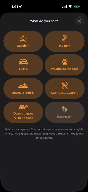
Everyone who drives between Bozeman and Big Sky asks the same question. Now there is an app that answers it. US-191 through the Gallatin Canyon has a cellular dead zone nearly as long as the drive itself. Whatever happens in there stays invisible until somebody comes out the other end. (Same with dead zones on the Madison side) Roughly 140 crashes a year. 34 white crosses in 16 years on the approach alone. 22 miles where not even a text gets out. How's the Canyon fills that hole with the only thing that works in a dead zone: the drivers already inside it. Your phone quietly times the drive, holds the record until you have signal again, and sends it. Everyone gets to see what the canyon is actually doing. WHAT YOU GET Real drive times, measured by real drivers on the real road, not estimated by an algorithm in Seattle. Montana DOT's official surface conditions for each stretch of the drive, shown next to the newest real drive time so you can compare the two yourself. Pavement temperature from Montana DOT's road sensors on MT-64 and at Norris Hill, next to the air temperature, because the two are often nothing alike and only one of them decides whether there is ice. Snow coming to the corridor, in words rather than decimal places, so you know what is arriving and roughly when. The Madison side is covered as well: MT-84, US-287 down the Madison, MT-87 over Raynolds Pass, US-20 through Island Park, and Jack Creek Road. Off until you switch them on. Weather alerts for the canyon routes specifically, not for the whole county. Driver reports pinned to recognizable landmarks like House Rock, the 35 MPH Corner, Swan Creek, the Green Bridge. Highway Patrol incidents and road work for this corridor and nothing else, written out in plain English instead of dispatch codes. While you are driving, a heads up about anything reported on the road ahead of you. Road alerts, if you want them: a notification when a road you follow is blocked, with quiet hours so it stays silent overnight. CarPlay: conditions on the dashboard, and the report buttons, one tap each. A page that says where every number on the screen comes from, how fresh it is, and what none of it promises. WHAT IT ASKS OF YOU One permission tap. After that, the app anonymously notes when you pass mile markers on the corridor and shares the timing. That is your entire contribution. Every driver who does it makes the answer more accurate for everybody else. No account. No ads. No tracking. Nothing is tied to you. The app sleeps between drives so it stays out of your battery, and it pays attention only on the roads it times. You can also just open it and look. Contributing is optional, and the app tells you the same thing either way. WHAT IT COSTS Nothing, and it stays that way. "If I can prevent even one bad car accident all the effort will be worth providing this app. The more people using the app the more accurately we can gauge conditions and the more people have the right information to make safe choices, so making it free to everyone is important. Running it is not free though, so if you appreciate what this app provides your help defraying the cost will be greatly appreciated!" There is a tip jar inside if you want to help with the server bill. Nothing in the app sits behind it. Built in Big Sky by a neighbor who drives this road.
What’s new
Version 1.6 · Updated October 21, 2026
How's the Canyon, on your car's screen. CARPLAY Connect to CarPlay and Canyon is on the dashboard, conditions has rich information about the road ahead, and reporting is right there without touching your phone. Conditions lets you know how recent the info is in case you're in the dead zone. Then alerts, locations, reports, weather, road surface conditions and signal. Tapping weather gets you the full text of a winter storm warning and more. Within a mile of a turnout on your side of the road, the top row shows it, with a green gauge that counts down as you get closer. Report has the same eight buttons as the phone. One tap sends it. If you have satellite data available the display shows it and uses it. Connecting also wakes the app, so a drive that starts in a Big Sky driveway is ready to be timed before you reach the highway.
App privacy
The developer, Joe Pantuso, reported these privacy practices to Apple.
Data Not Linked to You
The following data, which may be collected but is not linked to your identity, may be used for the following purposes:
- Identifiers: Device ID
- Diagnostics: Other Diagnostic Data
- Location: Precise Location
Used for: Analytics, App Functionality
Alternatives to How's the Canyon?
Looking for apps like How's the Canyon?? Here are 6 similar apps on the App Store. The highest rated is Bridger Bowl (5.0/5), and 5 of the 6 are free to download.




| App | Rating | Price | Last updated | Compare |
|---|---|---|---|---|
| How's the Canyon? | 5.0 / 5 (1 rating) | Free | October 21, 2026 | |
| PassWarrior | 4.8 / 5 (1,670) | 2.99 USD | Feb 24, 2025 | Compare |
| Ski YC | 4.7 / 5 (276) | Free | Aug 15, 2026 | Compare |
| Big Sky Connect | 4.0 / 5 (26) | Free | Sep 16, 2026 | Compare |
| ParkBZN | 2.2 / 5 (6) | Free | May 19, 2026 | Compare |
| Bridger Bowl | 5.0 / 5 (4) | Free | Sep 9, 2026 | Compare |
| Yellowstone SPOTR | 4.8 / 5 (16) | Free | Jul 27, 2026 | Compare |
Compare How's the Canyon? with the top alternatives: ratings, updates, ASO score and keyword gaps →