

PIC Weather Ops
Tomasz Sarna Weather iPhoneiPadiPod touch
PIC Weather Ops is a free Weather app for iPhone and iPad by Tomasz Sarna. Requires iOS 17.0. Updated September 28, 2026.
- Price
- Free
- on the App Store
- Size
- 18 MB
- Age 4+
- Updated
- Sep 28
- 2026 · v1.2.0
Screenshots
About PIC Weather Ops
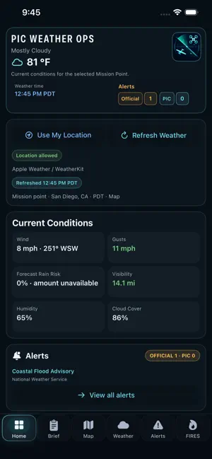
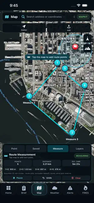
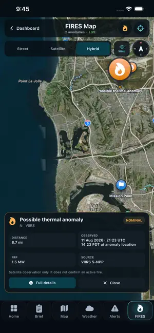
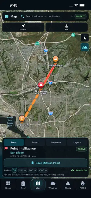
PIC Weather Ops brings weather, wind, terrain, air traffic, airspace and mission planning into one app. Built for drone pilots, RC flyers and field operators, it helps you assess conditions at your selected Mission Point, explore the surrounding area and prepare a clear mission briefing. WEATHER & WIND • Current conditions and forecasts • Wind speed, direction and gusts • Visibility, precipitation, temperature, humidity, pressure, UV and cloud cover • Weather timelines and operational weather risk indicators • Official weather alerts, including optional U.S. National Weather Service alerts SMART NOTIFICATIONS • Optional alerts for significant weather changes at your active Mission Point • Choose notification categories in Home settings AIR TRAFFIC & AIRSPACE • View reported airplanes and helicopters near your Mission Point, with available flight details and proximity advisories • Display U.S. FAA controlled airspace, special-use airspace and UAS Facility Maps as map overlays • Add FAA Temporary Flight Restrictions (TFRs), with published boundaries, NOTAM references, schedules and altitude limits • Tap airspace areas to view available details • Add an optional Zones button for quick access to airspace layers • Explore airports and heliports MISSION PLANNING & TERRAIN • Select Mission Points and save locations • Use radius tools and map-based planning • Assess terrain for planned-altitude and route awareness • Review NASA FIRMS thermal detections and fire context • Check NOAA SWPC geomagnetic Kp information • Use AR Wind View for a camera overlay with compass and weather context BRIEFINGS & REPORTS • Review your Mission Brief • Listen to the briefing with Voice Brief • Export PDF reports • Choose metric or U.S. units • View times for your selected location • Use the app in English, Spanish, French or Brazilian Portuguese DATA & OPERATIONAL RESPONSIBILITY Aircraft information depends on provider coverage and may be incomplete or delayed. FAA airspace layers cover the United States. TFR map boundaries may not cover every published restriction; check the official NOTAM for schedules, altitude limits, exceptions and notices without map geometry. NASA FIRMS observations indicate thermal anomalies, not confirmed fires. PIC Weather Ops provides planning and situational-awareness support. Map layers and advisories do not grant flight authorization. The operator/Pilot in Command remains responsible for checking official weather, NOTAMs, current airspace restrictions and applicable requirements before each operation. SUBSCRIPTION Full access requires an auto-renewable annual subscription purchased through the App Store. Your local price and any introductory offer available to your account are shown by the App Store. Privacy Policy: https://pythongite.github.io/pic-weather-site/privacy-policy.html Terms of Use (Apple Standard EULA): https://www.apple.com/legal/internet-services/itunes/dev/stdeula/
What’s new
Version 1.2.0 · Updated September 28, 2026
• Smart Notifications: optional alerts for significant weather changes at your active Mission Point. • Live Air Traffic: see reported airplanes and helicopters near your Mission Point, with available flight details and proximity advisories. • FAA Temporary Flight Restrictions (TFRs): published boundaries, NOTAM details, schedules and altitude limits. • New map layers: U.S. FAA controlled airspace, special-use airspace and UAS Facility Maps. • Airports and heliports on the Map. • Optional National Weather Service alerts for U.S. locations. • Voice Brief: listen to your Mission Brief. • Added Spanish, French and Brazilian Portuguese. • Optional Zones button for quick access to airspace layers. Aircraft data depends on provider coverage and freshness. Always verify current airspace restrictions with official sources.
App privacy
The developer, Tomasz Sarna, reported these privacy practices to Apple.
Data Linked to You
The following data, which may be collected and linked to your identity, may be used for the following purposes:
- Location: Precise Location
- Identifiers: Device ID
- Other Data: Other Data Types
Used for: App Functionality
Alternatives to PIC Weather Ops
Looking for apps like PIC Weather Ops? Here are 6 similar apps on the App Store. The highest rated is My Drone Weather (5.0/5), and all 6 are free to download.
-
 DroneWise
-
 My Drone Weather
5.0
My Drone Weather
5.0
-
 Drone Weather - Weather4Fly
4.5
Drone Weather - Weather4Fly
4.5
-
 Aviator Assistant: Pilot EFB
4.5
Aviator Assistant: Pilot EFB
4.5
-
 AURA - Smart Weather for Drone
4.5
AURA - Smart Weather for Drone
4.5
-
 Tomorrow.io Business
5.0
Tomorrow.io Business
5.0
| App | Rating | Price | Last updated |
|---|---|---|---|
| PIC Weather Ops | – | Free | September 28, 2026 |
| DroneWise | – | Free | Sep 17, 2026 |
| My Drone Weather | 5.0 / 5 (5) | Free | Jul 28, 2026 |
| Drone Weather - Weather4Fly | 4.5 / 5 (21) | Free | Sep 26, 2026 |
| Aviator Assistant: Pilot EFB | 4.5 / 5 (74) | Free | Aug 11, 2026 |
| AURA - Smart Weather for Drone | 4.5 / 5 (153) | Free | May 1, 2026 |
| Tomorrow.io Business | 5.0 / 5 (2) | Free | Aug 9, 2026 |