

Skyfield: Airport Atlas
ADVEMA Travel iPhoneiPadiPod touch
Skyfield: Airport Atlas is a free Travel app for iPhone and iPad by ADVEMA. Requires iOS 17.0. Updated September 29, 2026.
- Price
- Free
- on the App Store
- Size
- 43 MB
- Age 4+
- Updated
- Sep 29
- 2026 · v2.0
Screenshots


About Skyfield: Airport Atlas
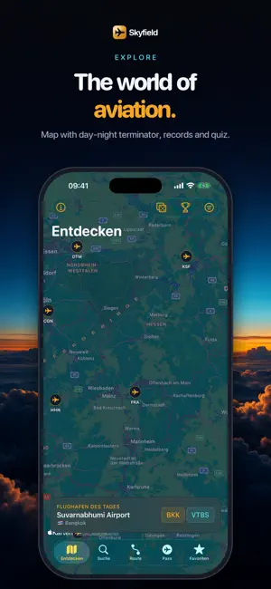
Skyfield is an offline aviation encyclopedia and a travel and route tool for everyone who loves airports: enthusiasts, flight simmers and frequent flyers. There is no live aircraft radar, on purpose. Live position data only comes with licenses that rule out a fair app. Skyfield focuses on the huge, stable world of aviation data and makes it beautiful. 85,000+ airports, fully offline Search by IATA, ICAO, name or city. Results appear instantly, even without a connection. "Munich", "MUC" and "EDDM" all find the same airport. Every airport in detail Scaled runway diagram, frequencies, navaids, local time as a glowing clock, sun position and magnetic declination. Optional live METAR weather, kept clearly separate from the offline core. Great-circle routes Two airports, one glowing arc across the dark map. Real great-circle math with distance, bearing, flight time and time-zone difference. Shareable as an image. Travel passport Check in at airports on location, collect country stamps and watch your personal world map grow. An anonymous, opt-in ranking compares you with travelers worldwide, using nickname and count only. Offline and private Core features need no network. No account, no tracking, no ads. Data Not Collected. Data: OurAirports (public domain), OpenFlights, OpenStreetMap, Natural Earth, NOAA. All data is for information only and is not suitable for aviation navigation. Skyfield Pro (subscription with a 7-day free trial, or a one-time lifetime purchase) unlocks unlimited Ask Skyfield, AI briefings, runways, frequencies, navaids, the route planner, weather forecasts, the AR sky, the world-clock board, widgets and the unlimited logbook. Search, map, sun position and the travel passport stay free. Terms of Use (EULA): https://www.apple.com/legal/internet-services/itunes/dev/stdeula/
What’s new
Version 2.0 · Updated September 29, 2026
Skyfield 2.0 – our biggest update yet: • Ask Skyfield: ask things like "How far is it from Frankfurt to Singapore?" – answered from the offline database, entirely on your device (Apple Intelligence). • AI briefing: a short description of every airport, on-device. • Weather: live METAR, now with forecast (TAF) and live wind in the runway calculator. • Travel mode: Live Activity with countdown, arrival in local time and time difference. • New travel passport widget with stats and your next flight. • Facts & figures from Wikidata, Spotlight and Siri support, Control Center buttons.
App privacy
The developer, ADVEMA, reported these privacy practices to Apple.
Data Not Collected
The developer does not collect any data from this app.
Alternatives to Skyfield: Airport Atlas
Looking for apps like Skyfield: Airport Atlas? Here are 6 similar apps on the App Store. The highest rated is Stayed: Hotel Passport (5.0/5), and all 6 are free to download.
-
 Arclune
-
 Stayed: Hotel Passport
5.0
-
 RampMeet
-
 FindMyTraveler Flight Tracker
-
 Flybound: VFR Day-Trip Planner
5.0
-
 My GPS Altitude
| App | Rating | Price | Last updated | Compare |
|---|---|---|---|---|
| Skyfield: Airport Atlas | – | Free | September 29, 2026 | |
| Arclune | – | Free | Jul 2, 2026 | Compare |
| Stayed: Hotel Passport | 5.0 / 5 (1) | Free | Oct 4, 2026 | Compare |
| RampMeet | – | Free | Aug 1, 2026 | Compare |
| FindMyTraveler Flight Tracker | – | Free | Aug 29, 2026 | Compare |
| Flybound: VFR Day-Trip Planner | 5.0 / 5 (2) | Free | Oct 18, 2026 | Compare |
| My GPS Altitude | – | Free | Aug 10, 2026 | Compare |