

Earthquake Alerts & Live Map
Alper Sumer Guc Weather iPhoneiPadiPod touchApple Watch
Earthquake Alerts & Live Map is a free Weather app for iPhone and iPad by Alper Sumer Guc. Rated 4.4/5 from 14 ratings. Requires iOS 17.6.
- Rating
- 4.4
- 14 ratings
- Price
- Free
- on the App Store
- Size
- 27 MB
- Age 4+
- Updated
- Oct 28
- 2026 · v3.2.2
Screenshots


About Earthquake Alerts & Live Map
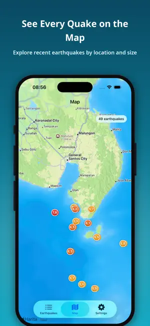
Earthquakes shows the latest earthquakes around the world the moment they are reported — with official data from the USGS, the EMSC and Türkiye's AFAD. Whether you live near a fault line, have loved ones in a quake-prone area, or simply want to stay informed, Earthquakes keeps you a step ahead with real-time data, clear maps, and timely alerts — and now a whole toolbox for understanding earthquakes. KEY FEATURES • Real-time worldwide list from the USGS, EMSC and AFAD. Your country is detected automatically on launch. • Smart alerts: get notified when an earthquake passes the magnitude you choose. • Near Me: earthquakes around your location, sorted by distance, with an adjustable radius. • Powerful filters by country, magnitude, and time. If the last 24 hours were quiet, the list widens on its own. • Full details for every event: magnitude, depth, exact time, an interactive map, ShakeMap shaking, felt reports, and PAGER impact. • Home Screen and Lock Screen widgets, and earthquake cards you can share in seconds. • Works offline — earthquakes you have loaded stay available without a connection. NEW: TOOLS • Fault Map: the active faults in your country, and how far the nearest mapped fault is from you. • Historical Earthquakes: more than 2,400 great earthquakes from 2150 BC to today, with deaths, damage, and tsunamis. • Volcanoes, Orogens, and Nuclear Power Plants maps, each opening on your country. • Magnitude Comparator: see why an M7 releases about 32 times the energy of an M6. • Rupture Size: how long a fault breaks in an earthquake, drawn to scale over your own city. • Intensity Scale and Shake Simulator: what each level of shaking feels like — and feel it through your phone. • Home Safety Check, Be Prepared, Emergency Mode (whistle and flashing light), and I'm Safe. • Statistics: charts for the earthquakes in your list. GEOLOGY ON EVERY MAP • Fault lines, plate boundaries colored by type (convergent, divergent, transform), and plate names. • Orogens, volcanoes, and nuclear power plants as layers — on the earthquake details map too. FOR EVERYONE • 26 languages with an in-app language switcher. • Light, dark, and system themes. • A clean, modern, distraction-free design. PRIVATE & FREE • Completely free to download and use. • No sign-up or account required. • Location is used only for Near Me and distances, and only if you allow it. Earthquake data: USGS, EMSC and AFAD. Faults: GEM. Volcanoes and historical earthquakes: NOAA. Please note: alerts arrive after an earthquake has been reported by the agencies — this is not an early-warning system. This app is an informational tool and not a substitute for official emergency alerts.
Ratings & reviews
4.4
14 ratings
What’s new
Version 3.2.2 · Updated October 28, 2026
• Earthquake list redesigned: cleaner rows with the magnitude, place on two lines, and time and depth at a glance. • Swipe left on any quake to share it quickly. • Interface improvements and bug fixes.
App privacy
The developer, Alper Sumer Guc, reported these privacy practices to Apple.
Data Used to Track You
The following data may be used to track you across apps and websites owned by other companies:
- Location: Coarse Location
- Identifiers: Device ID
- Usage Data: Product Interaction, Advertising Data
Data Linked to You
The following data, which may be collected and linked to your identity, may be used for the following purposes:
- Location: Coarse Location
- Identifiers: Device ID
- Usage Data: Product Interaction, Advertising Data
Used for: Third-Party Advertising, Analytics
Data Not Linked to You
The following data, which may be collected but is not linked to your identity, may be used for the following purposes:
- Diagnostics: Crash Data, Performance Data, Other Diagnostic Data
Used for: Analytics, App Functionality
Alternatives to Earthquake Alerts & Live Map
Looking for apps like Earthquake Alerts & Live Map? Here are 6 similar apps on the App Store. The highest rated is Earthquake Tracker & Alerts X (5.0/5), and all 6 are free to download.
-
 Earthquake Hub & Alerts
4.5
-
 Seismo - Earthquake Alerts
4.5
-
 QuakeReady: Earthquake Alerts
4.7
-
 Earthquake Tracker & Alerts X
5.0
-
 Earthquake: Tracker & Alerts
4.7
-
 My Earthquake - alerts and map
4.0
| App | Rating | Price | Last updated | Compare |
|---|---|---|---|---|
| Earthquake Alerts & Live Map | 4.4 / 5 (14 ratings) | Free | October 28, 2026 | |
| Earthquake Hub & Alerts | 4.5 / 5 (30) | Free | Oct 19, 2026 | Compare |
| Seismo - Earthquake Alerts | 4.5 / 5 (66) | Free | Nov 5, 2026 | Compare |
| QuakeReady: Earthquake Alerts | 4.7 / 5 (140) | Free | Nov 5, 2026 | Compare |
| Earthquake Tracker & Alerts X | 5.0 / 5 (8) | Free | Oct 22, 2026 | Compare |
| Earthquake: Tracker & Alerts | 4.7 / 5 (329) | Free | Oct 18, 2026 | Compare |
| My Earthquake - alerts and map | 4.0 / 5 (9) | Free | Sep 29, 2026 | Compare |