

Box the Wind
Jefferson Wagener Sports iPhoneiPadiPod touch
Box the Wind is a free Sports app for iPhone and iPad by Jefferson Wagener. Rated 5.0/5 from 3 ratings. Requires iOS 16.0. Updated October 12, 2026.
- Rating
- 5.0
- 3 ratings
- Price
- Free
- on the App Store
- Size
- 13 MB
- Age 12+
- Updated
- Oct 12
- 2026 · v1.4
Screenshots
About Box the Wind
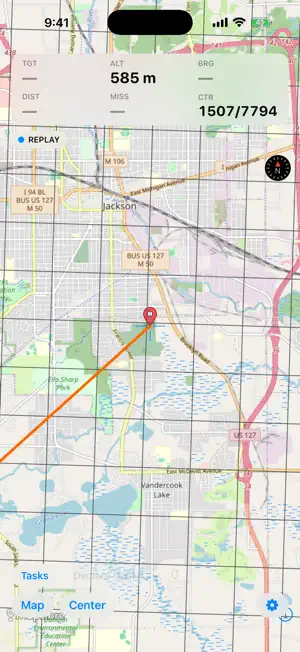
Box the Wind is for flying a balloon competition with a simplified IT layer. Fly, don't fight the computer or app. It's for the pilot in the basket and the crew chasing them. This is a competition-specific ballooning app, not a general one. Its features are focused on what the competition pilot needs, and no more. It is designed to fly next to the BLS and BLA setup and replace a cumbersome IT setup. Load the day's tasks, pick a target, and get live bearing, distance, and closest approach on your current drift. See the contest area, the prohibited zones, and the balloon live. The maps work both online and offline, in case of a lost signal aloft. WHAT'S IN IT • Tasks, shared. Import a WatchMeFly task sheet via URL (web page or PDF), edit it, tap a target to make it active. Marker color, number, and timing sit right in the list. Long-press the active target on the map to nudge it, or open map to add a task or a target there. The crew can import the pilot's tasks whenever they change, or run their own version. • The wind cone. Your measured drift by altitude plus a forecast sounding or an imported measured profile, with an AGL bar carrying the cone edges, where you are, and the altitudes whose drift heads at the target. • Live tracking support for the crew. Position flows pilot to crew over a private channel in real time. A clear stale marker shows if the link drops. The crew's own position shows too. • Declare goals easily. Auto-find the 4/4 from the display center, or key one in during flight, checked against the contest area before you commit. • Zones and warnings. Import your regions, roads, and contest boundary from KML, PLT, or GPX, keeping the colors and names the files carry. Audible and on-screen warnings fire as you approach or infringe, with per-zone ceilings and floors. • The tools menu. The wrench beside the gear holds the wind cone, task-to-task legs, a measuring tool, and practice drops. • Offline maps. Download street and aerial imagery for your region before launch; it renders fully offline in the air, terrain elevation included. • Practice mode. Log electronic marker drops and get the distance to the target, scored 2D or 3D against the separation altitude you set. A training tool, not official scoring. • Recording and replay. Every flight logs to GPX — replay with a transport bar, rename, share, or import. Send a track from another app and it lands here. Built to BFA/FAI AX conventions: the UTM 4/4 grid, the standard task types. Show units in metric, imperial, or a mixed mode that keeps altitude in feet and distance in meters. Actually, for real, free. No account. No ads. No tracking. Your location is used only to show your position, recording and sharing only when you want. Actively supported and listening to requests.
What’s new
Version 1.4 · Updated October 12, 2026
What's New in 1.4 • Add a task from the map with a long-press where you want it and tap New Task for a Pilot Declared Goal at that 4/4, added to the end of the list. You can also add another target to an existing task this way (e.g. for a Hesitation Waltz) • Zones keep their own colors and an imported Regions file sorts itself by the colors already in it. Red, yellow, and blue reach the categories that drive warnings; any other color draws in that color and drives no rule. • Import a measured wind profile via Settings → Winds Aloft → Import Wind Profile. This supports OTM CSV, OTM DAT, Ozi XML, and Paddy Cake sonde telemetry CSV, detected from the file's contents. It replaces prior winds aloft data. • Sounding models in the wind-model picker are more robust, with RAP Sounding and HRRR Sounding read the model's own native levels from the nearest NCEP reporting station, which is much denser near the ground. The station, its distance, and its bearing are shown beside the fetch if relevant. • The wind model grid runs to 18,000 ft AGL, the Class A floor. • A replay transport bar supports play/pause, a scrub slider with the flight clock, and the playback speed, right on the map while the source is Replay.
App privacy
The developer, Jefferson Wagener, reported these privacy practices to Apple.
Data Not Linked to You
The following data, which may be collected but is not linked to your identity, may be used for the following purposes:
- Location: Precise Location
Used for: App Functionality
Alternatives to Box the Wind
Looking for apps like Box the Wind? Here are 6 similar apps on the App Store. The highest rated is BOLDERBoulder 10K (4.8/5), and 5 of the 6 are free to download.
-
 Balloon Live
4.0
-
 New Mexico Goatheads
3.7
-
 Tennis Scoring Online
3.7
-
 NJSIAA Golf
3.4
-
 AnemoTracker
1.5
-
 BOLDERBoulder 10K
4.8
| App | Rating | Price | Last updated | Compare |
|---|---|---|---|---|
| Box the Wind | 5.0 / 5 (3 ratings) | Free | October 12, 2026 | |
| Balloon Live | 4.0 / 5 (1) | 4.99 USD | Aug 31, 2026 | Compare |
| New Mexico Goatheads | 3.7 / 5 (3) | Free | Aug 25, 2026 | Compare |
| Tennis Scoring Online | 3.7 / 5 (3) | Free | Jun 10, 2026 | Compare |
| NJSIAA Golf | 3.4 / 5 (13) | Free | Aug 7, 2026 | Compare |
| AnemoTracker | 1.5 / 5 (19) | Free | Oct 15, 2026 | Compare |
| BOLDERBoulder 10K | 4.8 / 5 (266) | Free | May 4, 2026 | Compare |
Compare Box the Wind with the top alternatives: ratings, updates, ASO score and keyword gaps →