

AviNavi
Vojtech Knyttl Navigation iPhoneiPadiPod touch
AviNavi is a free Navigation app for iPhone and iPad by Vojtech Knyttl. Requires iOS 26.0. Updated May 11, 2026.
- Price
- Free
- on the App Store
- Size
- 4 MB
- Age 4+
- Updated
- May 11
- 2026 · v1.0
Screenshots

About AviNavi
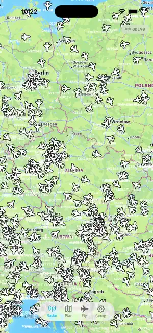
AviNavi is a VFR pilot's companion built around a single live map. Four tabs — Radar, Plan, Fly, Setup — share one view so context never resets between phases of flight. RADAR • Live ADS-B traffic with aircraft icons, callsigns, altitude and ground speed. • Tap any aircraft for a detail panel with route, photo, telemetry and recent flight history. • Airspace polygons with altitude limits, centroid and boundary labels, AUP activations under each airspace. • ATZ polygons turn red when their aerodrome has an active NOTAM — at-a-glance heads-up for current restrictions. • Airport runways drawn to scale, with METAR, frequencies and NOTAMs in the side panel. • Optional GDL90 broadcast feeds the live ADS-B picture to SkyDemon, ForeFlight and other compatible apps over Wi-Fi. PLAN • Tap to add waypoints; they snap to nearby airports, navaids or obstacles. • Long-press to drag waypoints or split a leg. • Cruise speed, altitude and fuel consumption from your active aircraft profile drive ETA and fuel-required-at-each-waypoint. • Save and load flight plans — synced across your devices via iCloud. FLY • Cockpit HUD: ALT (MSL), AGL with terrain lookup, ground speed, vertical rate, QNH from nearest METAR (within 150 NM). • Heading rose, own-ship track vector with 2/5/10-min ticks, coloured by the airspace each segment passes through. • Vertical proximity warning shades the top edge of the screen when you're approaching the floor of an airspace above. • Nearby-airspace alert engine with proximity distance to polygon edges (not just vertices). • Active flight-plan overlay with live distance and ETA to the next waypoint. • GPX track recording with start / pause / save controls; files saved to Files and iCloud Drive. • Display never dims while on this tab. WEATHER & NOTAMs • METAR, TAF and SIGMET from aviationweather.gov. • NOTAMs through Autorouter (EUROCONTROL EAD) with FIR-level fallback so warnings filed under the FIR but mentioning your aerodrome still surface. • Daily Czech AUP integration for temporary TRA/TSA activations. AIRCRAFT PROFILES • Multiple profiles with callsign, ICAO24 hex, type, cruise speed, cruise altitude and fuel consumption. • ICAO24 hex filters your own ship out of the ADS-B feed and identifies you on the GDL90 broadcast. • Profiles, saved plans and API tokens all sync via iCloud and iCloud Keychain. OFFLINE • Cached airspaces, airports, obstacles and terrain elevation continue to work without a connection. • Network errors are silenced when offline; a single banner tells you the state. AviNavi is intended as situational awareness for VFR flight. It is not a substitute for official charts, briefings or AIP publications.
App privacy
The developer, Vojtech Knyttl, reported these privacy practices to Apple.
Data Not Linked to You
The following data, which may be collected but is not linked to your identity, may be used for the following purposes:
- Usage Data: Product Interaction
- Diagnostics: Crash Data, Other Diagnostic Data
Used for: Analytics, App Functionality
Alternatives to AviNavi
Looking for apps like AviNavi? Here are 6 similar apps on the App Store. The highest rated is SkyGuard for Drones (5.0/5), and all 6 are free to download.
-
 SkyGuard for Drones
5.0
-
 ADSBWho
-
 Sky Bag
4.2
-
 Skyty: Offline Flight Tracker
-
 Airmate
4.5
-
 AirTraffic flight tracker
4.7
| App | Rating | Price | Last updated | Compare |
|---|---|---|---|---|
| AviNavi | – | Free | May 11, 2026 | |
| SkyGuard for Drones | 5.0 / 5 (1) | Free | Sep 24, 2025 | Compare |
| ADSBWho | – | Free | Oct 9, 2026 | Compare |
| Sky Bag | 4.2 / 5 (5) | Free | Jun 26, 2025 | Compare |
| Skyty: Offline Flight Tracker | – | Free | May 19, 2026 | Compare |
| Airmate | 4.5 / 5 (547) | Free | Jan 7, 2026 | Compare |
| AirTraffic flight tracker | 4.7 / 5 (691) | Free | Oct 12, 2026 | Compare |
Compare AviNavi with the top alternatives: ratings, updates, ASO score and keyword gaps →