

DepthCapture|LiDAR Point Cloud
kentaro hirahara Utilities iPhoneiPadiPod touch
DepthCapture|LiDAR Point Cloud is a free Utilities app for iPhone and iPad by kentaro hirahara. Requires iOS 17.0. Updated September 10, 2026.
- Price
- Free
- on the App Store
- Size
- 56 MB
- Age 4+
- Updated
- Sep 10
- 2026 · v1.3.9
Screenshots


About DepthCapture|LiDAR Point Cloud
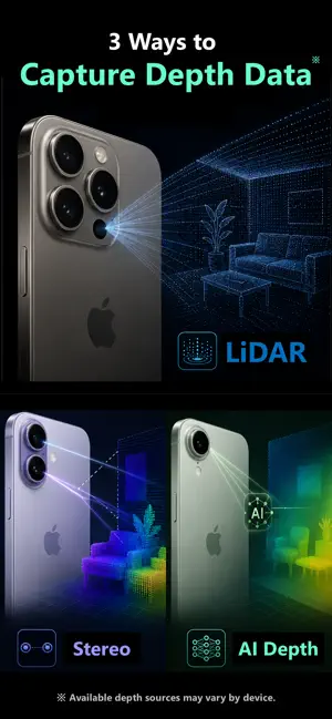
DepthCapture is an iPhone/iPad app for capturing and recording RGB images and depth data from multiple depth sources, including LiDAR, TrueDepth, supported stereo cameras, and AI-based depth estimation. View the RGB feed and depth map in real time while capturing, and visualize depth data immediately as a 3D point cloud. ―――――――――― ■ Multiple depth sources Choose from the sources supported by your device: ・LiDAR ・TrueDepth ・Stereo Depth ・AI Depth LiDAR-equipped devices can capture rear depth, while TrueDepth uses the front camera. Supported devices can also use stereo-camera depth. AI Depth estimates depth from a standard camera image using an AI model. ※ AI Depth provides relative estimates and is not calibrated to match the distance accuracy of hardware depth sources such as LiDAR or TrueDepth. ―――――――――― ■ Record RGB + Depth Use Snapshot Capture for still data or Stream Recording for continuous RGB-D capture. RGB: ・JPEG ・PNG Depth: ・BIN ・16-bit PNG ・TIFF ・EXR Snapshots store RGB, depth, and related capture information together. ―――――――――― ■ Real-time depth visualization View RGB and depth live while capturing. Color maps: ・Grayscale ・Blue-Red ・Viridis ・Inferno The displayed depth range can be automatic or fixed to a range you specify, so you can check data quality before saving. ―――――――――― ■ Live 3D point cloud Generate and display a 3D point cloud from the acquired depth data and camera information in real time. Point clouds can use RGB colors or depth-based coloring for direct spatial inspection. ―――――――――― ■ Export point clouds Export saved point clouds as: ・PLY ・GLB ・glTF ・PCD ・LAS ・CSV Export snapshots or individual Stream Recording frames for use with 3D software, point-cloud tools, Python, and other environments. ―――――――――― ■ Continuous RGB-D recording Stream Recording saves continuous RGB and depth data as either an RGB/depth file sequence or ROS2-compatible MCAP. MCAP can include RGB, Depth, CameraInfo, TF, and IMU / Device Motion for ROS2, robotics, and computer vision. ―――――――――― ■ Capture metadata Along with RGB and depth data, DepthCapture saves capture settings and camera information. When available, metadata includes: ・Camera Intrinsics ・Extrinsic Matrix ・Lens Distortion information ・RGB / Depth resolution ・Depth Source ・Depth Accuracy / Quality ・Depth Filtering ・Capture settings Snapshots and Recording Sessions also include manifest and metadata files describing the recorded data and capture conditions. ―――――――――― ■ Customize capture settings Adjust: ・Depth Filtering ・Depth FPS ・Depth Resolution ・RGB Resolution ・RGB / Depth Synchronization ・Depth Range ・Save Depth Preview Presets are also available for common capture settings. ―――――――――― ■ Review saved data Review Snapshots and Stream Recordings in Saved Data. Snapshots can show RGB, Depth, and 3D Point Cloud. Stream Recordings can be scrubbed and played back with RGB, Depth, and Point Cloud views. Sessions can be shared or accessed through the Files app. ―――――――――― ■ Example uses ・LiDAR and depth-sensor testing ・3D point-cloud capture and visualization ・RGB-D dataset collection ・Computer vision ・Machine-learning data collection ・Robotics and ROS2 ・AR and 3D-sensing data capture and validation ・Research, experiments, and prototyping ・Comparing depth acquisition methods Available sources, resolutions, and frame rates vary by device. Devices without LiDAR may still support TrueDepth, Stereo Depth, or AI Depth. DepthCapture records RGB-D data, lets you inspect it in 3D, and move it into your own workflow. Some advanced features require an in-app purchase or temporary access unlocked by watching a rewarded ad. ―――――――――― Terms of Use (Apple Standard EULA): https://www.apple.com/legal/internet-services/itunes/dev/stdeula/
What’s new
Version 1.3.9 · Updated September 10, 2026
- Revised the Depth and RGB resolution settings and improved resolution selection for LiDAR, TrueDepth, Stereo, and AI capture modes. - Made minor fixes and improvements to usability and stability.
App privacy
The developer, kentaro hirahara, reported these privacy practices to Apple.
Data Used to Track You
The following data may be used to track you across apps and websites owned by other companies:
- Location: Coarse Location
- Identifiers: Device ID
- Usage Data: Product Interaction, Advertising Data
Data Linked to You
The following data, which may be collected and linked to your identity, may be used for the following purposes:
- Location: Coarse Location
- Identifiers: Device ID
- Usage Data: Product Interaction, Advertising Data
Used for: Third-Party Advertising
Data Not Linked to You
The following data, which may be collected but is not linked to your identity, may be used for the following purposes:
- Diagnostics: Crash Data, Performance Data
- Purchases: Purchase History
Used for: Third-Party Advertising, Analytics, Other Purposes
Alternatives to DepthCapture|LiDAR Point Cloud
Looking for apps like DepthCapture|LiDAR Point Cloud? Here are 6 similar apps on the App Store. The highest rated is FrontDepth View (4.4/5), and all 6 are free to download.
-
 LiDAR Depth Map 3D Scanner
-
 Depth Estimation
-
 3D Lidar Viewer
3.7
3D Lidar Viewer
3.7
-
 Genpk 3D Scan
-
 FrontDepth View
4.4
FrontDepth View
4.4
-
 Spirit Net: LiDAR Scanner
4.0
Spirit Net: LiDAR Scanner
4.0
| App | Rating | Price | Last updated | Compare |
|---|---|---|---|---|
| DepthCapture|LiDAR Point Cloud | – | Free | September 10, 2026 | |
| LiDAR Depth Map 3D Scanner | – | Free | Sep 14, 2026 | Compare |
| Depth Estimation | – | Free | Jul 29, 2026 | Compare |
| 3D Lidar Viewer | 3.7 / 5 (3) | Free | Jun 30, 2026 | Compare |
| Genpk 3D Scan | – | Free | Mar 14, 2026 | Compare |
| FrontDepth View | 4.4 / 5 (5) | Free | Jun 28, 2026 | Compare |
| Spirit Net: LiDAR Scanner | 4.0 / 5 (4) | Free | Aug 13, 2026 | Compare |