

RailsMaps
Bartomiej Banasik Travel iPhoneiPadiPod touch
RailsMaps is a paid Travel app for iPhone and iPad by Bartomiej Banasik. Requires iOS 16.4. Updated October 11, 2026.
- Price
- 4.99 USD
- on the App Store
- Size
- 104 MB
- Age 4+
- Updated
- Oct 11
- 2026 · v1.0.7
Screenshots


About RailsMaps
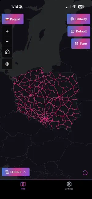
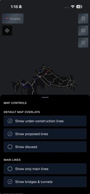
See how the rail network is built. RailsMaps maps railway, metro and tram lines in 1,150+ regions (countries, states, provinces, cities): max speeds, lines under construction, proposed routes, disused and abandoned lines, stations, level crossings, bridges and tunnels, electrification and track gauge. It's an infrastructure map, not a journey planner. Pick a region and you get every line, from national main lines to city trams, downloadable for offline use. One-time purchase. No subscription, no ads. INFRASTRUCTURE MAP MODES • Max speed: lines colored by permitted speed • Electrification: electrified lines by system and voltage (AC and DC) • Track gauge: standard, broad, narrow and mixed • Usage: main lines, branch lines, industrial, heritage and military • High-speed: dedicated high-speed lines and upgraded fast corridors • Stations and halts • Level crossings, classified by safety level • Under construction: lines and extensions being built • Proposed: planned and approved future lines • Historical: disused and abandoned railways Available map modes depend on the region and rail type. EVERY RAIL TYPE • Mainline railways, metro (subway / underground), tram, light rail, narrow gauge, monorail, funicular and miniature railways TAP FOR DETAILS • Tap any line or station for speed, gauge, electrification, usage and Wikipedia info WORKS OFFLINE • Download a region once, then use it with no connection • Offline packs are updated weekly • Detail scales with region size: city packs zoom in further than country packs, and you see the zoom range before you download • Strict offline mode: the app uses only your downloaded packs and makes no network requests • Wi-Fi-only downloads and per-region storage control MAKE IT YOURS • Built-in presets: Default and FreakMaps (infrastructure-style colors) • Custom presets: set rail line colors, widths and opacity • Save up to 20 presets, with separate colors for light and dark maps • Light, dark or auto basemap, plus an OpenStreetMap-style Carto look • Adjustable rail opacity, map labels on or off • Country and city boundary overlays • Compare two regions side by side • App theme: light, dark or system SEE WHERE YOU ARE (OPTIONAL) • Show your position on the rail network, in passive or active location mode • In active mode the map follows you along the line, handy on heritage railways and old routes BONUS: 2 WEEKS OF WEB EXPORT Buying the app includes a free 2-week map export pass for railsmaps.com and freakmaps.com. Style a map, clip it to a region and download it as a watermark-free PNG, right in your browser. One-time claim. COVERAGE • 1,150+ regions: countries, states, provinces and major cities • 13 interface languages Map data © OpenStreetMap contributors. Detail and completeness vary by region. Same data as railsmaps.com, the free web map, now on your phone.
What’s new
Version 1.0.7 · Updated October 11, 2026
• New Urban Rail map: metro, tram, light rail and monorail together on one map • Monorails can now be shown alongside tram, metro and light rail maps • Region names in your language, and region search also finds alternative names • Clearer station markers on urban rail maps • Fixed a rare crash after updating or re-downloading an offline region • Updated coverage data and stability improvements
App privacy
The developer, Bartomiej Banasik, reported these privacy practices to Apple.
Data Linked to You
The following data, which may be collected and linked to your identity, may be used for the following purposes:
- Contact Info: Email Address, Name
- Identifiers: User ID
Used for: Analytics, App Functionality
Data Not Linked to You
The following data, which may be collected but is not linked to your identity, may be used for the following purposes:
- Usage Data: Product Interaction
- Diagnostics: Crash Data, Performance Data
- Location: Precise Location, Coarse Location
- Identifiers: Device ID
Used for: Analytics, App Functionality
Alternatives to RailsMaps
Looking for apps like RailsMaps? Here are 6 similar apps on the App Store. The highest rated is TrainAtlas: Rail Trip Tracker (5.0/5), and 4 of the 6 are free to download.
-
 Disused Tube
-
 LandmarkAR
3.0
-
 Semt | Şehrini Keşfet
-
 Hawk: Dashcam & Drive Recorder
2.0
-
 Top Taxi
-
 TrainAtlas: Rail Trip Tracker
5.0
| App | Rating | Price | Last updated | Compare |
|---|---|---|---|---|
| RailsMaps | – | 4.99 USD | October 11, 2026 | |
| Disused Tube | – | 5.99 USD | Jun 27, 2025 | Compare |
| LandmarkAR | 3.0 / 5 (2) | 2.99 USD | Jun 3, 2026 | Compare |
| Semt | Şehrini Keşfet | – | Free | Jun 20, 2026 | Compare |
| Hawk: Dashcam & Drive Recorder | 2.0 / 5 (1) | Free | Oct 21, 2026 | Compare |
| Top Taxi | – | Free | Oct 1, 2025 | Compare |
| TrainAtlas: Rail Trip Tracker | 5.0 / 5 (2) | Free | Sep 28, 2026 | Compare |
Compare RailsMaps with the top alternatives: ratings, updates, ASO score and keyword gaps →