

Mountain Log Japan
Masashi Fujimoto Navigation iPhoneiPadiPod touch
Mountain Log Japan is a free Navigation app for iPhone and iPad by Masashi Fujimoto. Requires iOS 17.0. Updated October 22, 2026.
- Price
- Free
- on the App Store
- Size
- 135 MB
- Age 4+
- Updated
- Oct 22
- 2026 · v1.6.11
Screenshots


About Mountain Log Japan
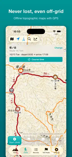
Scan your photo library and your past hikes come back as records automatically. See your progress on Japan's 100 Famous Mountains at a glance. One-time purchase - no subscription. ■ KEY FEATURES [Pick a Mountain, Pick a Course] (Updated!) - 755 standard courses for about 620 popular mountains. Course lines and elevation are built in, so the list appears instantly - Open the course list from "Search by name", or "Climb this mountain" on a mountain or hiking record. Trailheads without a standard course get an automatic round-trip course - Sort by difficulty score, course time, distance or elevation gain to find a course that fits you - Check the start time and estimated finish, then tap "Plan with this course" - the route is set and an offline map around the summit is saved in one step - "Change Descent" to finish at a different trailhead. From a hiking record, your previous course is listed too - No course fits? "Create course on map" by tapping trails, or import a GPX file [Beyond the Famous Mountains] (Updated!) - Over 480 popular and local mountains outside the famous lists, ready for search, Photo Scan and the course list - "All mountains" filter on the 100 Peaks tab: browse and search famous and other mountains together - Statistics show completion for "All mountains" and "Other mountains" [Add This Trail to Route] (New!) - Off route? Add the trail you are on to your route right there and keep getting guidance - Past a side trip, the app asks "Extend Your Route?" with a spoken prompt instead of sounding an alarm [Photo Scan] (Updated!) - Detect past climbs from the location and time of your photos - Your first import can register any number of climbs, even on the free version ■ MORE FEATURES - Trailheads, parking and bus stops: 1,500+ trailheads on the map, with directions in Apple Maps or Google Maps - Course times: time and breaks per checkpoint, planned vs. actual arrival times, nearby place names at start and end - Offline topo maps: official Geospatial Information Authority of Japan (GSI) maps, downloadable by mountain name, high detail (zoom 12-18) - GPS tracking: distance, elevation and speed in real time, in the background, with automatic backup and crash recovery - Route deviation alerts: spoken warnings and vibration, even in silent mode, with a nearby trail suggested - Sunset alerts: estimated finish time from your moving pace, with spoken warnings as sunset approaches - Lock Screen and Dynamic Island: live distance, elevation and time, plus buttons to record summit and descent - Highlight cards and timelapse videos: share photos, route map and stats; Apple Intelligence writes the post - Voice memos with transcription - Statistics: monthly and yearly charts, personal bests; multi-summit traverses in one record - 100 Peaks checklist: 12 lists, 900+ mountains, matched to your records automatically - Mountain weather: current conditions, 3-day forecast, sunrise and sunset - Trail search with color-coded trails and huts; elevation profiles - iCloud Sync (Pro), backup and restore, GPX and CSV import/export - Power Saving GPS mode, Dynamic Type, metric or imperial units ■ SUPPORTED LISTS Japan's 100, 200 and 300 Famous Mountains, plus the regional 100 Famous Mountains of Hokkaido, Tohoku, Kanto, Koshinetsu, Tokai, Kansai, Chugoku, Shikoku and Kyushu. ■ GREAT FOR - Hikers who want to compare popular standard courses before choosing - Peak baggers working through the 100 Famous Mountains - Anyone who worries about losing the trail or daylight ■ FREE AND PRO The free version saves up to 3 hiking records and 3 offline map areas (your first Photo Scan import has no limit). Pro is a one-time purchase that removes these limits and adds iCloud Sync. No subscription. ■ PRIVACY FIRST Your hiking records stay on your device and are never sent to the developer. No account required. With iCloud Sync on, they are also saved to your own iCloud. Location data is removed from saved photos.
What’s new
Version 1.6.11 · Updated October 22, 2026
[755 Standard Courses: Pick a Proven Route Instantly] - Standard courses for about 620 mountains, from the 100/200/300 Famous Mountains to popular local peaks, now appear in the course list. Trailheads and waypoints are chosen from public information such as local government sources - Course lines and elevation are built into the app, so courses show up as soon as you open the list and you can plan without waiting for trail data to download - Standard courses that walk paved or forest roads to the trailhead are now supported - Search results are split into "Mountains with courses" and "Create a course on the map" [More Popular Mountains Beyond the Famous Lists] - About 80 popular mountains added - over 480 mountains outside the famous lists, ready for search, Photo Scan and the course list - New "All mountains" filter on the 100 Peaks tab: browse and search famous and other mountains together - Statistics now show completion for "All mountains" and "Other mountains" [Add This Trail to Route - While You Hike] - Off route? Add the trail you are on to your route right there, and keep getting guidance from where you are - Walk past a side trip and the app asks "Extend Your Route?" with a spoken prompt instead of an alarm. Extend it and course times are recalculated [Unlimited First Photo Import] - Your first Photo Scan can register any number of past climbs, even on the free version. Bring in your hiking history all at once [Other] - Minor bug fixes and performance and stability improvements The free version saves up to 3 hiking records and 3 offline map areas. Try it free while picking your autumn-color hikes.
App privacy
The developer, Masashi Fujimoto, reported these privacy practices to Apple.
Data Not Collected
The developer does not collect any data from this app.
Alternatives to Mountain Log Japan
Looking for apps like Mountain Log Japan? Here are 6 similar apps on the App Store.
-
 Panorama Video Camera
-
 登山地図 やまちず
-
 RentMeJP — Luxury Car Rentals
-
 JourneyChronicle
-
 しおり作成&旅行プラン - tabi.
-
 RokuGPX: 日本の登山地図GPS
| App | Rating | Price | Last updated | Compare |
|---|---|---|---|---|
| Mountain Log Japan | – | Free | October 22, 2026 | |
| Panorama Video Camera | – | Free | Aug 14, 2026 | Compare |
| 登山地図 やまちず | – | Free | Jan 8, 2026 | Compare |
| RentMeJP — Luxury Car Rentals | – | Free | Sep 15, 2026 | Compare |
| JourneyChronicle | – | Free | Mar 29, 2026 | Compare |
| しおり作成&旅行プラン - tabi. | – | Free | Aug 3, 2026 | Compare |
| RokuGPX: 日本の登山地図GPS | – | Free | Oct 16, 2026 | Compare |
Compare Mountain Log Japan with the top alternatives: ratings, updates, ASO score and keyword gaps →