

Land Scanner
Donald Garbinski Jr Utilities iPhoneiPadiPod touch
Land Scanner is a free Utilities app for iPhone and iPad by Donald Garbinski Jr. Rated 5.0/5 from 1 ratings. Requires iOS 17.6. Updated May 5, 2026.
- Rating
- 5.0
- 1 ratings
- Price
- Free
- on the App Store
- Size
- 19 MB
- Age 4+
- Updated
- May 5
- 2026 · v1.6
Screenshots


About Land Scanner
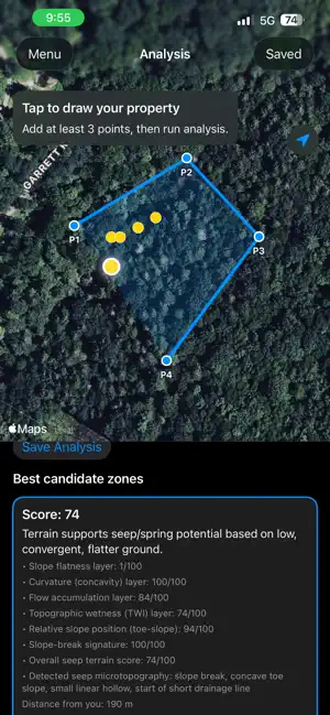
Land Scanner helps you evaluate land for spring and seep potential by analyzing terrain shape and water-convergence clues. Use Land Scanner to: • Draw your property boundary on the map • Run terrain analysis on your selected area • See ranked candidate points with clear scoring • Tap points to view why each location scored well • Save analyses for later field walking and navigation What the analysis considers: • Local slope and slope breaks • Concavity and hollow-like terrain • Flow-concentration tendencies • Relative lower-slope / toe-slope positioning Land Scanner is a terrain-screening tool, not a guarantee of groundwater emergence. On-site validation is always recommended.
What’s new
Version 1.6 · Updated May 5, 2026
Bug Fixes and Enhancements
App privacy
The developer, Donald Garbinski Jr, reported these privacy practices to Apple.
Data Not Collected
The developer does not collect any data from this app.
Alternatives to Land Scanner
Looking for apps like Land Scanner? Here are 6 similar apps on the App Store. The highest rated is News Radars (5.0/5), and 5 of the 6 are free to download.
-
 LandAI - Property Maps
4.0
-
 News Radars
5.0
-
 La Porte Support
-
 Coordinates Locator - GeoGrab
5.0
-
 Fence Mapster - Field GPS
4.0
-
 Organix Alpha
| App | Rating | Price | Last updated | Compare |
|---|---|---|---|---|
| Land Scanner | 5.0 / 5 (1 rating) | Free | May 5, 2026 | |
| LandAI - Property Maps | 4.0 / 5 (4) | Free | Oct 21, 2026 | Compare |
| News Radars | 5.0 / 5 (3) | 2.99 USD | Aug 22, 2026 | Compare |
| La Porte Support | – | Free | Aug 11, 2026 | Compare |
| Coordinates Locator - GeoGrab | 5.0 / 5 (1) | Free | Jan 9, 2026 | Compare |
| Fence Mapster - Field GPS | 4.0 / 5 (5) | Free | Oct 20, 2026 | Compare |
| Organix Alpha | – | Free | Oct 5, 2026 | Compare |
Compare Land Scanner with the top alternatives: ratings, updates, ASO score and keyword gaps →