

Place: Explore the Outdoors
MARTY RADD ICENOGGLE Reference iPhoneiPadiPod touchApple Watch
Place: Explore the Outdoors is a free Reference app for iPhone and iPad by MARTY RADD ICENOGGLE. Requires iOS 26.0. Updated October 19, 2026.
- Price
- Free
- on the App Store
- Size
- 92 MB
- Age 4+
- Updated
- Oct 19
- 2026 · v1.4
Screenshots

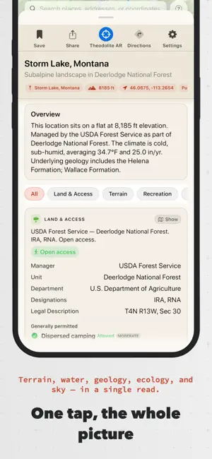


About Place: Explore the Outdoors
Place turns any location into a rich, human-readable field report — instantly. Tap the map, search by name, or use where you're standing. Place assembles terrain, geology, hydrology, land ownership, ecology, weather and hazards into a profile you can actually read in the field. UNDERSTAND ANY LOCATION 63 report sections from authoritative public data — USGS, NOAA, BLM, the Forest Service, FEMA, iNaturalist and dozens more. Terrain, bedrock geology, the watershed and stream network, land status, ecoregion, climate, and nearby species. New installs get a one-minute guided tour. GEOLOGY & DEEP TIME The bedrock beneath you in plain language, the region's rock layers oldest to youngest, and a story of how this ground came to be. Plus named landforms, glaciers, and what lived here in deep time. WATER Follow a raindrop from where you tapped, river by river, to the sea. Streamflow and snowpack from the nearest gauges, the river's gradient, tributaries and waterfalls. LAND OWNERSHIP & PARCELS Who owns and manages the ground — federal, state, tribal or private — with the managing unit, designations, what's generally permitted, agency alerts, and the legal township/range description. In 28 states Place identifies the tax parcel under your finger; in 18 of those it names the owner of record. Seven draw tappable parcel boundaries. Dispersed camping answers on BLM, National Forest, state trust and tribal land, each state's rule quoted from its agency. HUNTING & FISHING Districts, season dates, bag limits and access for all 50 states, DC and the territories — checked against each agency's own published rules and re-checked weekly, with the agency named and linked on every card. In 154 national park units the park's own rule leads, quoted from nps.gov. Hunting-district overlays by species, fishing districts, access and closure pins. HAZARDS, FREE FOR EVERYONE National Weather Service watches and warnings, avalanche danger, earthquakes, drought, burn severity, tsunami runups, smoke, and conditions from the nearest station. Answers with a safety consequence are free on every plan — and where nobody forecasts, Place says so rather than implying it's safe. MAP OVERLAYS USGS topo, satellite, BLM surface management, federal land, hunting and fishing districts, geology, biodiversity, parcels, floodplains, trails, mountain bike trails, whitewater, weather radar, contours and hillshade — 46 specialty overlays, up to five at once, each with its own opacity. Or add your own — an ArcGIS service, GeoJSON, a tile URL or a KML/GPX file — tappable and in the report. THEODOLITE AR Point your camera at a ridge and Place names the peaks with elevation, distance and bearing, live over the scene with a 3D terrain mesh. Sight a peak you know and it snaps its heading to it — the most accurate compass fix there is. GPS TRACKS Record in the background, screen off. Elevation profile, pace, waypoints, GPX/KML/GeoJSON in and out. SAVED PLACES, JOURNAL & SHARING Save a location with a note, photo and sketch, synced via iCloud. Tracks, places and observations group into trips. Share any report, place or track as a public web link — free on every plan. SIRI, WIDGETS & APPLE WATCH Ask Siri for spoken field conditions. A Live Activity keeps track stats on the Lock Screen. The Apple Watch companion puts your report, saved places and recording on your wrist. OFFLINE Download map stacks for the backcountry. Reports you've opened stay readable, tracks record with no signal, and Pro keeps working off-grid. PLACE PRO Every report section, unlimited saved places, tracks and custom layers, all 46 overlays, offline maps, Theodolite AR, PDF export, and file import and export. Even free, one Pro section unlocks each week. New installs get 7 days of full Pro — no card, nothing to cancel. For people who spend time outside and want to understand where they are, not just navigate it. Terms of Use (EULA): https://www.apple.com/legal/internet-services/itunes/dev/stdeula/
What’s new
Version 1.4 · Updated October 19, 2026
Regulations by the state, a Terrain tool that scans the whole horizon, and report cards that stay where you left them. Buy just the state you hunt. Hunting and fishing regulations are a subscription of their own now — $4.99 a year for any one of the 56 states and territories Place covers, each one separate, so you can hold Montana and Idaho at the same time for a border hunt. If you already subscribe to Place Pro, regulations stay included for you. Terrain is an instrument. Scan any bearing with a dial, set the range, read the elevation profile with a finger, and see the skyline drawn over the camera with named peaks sitting where they belong on the ridge. It reaches the Apple Watch too, for Pro. Show takes you there. Tap Show on Road Access and the layer comes on, a jeep lands on the nearest point of the road, the camera frames the whole road, and the road's card opens — Hide undoes all four. Every "Go to" now brings its own layer and card with it, a wildfire frames its perimeter, and the marker says what it landed on: TH for a trailhead, a tent for a campground, a hiker, a summit, a ski run. Report cards stay put. Cards now live for the life of the report, so scrolling back doesn't rebuild them, re-fetch them, or jump your place in the list, and the sheet re-expands where you left it. A report opened at a trailhead no longer reloads itself over and over. Your settings follow you, not the handset. Report sections, map layers, and the order you put them in now sync across your devices. The free tier has a shape. The free set of sections, any three Pro sections at a time, Terrain for three places a month, and two map overlays drawing at once. When the answer is "nothing here", it says so in one line. No protected areas, no chance of aurora, no springs in range — a short chip instead of a column of cards that could not load. And the corrections, several of which were bad. Standing at a hot spring, Thermal Springs said there were none within 100 miles. It had been reading only the first page of the catalog. In Lolo, Montana, the app told you that you were in Lolo Hot Springs, a different place up the highway. A named river now has to be within 30 meters to claim the spot, not 200. Four trail searches had been picking from an arbitrary 25 results — "92.0 mi of trail within 6.2 mi" was the giveaway. Mountain Bike Trails never decoded at all, so the card called an empty answer the answer. Tributaries never drew, because the service behind them had been retired. "Airspace unknown" turned out to be the FAA's per-minute quota rather than a fact about the sky. The Drone section knows when it is standing in a state park, and quotes the rule that applies. Hiking scores wind gusts beside sustained wind. Birding looks 100 km out instead of 25. In-season fishing emergency rules arrive dated, quoted and cited for Maine, Oregon, Pennsylvania and Washington, and disappear when they expire. Tracks export with per-point time in all three formats now, not only GPX. The tracking widget had been shipping 339 KB of images into a square the size of a thumbnail; it is 21 KB. Observed Conditions folds into Weather, where it belonged.
App privacy
The developer, MARTY RADD ICENOGGLE, reported these privacy practices to Apple.
Data Not Linked to You
The following data, which may be collected but is not linked to your identity, may be used for the following purposes:
- Location: Precise Location
- Identifiers: Device ID
Used for: App Functionality
Alternatives to Place: Explore the Outdoors
Looking for apps like Place: Explore the Outdoors? Here are 6 similar apps on the App Store. The highest rated is HOG - History On the Go audio (5.0/5), and all 6 are free to download.
-
 RockSpin
-
 New York Museum Guide
3.4
-
 FlyzBy
4.3
-
 HOG - History On the Go audio
5.0
-
 NatureLens: Species Identifier
-
 Montana Historical Markers
| App | Rating | Price | Last updated | Compare |
|---|---|---|---|---|
| Place: Explore the Outdoors | – | Free | October 19, 2026 | |
| RockSpin | – | Free | Oct 2, 2026 | Compare |
| New York Museum Guide | 3.4 / 5 (23) | Free | Aug 1, 2026 | Compare |
| FlyzBy | 4.3 / 5 (3) | Free | Oct 21, 2026 | Compare |
| HOG - History On the Go audio | 5.0 / 5 (3) | Free | Feb 27, 2026 | Compare |
| NatureLens: Species Identifier | – | Free | Apr 12, 2026 | Compare |
| Montana Historical Markers | – | Free | Mar 4, 2024 | Compare |