

Tachbase: Pilot EFB
808 Heavy Industries LLC Navigation iPhoneiPadiPod touch
Tachbase: Pilot EFB is a free Navigation app for iPhone and iPad by 808 Heavy Industries LLC. Rated 5.0/5 from 2 ratings. Requires iOS 17.0.
- Rating
- 5.0
- 2 ratings
- Price
- Free
- on the App Store
- Size
- 69 MB
- Age 4+
- Updated
- Oct 22
- 2026 · v2.6
Screenshots
About Tachbase: Pilot EFB
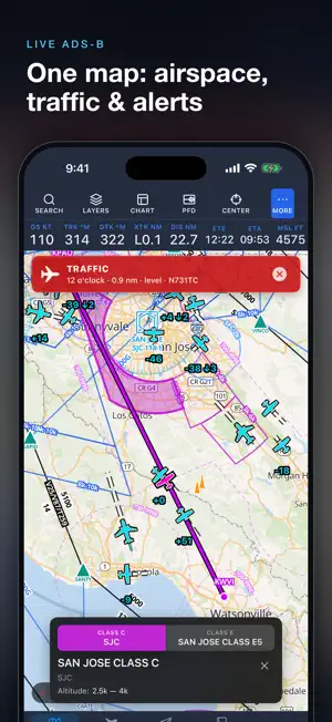
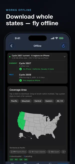
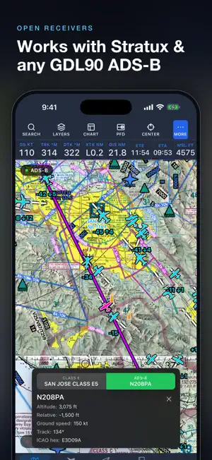
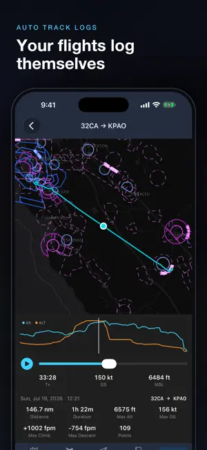
Tachbase is an electronic flight bag (EFB) for general aviation pilots — preflight planning, in-cockpit awareness, and logging in one fast, offline-first app for iPhone, iPad, and the web. NEW: TACHBASE ASSISTANT Ask in plain English — "Any NOTAMs at KSFO?", "Cat A minimums for the RNAV 31 at KPAO?", "Am I night current?" — and get answers looked up live, not from memory: weather, PIREPs and winds aloft; runways, crosswinds and Chart Supplement remarks; approach fixes and minimums from the plate; the FAR/AIM and FAA handbooks; and your own logbook, currency and aircraft. Runs on Tachbase's own servers — your questions never go to a third-party AI. Aviation only; sign in for your own records. Advisory, not an official briefing. FREE — EVERYTHING INCLUDED No subscription, nothing to buy. The moving map, charts and georeferenced plates, in-flight tools, and offline downloads all work without an account. Create a free account and nothing lives on one device: your logbook, flights, plans, aircraft, and checklists sync across iPhone, iPad, and the web — a lost iPad loses nothing. MOVING MAP Airports, airspace, navaids, fixes, airways, and MTRs — tap any feature for details. Airport diagrams draw on the map as you zoom in. Overlay VFR/IFR charts, live weather (radar, satellite, winds aloft, PIREPs, AIRMETs/SIGMETs), TFRs, and your route. Add range rings, centerlines, glide ring, and track breadcrumb. Download states & territories offline. CHARTS & PLATES FAA approach plates, departure/arrival procedures, airport diagrams, and takeoff/alternate minimums — plus taxi diagrams where the FAA has none. Plates are georeferenced (your aircraft draws on the chart); drop any chart onto the map. AIRPORTS Frequencies, runway wind analysis, METARs/TAFs, NOTAMs, fuel & services, sunrise/sunset, and the chart supplement — all offline-ready. WEATHER Decoded METARs and TAFs, 270+ imagery products cached offline, live FAA weather cameras, and FIS-B weather with an ADS-B receiver. TRAFFIC & FLIGHT INSTRUMENTS Connect any GDL90 ADS-B receiver — Stratux, Stratus 3, SkyEcho — for live traffic and weather. A PFD pairs an AHRS attitude indicator with an HSI that tracks your active leg or Direct-To. A customizable data bar adds terrain, obstacle, and traffic alerts with spoken callouts. FLIGHT PLANNING The route finder suggests routes ATC recently assigned — SIDs and STARs load with published legs on the map. Add approaches and airways; check a terrain profile with recommended MEA. Wind-corrected nav log with fuel planning, weight & balance, and PDF export. File, activate, amend, and close flight plans with Leidos Flight Services and official FAA/FSS briefings. Push alerts for plan changes and en-route weather. Direct-To with holds and track lines. CHECKLISTS Normal and emergency checklists — start from GA templates or build your own. SMART LOGBOOK Log flights with approaches, passengers, and cost-splitting; auto-log with a GPS track; track FAA currency; and generate experience and 8710 reports. Import from ForeFlight or MyFlightbook, export CSV, with 30-day undelete. Sign entries inline or via QR for instructor endorsements. AI APPS & DEVELOPERS Bring Tachbase into Claude or any MCP app, or build on our API: weather, airports, charts and regs — and, only with your approval, read-only access to your logbook, currency and aircraft. tachbase.com/developers PLUS: Home Screen widgets and a live Lock Screen flight activity; an aircraft hangar with weight & balance, POH takeoff/landing distances, and maintenance tracking; an E6B; an offline FAA library (FAR/AIM, handbooks, ACs); your own POHs and PDFs; iCloud backup; contacts; 8 themes. Tachbase supplements, not replaces, certified avionics and official sources. All data — aeronautical, weather, own-ship position — is for situational awareness only, not for primary or IFR navigation. Per FAA AC 91-78 and AC 120-76, the pilot in command must verify all information against official sources.
What’s new
Version 2.6 · Updated October 22, 2026
MEET TACHBASE ASSISTANT Ask aviation questions in plain English and get answers looked up live, not from memory: • Weather: METARs, TAFs, PIREPs, winds aloft and weather along your route • Airports: runways and crosswinds, frequencies, NOTAMs, fuel, and Chart Supplement remarks • Approaches: fixes, FAF altitudes, minimums by category and the missed approach, read from the plate • Rules and know-how: the FAR/AIM and FAA handbooks • You: your logbook, currency and aircraft, including the POH takeoff and landing distances you enter in the Hangar Chart links open right in the Plates tab. Open the Assistant from its button in the tab bar. On iPad it floats over whatever you're doing, so the map or a plate stays in view; move it, resize it, or minimize it. It runs on Tachbase's own servers; your questions never go to a third-party AI. Free, no account needed; sign in and it answers from your own records too. Advisory only, not an official briefing. ALSO IN 2.6 • Hangar: enter your POH takeoff and landing distances for each aircraft. • Hangar: every aircraft gets a category and class, filled in from its type. Seaplanes and helicopters no longer save with the wrong class. • Direct-To: Nearest lists land airports only. Heliports, seaplane bases and other facilities are labeled in search. • Logbook: the + button now uses your local date. Flights logged in the evening no longer land on tomorrow. • Light themes: warnings, NOTAM tags and status colors are easier to read on White, Cloud and Cream. • iPhone Duo: Tachbase fits both screens, folded and open. The PFD, plates and the Assistant use the whole display. • iPad with a hardware keyboard: no suggestion bar over the tab bar while you type.
App privacy
The developer, 808 Heavy Industries LLC, reported these privacy practices to Apple.
Data Linked to You
The following data, which may be collected and linked to your identity, may be used for the following purposes:
- Contact Info: Name, Phone Number, Other User Contact Info, Physical Address, Email Address
- Identifiers: User ID
Used for: Product Personalization, App Functionality, Other Purposes
Data Not Linked to You
The following data, which may be collected but is not linked to your identity, may be used for the following purposes:
- Location: Precise Location
- Identifiers: Device ID
Used for: App Functionality
Alternatives to Tachbase: Pilot EFB
Looking for apps like Tachbase: Pilot EFB? Here are 6 similar apps on the App Store. The highest rated is FlightSight (5.0/5), and 5 of the 6 are free to download.
-
 FlightSight
5.0
-
 Jeb's Flight Bag
-
 NexHawk EFB
5.0
-
 FlightSpan
5.0
-
 iBFDmonochrome
4.4
-
 A-EFIS Black and White
4.9
| App | Rating | Price | Last updated | Compare |
|---|---|---|---|---|
| Tachbase: Pilot EFB | 5.0 / 5 (2 ratings) | Free | October 22, 2026 | |
| FlightSight | 5.0 / 5 (2) | 1.99 USD | Feb 7, 2025 | Compare |
| Jeb's Flight Bag | – | Free | Jun 9, 2026 | Compare |
| NexHawk EFB | 5.0 / 5 (2) | Free | Sep 29, 2026 | Compare |
| FlightSpan | 5.0 / 5 (5) | Free | Oct 16, 2026 | Compare |
| iBFDmonochrome | 4.4 / 5 (9) | Free | Jan 15, 2025 | Compare |
| A-EFIS Black and White | 4.9 / 5 (18) | Free | Nov 18, 2024 | Compare |