

Water Snapshot
Andy Jordan Utilities iPhoneiPadiPod touch
Water Snapshot is a free Utilities app for iPhone and iPad by Andy Jordan. Rated 5.0/5 from 1 ratings. Requires iOS 16.6. Updated September 3, 2026.
- Rating
- 5.0
- 1 ratings
- Price
- Free
- on the App Store
- Size
- 35 MB
- Age 4+
- Updated
- Sep 3
- 2026 · v1.2.1
Screenshots


About Water Snapshot
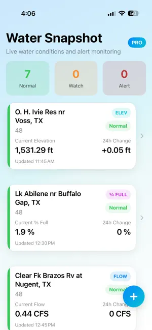
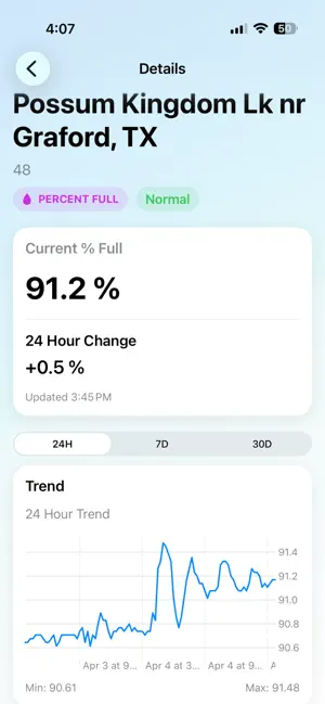
Water Snapshot gives you a clear picture of what’s happening at the rivers, lakes, reservoirs, and monitoring sites you care about using trusted USGS data and weather information from the National Weather Service. Track current water conditions, recent changes, historical trends, local weather, forecast precipitation, and active water-related NWS alerts in one clean, fast interface. Key Features • View Flow (CFS), Elevation, Gage Height, Water Temperature, and % Full • Monitor current conditions across rivers, lakes, and reservoirs • See 24-hour changes and observed ranges • Explore 24-hour, 7-day, and 30-day historical trends • View weather conditions near each monitoring site • See forecast precipitation totals for the next 24 hours, 3 days, and 7 days • See active NWS flood-related alerts directly alongside water conditions • Track multiple sites and metrics in one place • Set custom water-condition alerts and receive notifications • Quickly see which tracked sites have an active NWS flood alert Water and Weather in One Place Water conditions don't exist in isolation. Water Snapshot brings USGS measurements together with nearby weather and precipitation forecasts, helping you quickly understand what's happening around each site without jumping between multiple sources. When an active NWS flood-related alert applies near a tracked site, Water Snapshot can display the official alert alongside recent USGS measurements for additional context. Built for Real Use Whether you're working in water utilities, agriculture, recreation, or simply keeping an eye on local conditions, Water Snapshot puts useful site-specific information in one place without unnecessary clutter. Trusted Data Water measurements are sourced from the U.S. Geological Survey (USGS). Weather forecasts, precipitation outlooks, and water-related weather alerts are sourced from the National Weather Service (NWS). Percent Full values are calculated using reservoir-specific conservation capacity and elevation-based storage curves. Note Percent Full values may vary slightly from other sources depending on capacity definitions, interpolation, and data timing. Weather forecasts and alerts are provided for the area near each monitoring site and may not represent conditions across an entire watershed.
What’s new
Version 1.2.1 · Updated September 3, 2026
Improved backend connectivity and reliability.
App privacy
The developer, Andy Jordan, reported these privacy practices to Apple.
Data Linked to You
The following data, which may be collected and linked to your identity, may be used for the following purposes:
- Identifiers: User ID, Device ID
Used for: App Functionality
Data Not Linked to You
The following data, which may be collected but is not linked to your identity, may be used for the following purposes:
- Usage Data: Product Interaction
- Search History: Search History
- Diagnostics: Other Diagnostic Data
Used for: Analytics, App Functionality
Alternatives to Water Snapshot
Looking for apps like Water Snapshot? Here are 6 similar apps on the App Store. The highest rated is Battery Life Lab AI (5.0/5), and all 6 are free to download.
-
 Flow Alert
-
 Ferrell Fuel
-
 GaugeWatcher
3.8
-
 BUFF311
2.7
-
 BigBoard: Marquee LED Scroller
4.6
-
 Battery Life Lab AI
5.0
| App | Rating | Price | Last updated | Compare |
|---|---|---|---|---|
| Water Snapshot | 5.0 / 5 (1 rating) | Free | September 3, 2026 | |
| Flow Alert | – | Free | Mar 25, 2026 | Compare |
| Ferrell Fuel | – | Free | Sep 25, 2026 | Compare |
| GaugeWatcher | 3.8 / 5 (9) | Free | Sep 15, 2025 | Compare |
| BUFF311 | 2.7 / 5 (6) | Free | May 15, 2026 | Compare |
| BigBoard: Marquee LED Scroller | 4.6 / 5 (29) | Free | Mar 21, 2025 | Compare |
| Battery Life Lab AI | 5.0 / 5 (1) | Free | Mar 8, 2026 | Compare |
Compare Water Snapshot with the top alternatives: ratings, updates, ASO score and keyword gaps →