

Geopix - GPS Photo Tagger
硕 王 Photo & Video iPhoneiPadiPod touch
Geopix - GPS Photo Tagger is a free Photo & Video app for iPhone and iPad by 硕 王. Requires iOS 17.6. Updated April 8, 2026.
- Price
- Free
- on the App Store
- Size
- 18 MB
- Age 4+
- Updated
- Apr 8
- 2026 · v1.2.0
Screenshots



About Geopix - GPS Photo Tagger
Make every shot mappable and memory-rich by adding precise GPS coordinates to your DSLR & mirrorless photos — quickly, privately, and entirely offline. Key benefits: • Relive trips visually — turn shoots into cinematic 4K/1080p flyover videos and immersive 3D walkthroughs • Save time — batch-geotag hundreds of photos at once so you can focus on shooting, not organizing • Total privacy — all processing happens on-device; your photos and locations never leave your phone • Accurate matching — sub-second GPX matching and time-offset correction ensure photos land at the right coordinates • Organized workflow — Journals keep shoots, tracks and exports tidy for fast sharing and archiving How it works: Choose a map location, import GPX tracks, or record GPS directly on your iPhone. GeoPix matches photos to track points by timestamp (with a ±12h offset slider for camera clock drift) and writes professional EXIF location data while preserving original shooting parameters. Export geotagged files or create cinematic flyover videos and share them to Photos or social apps. Who it's for: Photographers using DSLR or mirrorless cameras, travelers, and mapping enthusiasts who need precise, private location data and beautiful visual storytelling of their routes. Get started now — download GeoPix to map your memories with pixel-perfect GPS and cinematic exports.
What’s new
Version 1.2.0 · Updated April 8, 2026
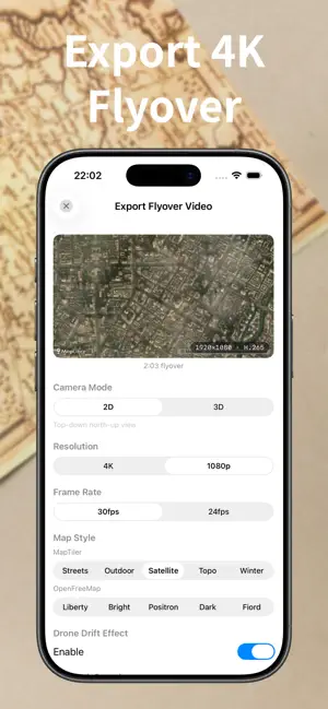
GeoPix 1.2 — Major Update with Five New Features 4K Cinematic 3D Flyover Video Export Export your photo journey as a stunning 4K/1080p flyover video. 10 map styles, 3D drone-style camera, photo pop-up animations, tactical HUD overlay (altimeter, coordinates, camera info, elevation profile). Save or share instantly. Immersive 3D Photo Walkthrough Fly over your route on a satellite map with photos appearing chronologically at their GPS coordinates. Full playback controls, speed adjustment, tap-to-view EXIF details. GPS Track Recording + Dynamic Island Record GPS tracks with your iPhone. Dynamic Island shows live stats (duration, altitude, coordinates, accuracy). Background recording with smart battery management. Use recorded tracks directly for photo matching. Multi-Track Matching Import multiple GPX tracks per journal. Smart matching automatically picks the best coordinate for each photo across all tracks. Ideal for multi-day trips. Also improved: • GPX match data now persists with journals • New photos auto-match against saved tracks • Performance and stability improvements
App privacy
The developer, 硕 王, reported these privacy practices to Apple.
Data Not Collected
The developer does not collect any data from this app.
Alternatives to Geopix - GPS Photo Tagger
Looking for apps like Geopix - GPS Photo Tagger? Here are 6 similar apps on the App Store. The highest rated is OneRoll Dual Recorder (5.0/5), and 3 of the 6 are free to download.
-
 ZOOMFLOW 1.0
-
 OneRoll Dual Recorder
5.0
-
 SoloSnap Studio
1.0
-
 OneShot Record · Studio · Ship
5.0
-
 Duo Cam: Dual Camera Video
-
 TripleShot Recorder
| App | Rating | Price | Last updated | Compare |
|---|---|---|---|---|
| Geopix - GPS Photo Tagger | – | Free | April 8, 2026 | |
| ZOOMFLOW 1.0 | – | Free | May 22, 2026 | Compare |
| OneRoll Dual Recorder | 5.0 / 5 (2) | 2.99 USD | Apr 6, 2026 | Compare |
| SoloSnap Studio | 1.0 / 5 (1) | Free | May 22, 2026 | Compare |
| OneShot Record · Studio · Ship | 5.0 / 5 (1) | 4.99 USD | Apr 29, 2026 | Compare |
| Duo Cam: Dual Camera Video | – | Free | Apr 15, 2026 | Compare |
| TripleShot Recorder | – | 6.99 USD | Apr 25, 2026 | Compare |