

topo^alpin
Timo Braun Sports iPhoneiPadiPod touch
topo^alpin is a free Sports app for iPhone and iPad by Timo Braun. Requires iOS 17.4. Updated October 9, 2026.
- Price
- Free
- on the App Store
- Size
- 10 MB
- Age 4+
- Updated
- Oct 9
- 2026 · v3.13.3
Screenshots


About topo^alpin
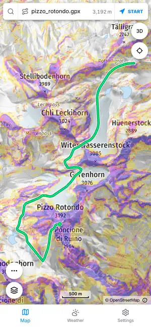
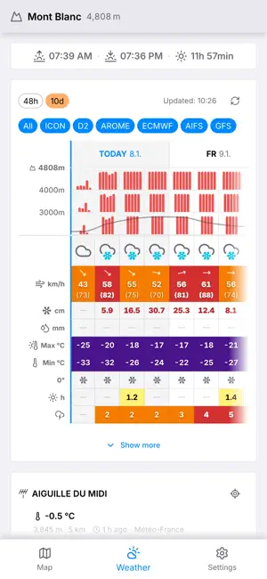
topo^alpin runs your route against the terrain it crosses, against the avalanche situation and against six weather models. The elevation profile takes on colour, and you can tap the places where it gets serious. For the whole Alpine arc. Free, ad-free, no account. THE TOUR-CHECK Upload a GPX file or draw the route on the map. The elevation profile is coloured by risk, and key sections can be tapped and assessed one by one. The avalanche terrain rating says what the terrain is like – regardless of today's conditions. Green means the day does not decide here. Red means it decides everything. Computed with the published AutoATES v2 method, as one dataset for the whole Alpine arc. MOUNTAIN WEATHER AT THE SUMMIT, NOT IN THE VALLEY A weather model's grid point can sit 2000 m below the summit, where rain falls while snow stays up top. Fresh snow, gusts, freezing level and the weather symbol therefore apply to the elevation you are standing at. Six weather models as a weighted ensemble, across 10 days and at 48-hour resolution. The elevation grid shows, band by band, whether rain or snow is falling, with the snow line drawn in. Plus thunderstorm risk, summit wind, cloud layers and elevation-corrected sun times. Measured, not forecast: snow depth and fresh snow from the nearest mountain station, out of more than 1600 stations in six countries. Official avalanche bulletins and weather warnings come with it. THE MAP Official topographic maps of Switzerland, Austria, Bavaria and France, joined seamlessly across the borders. Plus our own map for the whole Alpine arc, aerial imagery and 3D relief you can tilt and rotate. Slope angle at 5 m resolution, ski touring, snowshoe and hiking trails, wildlife and herd protection zones. Areas can be downloaded for the trip. IF SOMETHING HAPPENS The emergency location screen shows your position in decimal degrees, degrees/minutes and UTM, with elevation, fix accuracy and the nearest named terrain feature – offline too. The emergency number follows the area you are in. topo^alpin dials through the phone app and transmits no data to a control room itself. CHECK THE MATHS Method papers are published for avalanche terrain, the Tour-Check and the weather: every step from model to number, with sources and every constant we set. If you do not trust the colour on the map, you can recalculate it. topo^alpin is a decision aid, not a clearance. It shows where a closer look belongs. It replaces neither alpine experience nor the judgement you make on the spot.
What’s new
Version 3.13.3 · Updated October 9, 2026
Three new features for tour planning. Next to the slope classes there is now the "From 30°" layer: every slope from thirty degrees in a single colour — the way printed ski touring maps show it. For navigating in a whiteout, the compass now has its own large view with named directions, instead of sitting small beside the navigation figures. And the map carries a scale bar: distances are read off it instead of estimated.
App privacy
The developer, Timo Braun, reported these privacy practices to Apple.
Data Not Linked to You
The following data, which may be collected but is not linked to your identity, may be used for the following purposes:
- Location: Precise Location
Used for: App Functionality
Alternatives to topo^alpin
Looking for apps like topo^alpin? Here are 6 similar apps on the App Store. The highest rated is Peak Bagging Tracker - Cairn (1.0/5), and all 6 are free to download.
-
 Traqivo
-
 SummitList: Peak Bagging
-
 Peak Bagging Tracker - Cairn
1.0
-
 Hanglage: Hiking & Ski Tours
-
 Le Rebond Padel Cavaillon
-
 schüsss clüb, Ski Tracker
| App | Rating | Price | Last updated | Compare |
|---|---|---|---|---|
| topo^alpin | – | Free | October 9, 2026 | |
| Traqivo | – | Free | Jul 30, 2026 | Compare |
| SummitList: Peak Bagging | – | Free | Aug 2, 2026 | Compare |
| Peak Bagging Tracker - Cairn | 1.0 / 5 (1) | Free | Jun 25, 2026 | Compare |
| Hanglage: Hiking & Ski Tours | – | Free | Oct 12, 2026 | Compare |
| Le Rebond Padel Cavaillon | – | Free | May 25, 2026 | Compare |
| schüsss clüb, Ski Tracker | – | Free | Sep 16, 2026 | Compare |
Compare topo^alpin with the top alternatives: ratings, updates, ASO score and keyword gaps →