

MagentaLine
HiveByte AI, LLC Navigation iPhoneiPadiPod touch
MagentaLine is a free Navigation app for iPhone and iPad by HiveByte AI, LLC. Requires iOS 15.0. Updated October 17, 2026.
- Price
- Free
- on the App Store
- Size
- 57 MB
- Age 4+
- Updated
- Oct 17
- 2026 · v1.5.7
Screenshots


About MagentaLine
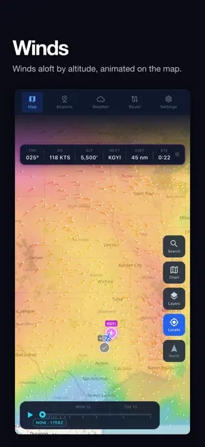
MagentaLine is an electronic flight bag for general aviation pilots. Plan a flight, brief it and fly it with charts, weather and approach plates on your iPhone or iPad, with your route drawn as a magenta line. CHARTS • VFR sectional and IFR low and high altitude charts on a moving map with your GPS position • MagentaLine's own aeronautical chart, drawn from navigation data, with map, light and dark backgrounds • Airspace, special use airspace and TFRs on the map • Download charts, approach plates and airport data to use with no connection WEATHER • METARs and TAFs, with METAR flight category colors on the map • Weather radar, satellite (GeoColor, infrared and water vapor) and lightning • Animated winds aloft by altitude, plus cloud ceiling and surface visibility forecasts • SIGMETs, AIRMETs, PIREPs, convective outlooks, prog charts and significant weather charts • FIS-B METARs, TAFs and radar with no internet, from a compatible ADS-B receiver ROUTES AND BRIEFINGS • Build routes from airports, navaids, fixes, airways and procedures • Distance, time, heading and fuel estimates from your aircraft profile and the winds aloft forecast • A route briefing with departure, destination and en route weather, airport NOTAMs and TFRs • Share a route with another MagentaLine pilot AIRPORTS AND APPROACHES • Airport details: runways and the wind-favored runway end (advisory), frequencies, and reported 100LL and Jet A prices • Approach plates and airport diagrams, with your GPS position shown on georeferenced plates • Approach briefings that list the fixes in order TRAFFIC • ADS-B traffic from GDL 90 receivers over Wi-Fi, such as Stratux, and internet traffic when you're online ALSO • Automatic flight detection, with flights ready to review and save in your logbook • Checklists, your own waypoints, and documents your flight school shares with you • Your saved routes and account preferences sync between your devices Live weather, NOTAMs and TFRs need an internet connection, or a compatible ADS-B receiver for FIS-B weather. Sign in and download your data before you fly offline. MagentaLine requires an account with an active trial, subscription or lifetime membership. MagentaLine is a supplemental situational awareness tool. Always check current official sources before flight.
What’s new
Version 1.5.7 · Updated October 17, 2026
• Zoom out to see the whole country, and further in on every chart • Stability improvements
App privacy
The developer, HiveByte AI, LLC, reported these privacy practices to Apple.
Data Linked to You
The following data, which may be collected and linked to your identity, may be used for the following purposes:
- Contact Info: Email Address
- Identifiers: User ID
Used for: App Functionality
Data Not Linked to You
The following data, which may be collected but is not linked to your identity, may be used for the following purposes:
- Location: Precise Location
- Diagnostics: Crash Data
Used for: App Functionality
Alternatives to MagentaLine
Looking for apps like MagentaLine? Here are 6 similar apps on the App Store. The highest rated is Formation Flight (5.0/5), and all 6 are free to download.


| App | Rating | Price | Last updated | Compare |
|---|---|---|---|---|
| MagentaLine | – | Free | October 17, 2026 | |
| Formation Flight | 5.0 / 5 (2) | Free | Oct 13, 2026 | Compare |
| Sky Widgets | – | Free | Sep 6, 2026 | Compare |
| Planit - Travel & Maps | 5.0 / 5 (6) | Free | Apr 12, 2026 | Compare |
| Stratus Logbook | – | Free | Oct 6, 2026 | Compare |
| AWOSLOG Pilot | – | Free | Apr 30, 2026 | Compare |
| AviateHub | – | Free | Sep 22, 2026 | Compare |
Compare MagentaLine with the top alternatives: ratings, updates, ASO score and keyword gaps →