

PeakPoint –Outdoor Toolkit
qiang zhou Travel iPhoneiPadiPod touch
PeakPoint –Outdoor Toolkit is a free Travel app for iPhone and iPad by qiang zhou. Requires iOS 16.6. Updated February 9, 2026.
- Price
- Free
- on the App Store
- Size
- 17 MB
- Age 4+
- Updated
- Feb 9
- 2026 · v1.02
Screenshots
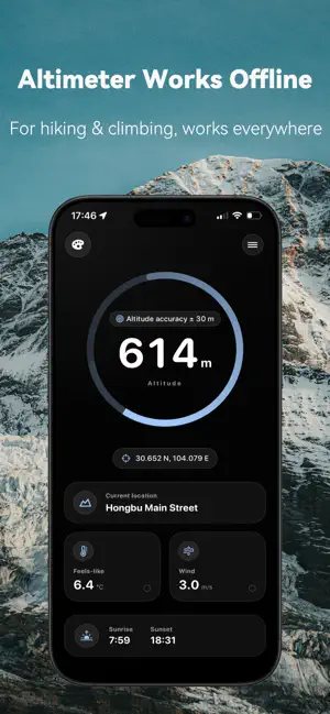


About PeakPoint –Outdoor Toolkit
PeakPoint is an altitude-focused all-in-one outdoor tool app that works continuously without internet. [All-In-One Outdoor Toolkit] Combines altitude, real-time barometric pressure, precise coordinates, compass, and level; plus key environmental data like feels-like temperature, wind speed, humidity, and UV index. Most core features work offline—perfect for extended outdoor adventures. [Hiking Status Tracking & Alerts] Displays real-time hiking speed, and alerts you to abnormal slowdowns, long stops, or rapid pressure changes. Get a clear signal to adjust your pace or take a break. [One-Tap SOS] Trigger SOS quickly in emergencies to share your location & key details—reducing stress when every second counts, and adding an extra layer of security for outdoor uncertainty. [Altitude Sickness Safety Alerts] Monitors altitude & pressure fluctuations, and calculates equivalent oxygen levels. Intuitively assess your risk of altitude sickness, no matter where you are. [Weather & Environment Warnings] Alerts you to extreme wind, UV, or humidity shifts. Translates weather data into clothing recommendations to handle sudden conditions with ease. [Check-In Optimized Mode] Double-tap the dashboard for a minimal view—only altitude & coordinates, with high-contrast design that's easy to read in bright sunlight. Capture your peak moments perfectly. [Customizable Themes] Switch between stylish themes (e.g., Golden Mountain Sunrise, Extreme Off-Road, Twilight Pink, Cyberpunk) to match your style. [Free Version Features] - Ad-free - 2 default themes - Rich home dashboard (altitude, coordinates, location, pressure, oxygen, sunrise/sunset times)—double-tap for a large, clean view - Outdoor tools: feels-like temp, UV index, wind speed, SOS, hiking speed, compass, etc. [Pro Version Unlocks] - All customizable themes - Customize 2 home dashboard slots: replace default pressure/oxygen with feels-like temp, UV index, or hiking speed - Personalized feels-like temperature: calculate based on your preferences, track your comfort, and analyze trends - Custom UV protection tips based on your skin type - Altitude profile: assess sickness risk using your profile, oxygen levels, altitude, and elevation gain - Weather trend forecasts via pressure changes—get alerts for abnormal shifts - Pro SOS: add emergency contacts, auto-fill location in SMS, and pin the SOS button to your home screen - Activity-based pace suggestions: get alerts for abnormal speed based on your chosen activity (hiking, trekking, etc.) [Need Help? Contact Us] Email: [email protected] [Privacy Policy] https://www.notion.so/2e618b06460780958461c589a7542c62?source=copy_link [End User License Agreement (EULA)] https://www.notion.so/2e618b0646078024914cfdbfac6ff924?source=copy_link (This agreement applies to all auto-renewing subscription services for this app.)
What’s new
Version 1.02 · Updated February 9, 2026
1. New Cloud & Glow Prediction tool: Enter a destination to automatically analyze the probability of sea of clouds, sunrise glow, and sunset glow, as well as the best viewing times over the next 7 days—easy for outdoor beginners to understand. 2. Added User Community Group access: Go to "Settings - User Community Group" to join and share your feedback or issues with the developers anytime.
App privacy
The developer, qiang zhou, reported these privacy practices to Apple.
Data Not Linked to You
The following data, which may be collected but is not linked to your identity, may be used for the following purposes:
- Purchases: Purchase History
- Location: Precise Location, Coarse Location
Used for: Analytics, App Functionality
Alternatives to PeakPoint –Outdoor Toolkit
Looking for apps like PeakPoint –Outdoor Toolkit? Here are 6 similar apps on the App Store. The highest rated is TopoKit: Offline Field GIS (5.0/5), and all 6 are free to download.
-
 户外工具箱-GPS经纬度,指南针定位
3.0
-
 经纬度海拔 - gps海拔表
-
 Hikely - Hike, Bike, Run
3.7
-
 TopoKit: Offline Field GIS
5.0
-
 实时海拔高度计
-
 GoLog · Life Footprint Map
4.3
| App | Rating | Price | Last updated | Compare |
|---|---|---|---|---|
| PeakPoint –Outdoor Toolkit | – | Free | February 9, 2026 | |
| 户外工具箱-GPS经纬度,指南针定位 | 3.0 / 5 (2) | Free | Aug 7, 2025 | Compare |
| 经纬度海拔 - gps海拔表 | – | Free | Mar 1, 2026 | Compare |
| Hikely - Hike, Bike, Run | 3.7 / 5 (3) | Free | Oct 23, 2026 | Compare |
| TopoKit: Offline Field GIS | 5.0 / 5 (2) | Free | Oct 25, 2026 | Compare |
| 实时海拔高度计 | – | Free | Feb 12, 2026 | Compare |
| GoLog · Life Footprint Map | 4.3 / 5 (7) | Free | Oct 16, 2026 | Compare |