

Cairn Maps
YMMV Utilities iPhoneiPadiPod touch
Cairn Maps is a free Utilities app for iPhone and iPad by YMMV. Requires iOS 18.2. Updated October 7, 2026.
- Price
- Free
- on the App Store
- Size
- 15 MB
- Age 4+
- Updated
- Oct 7
- 2026 · v1.3
Screenshots

About Cairn Maps
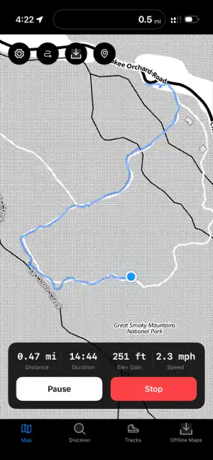
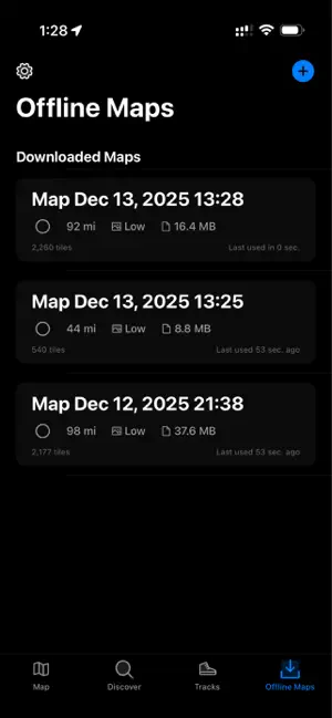
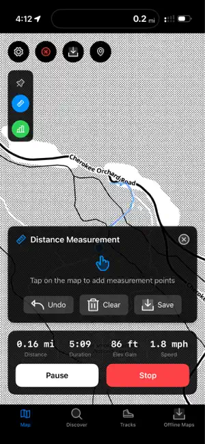
Offline Trail Maps and GPS Hiking Tracker Navigate the wilderness with confidence using Cairn, the hiking and outdoor navigation app designed for adventurers who venture beyond cell service. Whether planning a day hike or multi day backpacking trip, Cairn provides essential tools to stay on track and record your journeys. OFFLINE MAPS FOR BACKCOUNTRY EXPLORATION Download high quality topographic maps before leaving home and access them anywhere without internet connection. Save custom map regions at multiple resolution levels, ensuring detailed terrain information when you need it most. The tile-based download system optimizes storage while maintaining excellent map clarity for wilderness navigation. GPS TRACK RECORDING AND STATISTICS Record every step of your outdoor adventures with precision GPS tracking. Cairn captures your route, elevation changes, speed, and distance in real-time. Review detailed statistics including total distance, elevation gain and loss, average pace, and duration. The elevation profile visualizes your climb throughout each journey. WAYPOINT AND ROUTE PLANNING Plan adventures by creating custom routes with multiple waypoints. Drop markers at trailheads, campsites, water sources, and scenic viewpoints. The route planning system calculates total distance, cumulative elevation changes, and estimated hiking time to help you prepare for each expedition. TRAIL DISCOVERY AND SEARCH Find new trails using built-in discovery features. Search hiking paths by name, location, difficulty level, surface type, and distance. Filter results to match your preferences, from easy nature walks to challenging mountain ascents. Trail listings include length, elevation gain, estimated time, and terrain conditions. TRACK IMPORT AND EXPORT Transfer hiking data between apps and devices seamlessly. Import GPX, KML, FIT, TCX, and GeoJSON files from Garmin, AllTrails, and OnX Backcountry. Export recorded tracks to share with friends or backup your adventures. The import system preserves all track details including timestamps and elevation data. PUBLIC LAND BOUNDARIES Know where you can legally hike and camp with integrated public land boundary information. View national forests, wilderness areas, and state parks directly on the map. Plan trips within permitted areas and discover new public lands near your location. REAL TIME NAVIGATION ASSISTANCE Follow planned routes with navigation designed for trail use. The system tracks progress along routes, displays distance to upcoming waypoints, and alerts you when approaching key locations. Visual indicators show bearing and direction to keep you oriented. TRACK HISTORY Access complete hiking history organized by date with detailed statistics. Search past tracks, review performance trends, and revisit favorite trails. Track management groups activities by week, month, and year for easy progress tracking. CUSTOMIZABLE MAP DISPLAY Tailor map display with multiple overlay options. Toggle visibility of trails, waypoints, and public land boundaries. The dark-themed interface reduces eye strain while maintaining readability in bright sunlight. STORAGE MANAGEMENT Monitor offline map storage with built in tools. View space occupied by each downloaded region, delete unneeded maps, and resume interrupted downloads. KEY FEATURES Downloadable offline topographic maps GPS track recording with elevation and speed metrics Custom waypoint creation with icons Route planning with distance calculations Trail search with filtering options Import from GPX, KML, FIT, TCX, GeoJSON Public land boundary visualization Real-time navigation guidance Track history and statistics Dark theme for outdoor use Download Cairn and transform how you explore the outdoors. From local trails to remote wilderness, hike with confidence and preserve memories of every journey. Perfect for hiking, backpacking, trail running, and outdoor activities where reliable navigation matters.
What’s new
Version 1.3 · Updated October 7, 2026
- Hiking trail UI refinements - map fixes - bug fixes
App privacy
The developer, YMMV, reported these privacy practices to Apple.
Data Not Collected
The developer does not collect any data from this app.
Alternatives to Cairn Maps
Looking for apps like Cairn Maps? Here are 6 similar apps on the App Store. The highest rated is NotiSync (5.0/5), and 5 of the 6 are free to download.
-
 NotiSync
5.0
-
 Time Zone Converter — Sleeko
5.0
-
 Pocket PDF : PDF Utility
5.0
-
 One Touch Paste Keyboard
5.0
-
 Logic Circuit Simulator
3.4
-
 Swipe Delete Photos by Flicky
5.0
| App | Rating | Price | Last updated | Compare |
|---|---|---|---|---|
| Cairn Maps | – | Free | October 7, 2026 | |
| NotiSync | 5.0 / 5 (1) | Free | Aug 6, 2026 | Compare |
| Time Zone Converter — Sleeko | 5.0 / 5 (2) | Free | Aug 16, 2026 | Compare |
| Pocket PDF : PDF Utility | 5.0 / 5 (1) | Free | Apr 14, 2024 | Compare |
| One Touch Paste Keyboard | 5.0 / 5 (3) | Free | Oct 10, 2026 | Compare |
| Logic Circuit Simulator | 3.4 / 5 (46) | 2.99 USD | Feb 26, 2025 | Compare |
| Swipe Delete Photos by Flicky | 5.0 / 5 (3) | Free | May 19, 2026 | Compare |
Compare Cairn Maps with the top alternatives: ratings, updates, ASO score and keyword gaps →