

Hawaii Ocean Map
Jorma Rodieck Navigation iPhoneiPadiPod touch
Hawaii Ocean Map is a paid Navigation app for iPhone and iPad by Jorma Rodieck. Rated 5.0/5 from 5 ratings. Requires iOS 17.6. Updated September 2, 2026.
- Rating
- 5.0
- 5 ratings
- Price
- 9.99 USD
- on the App Store
- Size
- 19 MB
- Age 4+
- Updated
- Sep 2
- 2026 · v1.8.1
Screenshots


About Hawaii Ocean Map
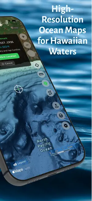
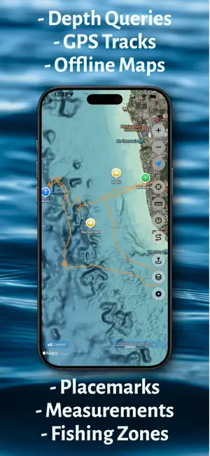
Hawaii Ocean Map brings professional-grade seafloor mapping to your iPhone and iPad. Explore the depths around the Hawaiian Islands with NOAA's high-resolution bathymetry data—all available offline, with no subscription required. PROFESSIONAL DEPTH DATA Access detailed ocean floor topography derived from NOAA's Continuously Updated Digital Elevation Model (CUDEM) at approximately 3-meter resolution. Find underwater features including reefs, ledges, channels, and drop-offs with precision. DEPTH CONTOUR LINES Toggle fathom lines at 40, 100, 200, 500, 750, 1,000, 1,500, and 2,000 fathoms, drawn and labeled on top of the color bathymetry. WORKS OFFLINE Download maps before you head out. Whether you're miles offshore or in areas with no cell coverage, your depth data is always available. Perfect for ocean adventures beyond the reach of cellular networks. INSTANT DEPTH QUERIES Tap anywhere on the map to instantly see the water depth at that location. Plan routes, identify fishing spots, or explore underwater terrain with a simple touch. SAVE LOCATIONS Mark and save your favorite spots with custom placemarks. Add names, notes, and organize your locations for quick reference on future trips. NAVIGATE TO WAYPOINTS Select any saved or imported placemark and get live bearing, distance, and a compass guiding you to your destination. Keep your eyes on the water while the app points the way. RECORD GPS TRACKS Capture your routes as you explore Hawaii's waters. Start, pause, and resume recording, then export your tracks as standard GPX files to share or analyze. Your tracks sync automatically across all your devices via iCloud. MAP LAYERS Toggle and explore ocean overlays from one dedicated page—depth contour lines, fishing restriction zones, ORMA ocean recreation areas, humpback whale sanctuary boundaries, submarine cables, and curated points of interest including harbors, boat ramps, FAD buoys, surf spots, dive spots, and lifeguard towers. Zoom directly to any layer on the map. IMPORT YOUR SPOTS Bring years of accumulated spots with you. Import KML, KMZ, and GPX files—exports from Google Earth, Navionics, Garmin, and most chartplotters and fishing apps—and each file becomes its own map layer of points, lines, and areas. Rename, show, or hide every layer, tap any feature for details, save any imported waypoint as a placemark of your own, and your imported layers sync across all your devices via iCloud. MEASURE DISTANCE & BEARING Use the built-in measurement tool to calculate distances between points on the map, with the heading and return bearing for your current leg — shown as true or magnetic to match your compass. Drag any point to fine-tune it, delete a single point, or undo the last one. Save any point — or every point at once — as placemarks, each with its depth filled in automatically. FULL ISLAND COVERAGE Complete bathymetry coverage for all major Hawaiian Islands—Oahu, Maui, Big Island, Kauai, Molokai, Lanai, and surrounding waters. NO SUBSCRIPTIONS One purchase, lifetime access. No recurring fees, no in-app purchases, no ads. Ideal for boaters, fishermen, divers, snorkelers, kayakers, and anyone who wants to understand what lies beneath Hawaii's beautiful waters. IMPORTANT: For informational and recreational purposes only. Not a marine navigation device. Always use official nautical charts and proper navigation equipment when on the water. Full terms at hawaiiocean.app/terms.
Ratings & reviews
5.0
5 ratings
What’s new
Version 1.8.1 · Updated September 2, 2026
SAVE IMPORTED WAYPOINTS AS PLACEMARKS Tap any waypoint from an imported KML, KMZ, or GPX layer and save it as a placemark of your own - depth filled in automatically, ready to favorite, rename, or navigate to. UPDATED FAD STATUSES Refreshed from the Hawaii Institute of Marine Biology (September 2026). Six FADs are back in service - Oahu S (Pokai Bay) and HH (Ewa), and Kauai Z, CK, EK, and WK - while Big Island A (Ka Lae) is newly missing.
App privacy
The developer, Jorma Rodieck, reported these privacy practices to Apple.
Data Not Linked to You
The following data, which may be collected but is not linked to your identity, may be used for the following purposes:
- Location: Precise Location
Used for: App Functionality
Alternatives to Hawaii Ocean Map
Looking for apps like Hawaii Ocean Map? Here are 6 similar apps on the App Store. The highest rated is TZ iBoat – Marine Navigation (4.6/5), and all 6 are free to download.
-
 ParkMaui
2.9
-
 ACR Product App
1.7
-
 TZ iBoat – Marine Navigation
4.6
-
 Atmos Rewards
1.4
-
 i-Boating: Marine Charts & Gps
4.5
-
 ActiveCaptain®
4.0
| App | Rating | Price | Last updated | Compare |
|---|---|---|---|---|
| Hawaii Ocean Map | 5.0 / 5 (5 ratings) | 9.99 USD | September 2, 2026 | |
| ParkMaui | 2.9 / 5 (26) | Free | Oct 19, 2026 | Compare |
| ACR Product App | 1.7 / 5 (36) | Free | May 6, 2026 | Compare |
| TZ iBoat – Marine Navigation | 4.6 / 5 (886) | Free | Oct 22, 2026 | Compare |
| Atmos Rewards | 1.4 / 5 (211) | Free | May 22, 2026 | Compare |
| i-Boating: Marine Charts & Gps | 4.5 / 5 (14,958) | Free | Sep 28, 2026 | Compare |
| ActiveCaptain® | 4.0 / 5 (5,226) | Free | Oct 27, 2026 | Compare |
Compare Hawaii Ocean Map with the top alternatives: ratings, updates, ASO score and keyword gaps →