

ShelterMap
Vincent Schiller Travel iPhoneiPadiPod touch
ShelterMap is a free Travel app for iPhone and iPad by Vincent Schiller. Requires iOS 26.0. Updated August 30, 2026.
- Price
- Free
- on the App Store
- Size
- 53 MB
- Age 4+
- Updated
- Aug 30
- 2026 · v1.9.7
Screenshots


About ShelterMap
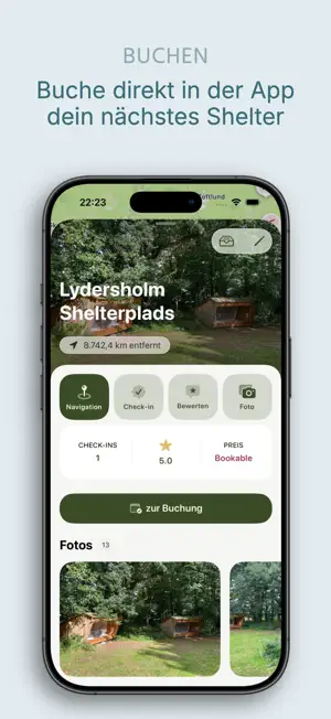
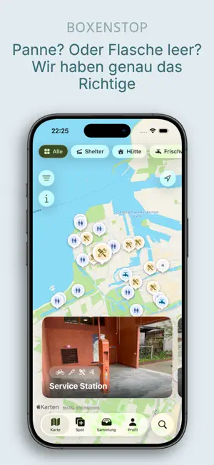
Where will I sleep tonight? Where can I find water? And does this shelter really live up to what the map promises? If you travel by bike or on foot, you know these questions. ShelterMap helps. On the map you'll find shelters and huts, but also water points, campsites and many other places that make a difference along the way. Sometimes it's a rest area with a table, sometimes a farm shop or an apple tree by the roadside. What makes ShelterMap special are the people behind it. Many spots were added by people who were actually there, others come from open data sources and are gradually completed by the community. The photos come from someone who pitched their tent in exactly that place. So do the ratings. That way you get an honest picture before you take the detour. You can see what facilities there are, whether the place costs anything and how good the mobile reception is. With Apple Look Around you can even have a look around beforehand. Once you've arrived, you check in. That way you keep track of everywhere you've been and collect small achievements along the way. Spots you want to remember go into your own collections. Handy for planning a tour, but also for your favourite places nearby. And if you know a place that's still missing, just add it. It only takes a moment, and you take the photos directly with the camera. We take a quick look at every new spot before it appears on the map, so everyone can rely on it. ShelterMap is available in German, English, Danish, Norwegian and Swedish. Good to have you here. Safe travels!
What’s new
Version 1.9.7 · Updated August 30, 2026
What’s new in 1.9.7 There’s a new spot type. Under Food & Drinks, you can now find vending machines, farm shops, small local shops and fruit trees along the road, so you can restock your supplies while you’re on the go. You can now view photos properly. Swipe between a spot’s photos, pinch with two fingers to zoom in, and simply drag the image down to close it. This works in the spot view, for the cover photo and in your own photo overview. Adding photos no longer blocks the app. Images are processed in the background, so you can continue filling in the details and even select more photos while they’re being processed. With Apple Look Around, you can preview many places before you arrive, and you can now conveniently enter opening hours when creating or editing a spot. We’ve also standardized the illustrations throughout the app, completed the Danish, Norwegian, Swedish and English translations, and made some UI improvements.
App privacy
The developer, Vincent Schiller, reported these privacy practices to Apple.
Data Linked to You
The following data, which may be collected and linked to your identity, may be used for the following purposes:
- Contact Info: Email Address
Used for: App Functionality
Data Not Linked to You
The following data, which may be collected but is not linked to your identity, may be used for the following purposes:
- Location: Precise Location, Coarse Location
- User Content: Photos or Videos
Used for: App Functionality
Alternatives to ShelterMap
Looking for apps like ShelterMap? Here are 6 similar apps on the App Store. The highest rated is Shelter (5.0/5), and all 6 are free to download.
-
 BikeTouri - Bikepacking App
-
 Vildnis
4.0
-
 TrekSpots | Tent camping map
-
 Shelter Map (Vindskyddskartan)
4.8
-
 Shelter
5.0
-
 Shelto
| App | Rating | Price | Last updated | Compare |
|---|---|---|---|---|
| ShelterMap | – | Free | August 30, 2026 | |
| BikeTouri - Bikepacking App | – | Free | Oct 10, 2026 | Compare |
| Vildnis | 4.0 / 5 (1) | Free | Jul 11, 2026 | Compare |
| TrekSpots | Tent camping map | – | Free | Aug 15, 2026 | Compare |
| Shelter Map (Vindskyddskartan) | 4.8 / 5 (5) | Free | Sep 14, 2026 | Compare |
| Shelter | 5.0 / 5 (1) | Free | Feb 18, 2025 | Compare |
| Shelto | – | Free | Sep 28, 2026 | Compare |
Compare ShelterMap with the top alternatives: ratings, updates, ASO score and keyword gaps →