

GPS Map Camera – Geotag Stamp
Brijesh Bodariya Photo & Video iPhoneiPadiPod touch
GPS Map Camera – Geotag Stamp is a free Photo & Video app for iPhone and iPad by Brijesh Bodariya. Requires iOS 15.0. Updated February 3, 2026.
- Price
- Free
- on the App Store
- Size
- 133 MB
- Age 4+
- Updated
- Feb 3
- 2026 · v1.0.4
Screenshots


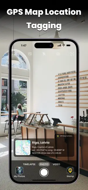

About GPS Map Camera – Geotag Stamp
GPS Map Camera – Geotag Stamp helps you capture photos with automatic location, date, time, and GPS details. Whether you’re traveling, working outdoors, or documenting events, this app ensures your photos carry authentic geo and time information. Key Features: Add GPS Location (Latitude, Longitude, Address) to photos Auto Date & Time stamp with customizable formats Professional Geo Tagging for fieldwork, surveys & reports Multiple Stamp Styles & Templates Works with Camera & Gallery photos Lightweight & easy-to-use interface Who Can Use It? Travelers & Bloggers : Capture memories with accurate location stamps Business & Field Teams : Record photos for work reports, delivery proofs, site visits Students & Researchers : Document projects with geo tagging Anyone : Who needs photos with trusted date, time & location Why Choose GPS Map Camera – Geotag Stamp? Unlike normal cameras, this app adds a permanent, professional GPS stamp on your photos. You can customize fonts, colors, and formats, making your images suitable for personal use or official reporting. With GPS Map Camera – Geotag Stamp, your pictures will always tell the full story – When and Where they were taken. Download now and start stamping your photos with location + time + GPS data! Easily add GPS, date & time stamps on photos – perfect for travel & work.
What’s new
Version 1.0.4 · Updated February 3, 2026
All bugs are resolved
App privacy
The developer, Brijesh Bodariya, reported these privacy practices to Apple.
Data Used to Track You
The following data may be used to track you across apps and websites owned by other companies:
- Identifiers: Device ID
- Usage Data: Advertising Data
- Diagnostics: Crash Data
Data Not Linked to You
The following data, which may be collected but is not linked to your identity, may be used for the following purposes:
- Identifiers: Device ID
- Usage Data: Advertising Data
- Diagnostics: Crash Data
- Location: Precise Location
- User Content: Photos or Videos
Used for: Third-Party Advertising, Developer’s Advertising or Marketing, Analytics, App Functionality
Alternatives to GPS Map Camera – Geotag Stamp
Looking for apps like GPS Map Camera – Geotag Stamp? Here are 6 similar apps on the App Store. The highest rated is Image Converter - PNG JPG HEIC (5.0/5), and 5 of the 6 are free to download.
-
 Image Converter - PNG JPG HEIC
5.0
-
 Manual Lens
-
 Black and White - Polaroids
-
 VideoEditly: Background Swap
-
 Photo Overlay Aid - MemoryLens
4.0
-
 Video Size Calculator Pro
| App | Rating | Price | Last updated | Compare |
|---|---|---|---|---|
| GPS Map Camera – Geotag Stamp | – | Free | February 3, 2026 | |
| Image Converter - PNG JPG HEIC | 5.0 / 5 (7) | Free | Nov 23, 2025 | Compare |
| Manual Lens | – | Free | Sep 12, 2025 | Compare |
| Black and White - Polaroids | – | Free | Feb 6, 2026 | Compare |
| VideoEditly: Background Swap | – | Free | Jun 7, 2026 | Compare |
| Photo Overlay Aid - MemoryLens | 4.0 / 5 (1) | 5.99 USD | Oct 9, 2026 | Compare |
| Video Size Calculator Pro | – | Free | Sep 9, 2025 | Compare |