

Forayz
Salish Mushrooms. LLC Navigation iPhoneiPadiPod touch
Forayz is a free Navigation app for iPhone and iPad by Salish Mushrooms. LLC. Rated 5.0/5 from 3 ratings. Requires iOS 17.6. Updated October 17, 2026.
- Rating
- 5.0
- 3 ratings
- Price
- Free
- on the App Store
- Size
- 39 MB
- Age 12+
- Updated
- Oct 17
- 2026 · v2.15.2
Screenshots


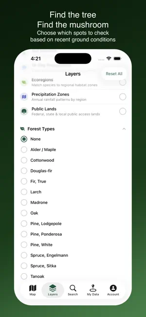

About Forayz
Find key opportunities for morels, boletes, chanterelles, and other popular mushrooms, and begin planning your next foray. Forayz is the mushroom foraging map built for serious hunters. Track wildfire burns, check soil conditions, and find the forest types that grow the mushrooms you're after. How foragers use Forayz: — Burn areas across the western US, filtered by fire year — Near real-time soil moisture, temperature and precipitation — Tap a spot for likely tree species and current conditions — Start free with an account — no payment required FREE WITH YOUR ACCOUNT • Soil temperature & moisture — regional view, surface and root zone • 7-day precipitation — see where it just rained • Snow cover — time your spring forays • Wildfire smoke — current, 1 and 2-day forecast • Active wildfires — track this year's fires for next year's morel zones • A sample year of past burns — one older fire season, free • Historical burns back to 2006 • Public lands, forest roads, trails and recreation sites • Ecoregions & rainfall normals • Town markers, with a preview of what Pro shows • GPS navigation, and full use of any waypoints and tracks you've already saved FORAYZ PRO • Recent burns — the two most recent fire seasons, with burn severity and prescribed burns • Timber harvests & disturbed forests — recently logged or thinned ground • Full-detail soil maps — zoom all the way in • 14 and 30-day precipitation • Recent snowmelt — a unique spring habitat • Tree species maps and forest maturity • Matsutake habitat (in season) • Town conditions & fruiting calendar — tap a town for soil, rain, snow and a month-by-month calendar of popular species • Save waypoints & record tracks — with GPX import and export • Offline maps — download areas including environmental, tree and satellite views Start free — upgrade to Forayz Pro when you're ready.
What’s new
Version 2.15.2 · Updated October 17, 2026
Wilderness areas stand out • With Public Lands on, wilderness areas now have a hatched fill and a solid border, so you can tell them apart from the national forest around them • Tap a wilderness area to see which forest it's within and a reminder to check picking rules before you go • With Public Lands off, a faint border still marks wilderness Offline maps • The download screen now estimates the size of the area you select • Satellite imagery can be included for areas up to about 1,500 square miles • Very large areas (over about 7,700 square miles) need to be downloaded in smaller pieces. The app asks you to zoom in when an area is too big Fixes • Pro map layers no longer disappear after the app has been open in the background for a day or more
App privacy
The developer, Salish Mushrooms. LLC, reported these privacy practices to Apple.
Data Linked to You
The following data, which may be collected and linked to your identity, may be used for the following purposes:
- Contact Info: Email Address, Name
- Identifiers: User ID
- Diagnostics: Crash Data
Used for: App Functionality
Alternatives to Forayz
Looking for apps like Forayz? Here are 6 similar apps on the App Store. The highest rated is FerryFriend (4.9/5), and all 6 are free to download.
-
 National Forests & Grasslands
4.7
-
 FerryFriend
4.9
-
 RockHoundR: Rockhounding Map
4.6
-
 Seattle Transit: Bus Tracker
4.7
-
 Whale Alert
4.7
-
 Campsite: Camping, RVs & Maps
4.8
| App | Rating | Price | Last updated | Compare |
|---|---|---|---|---|
| Forayz | 5.0 / 5 (3 ratings) | Free | October 17, 2026 | |
| National Forests & Grasslands | 4.7 / 5 (13) | Free | Sep 22, 2026 | Compare |
| FerryFriend | 4.9 / 5 (2,897) | Free | Oct 25, 2026 | Compare |
| RockHoundR: Rockhounding Map | 4.6 / 5 (140) | Free | Oct 10, 2026 | Compare |
| Seattle Transit: Bus Tracker | 4.7 / 5 (830) | Free | Oct 21, 2026 | Compare |
| Whale Alert | 4.7 / 5 (614) | Free | Oct 23, 2026 | Compare |
| Campsite: Camping, RVs & Maps | 4.8 / 5 (77) | Free | Oct 22, 2026 | Compare |
Compare Forayz with the top alternatives: ratings, updates, ASO score and keyword gaps →