

TrailLegs: GPS Thru-Hike Maps
Menno Lammerts van Bueren Navigation iPhoneiPadiPod touch
TrailLegs: GPS Thru-Hike Maps is a free Navigation app for iPhone and iPad by Menno Lammerts van Bueren. Rated 5.0/5 from 1 ratings. Requires iOS 16.4.
- Rating
- 5.0
- 1 ratings
- Price
- Free
- on the App Store
- Size
- 84 MB
- Age 4+
- Updated
- Sep 2
- 2026 · v2.5.0
Screenshots


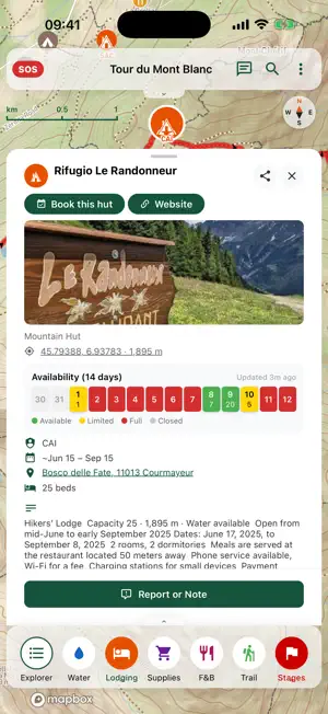
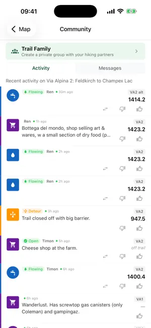
About TrailLegs: GPS Thru-Hike Maps
Why TrailLegs? The all-in-one app built by thru-hikers for thru-hikers with the best curated long-distance hikes. Trail-tested offline flexibility. Offline Flexibility Because you know most of the time there is no reception, and even if there is, you want to save your battery in airplane mode. And you'll probably start with a plan that becomes obsolete after a couple of days, due to weather, injury, wildfire closures, or whatever reason. So you need to be flexible and take it day by day. Features - Offline (3D) map with points of interest (POIs), like water sources, resupply points, huts (including occupation where available), camp spots, groceries, and many more. - Intuitive cross-hair with distance marker and measure tool, to plan your upcoming stage on the fly, including distance, total climb, and elevation screen. - Create/Import/Export custom deviations - Multi-day planning tool - Benefit from, and support other hikers on the same trail by adding waypoints and submitting reports & remarks to existing POIs. Online updates, stored for offline use. When you are online for a couple of minutes, you want to update and store relevant info for offline use during the days ahead. Features - weather forecasts & warnings by multi-stage and planned days, precipitation radar, snow depths, wildfires, guard dogs, trail closures, etc. - Benefit from, and support other hikers on the trail by adding waypoints and submitting reports & remarks to existing POIs (you are able to submit offline and will sync the next time you are online). - Create your own Trail Family and stay in touch with your trail buddies during your hiking day. Set a meeting point, see where your buddies are on the map, leave a message for them. Only the best thru-hikes and long-distance hikes Of course you know there are many navigation apps that offer trails, but you also know that most of them try to be everything for everyone, which just isn't for you, because you need to focus only on the best long-distance hikes. So you can just follow the red line without irrelevant features or distractions from other non-verified routes on your map. Features - Download from inside the app new and updated trails from Europe to New Zealand, including the new and classic Via Alpina, GR20, GR10/11/HRP, Tour du Mont Blanc (TMB), Walker's Haute Route, Tour des Combins, Kungsleden, West Highland Way (WHW), the US Triple Crown (PCT/CDT/AT), Te Araroa, and many more. For the full list, see: https://traillegs.app/trails.html. New routes added regularly (also on request). Subscription Plans - FREE OFFLINE MAP: Tour du Mont-Blanc (TMB) - FREE 7 DAY TRIAL WITH ALL TRAILS AND ALL PRO FEATURES. - Trail Access: €4.99/month or €9.99/year. All Trails with offline maps - Pro: €19.99/year. Adds trail measurement, Custom routes, Import/Export GPX, Planner, snow overlays, extended weather forecasts, rain radar, and setup trail family. Happy Trails! TrailLegs, More Miles, Less Hassle
What’s new
Version 2.5.0 · Updated September 2, 2026
Bug fixes
App privacy
The developer, Menno Lammerts van Bueren, reported these privacy practices to Apple.
Data Linked to You
The following data, which may be collected and linked to your identity, may be used for the following purposes:
- Contact Info: Email Address
- Health & Fitness: Fitness
- Location: Precise Location, Coarse Location
- User Content: Photos or Videos, Other User Content
- Identifiers: User ID, Device ID
Used for: Developer’s Advertising or Marketing, App Functionality
Data Not Linked to You
The following data, which may be collected but is not linked to your identity, may be used for the following purposes:
- Purchases: Purchase History
- Diagnostics: Crash Data, Performance Data, Other Diagnostic Data
Used for: App Functionality
Alternatives to TrailLegs: GPS Thru-Hike Maps
Looking for apps like TrailLegs: GPS Thru-Hike Maps? Here are 6 similar apps on the App Store. The highest rated is PermitPulse (4.2/5), and all 6 are free to download.
-
 Outpost - Alpine Huts
-
 Outlife: Outdoor Life
-
 Traverse: Backcountry Maps
-
 Montréal Metro REM Offline
-
 PermitPulse
4.2
-
 Explore Chapada
| App | Rating | Price | Last updated | Compare |
|---|---|---|---|---|
| TrailLegs: GPS Thru-Hike Maps | 5.0 / 5 (1 rating) | Free | September 2, 2026 | |
| Outpost - Alpine Huts | – | Free | Aug 5, 2026 | Compare |
| Outlife: Outdoor Life | – | Free | Mar 19, 2026 | Compare |
| Traverse: Backcountry Maps | – | Free | Oct 10, 2026 | Compare |
| Montréal Metro REM Offline | – | Free | Oct 1, 2026 | Compare |
| PermitPulse | 4.2 / 5 (5) | Free | Aug 8, 2026 | Compare |
| Explore Chapada | – | Free | Sep 28, 2024 | Compare |