

RiverTrax: River Levels & Flow
TraxLabs LLC Weather iPhoneiPadiPod touch
RiverTrax: River Levels & Flow is a free Weather app for iPhone and iPad by TraxLabs LLC. Rated 4.6/5 from 5 ratings. Requires iOS 16.0.
- Rating
- 4.6
- 5 ratings
- Price
- Free
- on the App Store
- Size
- 193 MB
- Age 4+
- Updated
- Sep 20
- 2026 · v1.8
Screenshots


About RiverTrax: River Levels & Flow
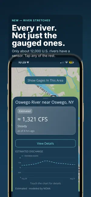
Rivers and streams can change by the hour. RiverTrax tells you what yours is doing right now — and what it's about to do. EVERY RIVER, NOT JUST THE FAMOUS ONES About 12,700 U.S. gauges get an official National Weather Service forecast. Another 4,300 report live data without one. Most moving water has no sensor at all. RiverTrax covers all three — and always tells you which one you're looking at. Gauged and forecast. Live level, discharge, flood stage and trend, plotted alongside the official NWS forecast. Gauged, live only. Thousands of smaller creeks and tributaries sit outside the forecast inventory. You get live readings, history, trend, water temperature where it's reported, and alerts — no forecast line or flood stage, because there isn't one. No gauge at all. The creek behind your house, the section below the dam, the gorge run. An estimate modeled by NOAA, updated hourly. Just like you don't need a weather station in your backyard to get a forecast, the same is true for rivers. RIVER STRETCHES Tap any river or creek on the map. Name it your way: "Below the dam," "The gorge section." See its estimated flow right now, which way it's trending, and a 10-day outlook. Save it next to your favorite gauges and watch it the same way. Stretch conditions come from NOAA's National Water Model, the federal system that simulates flow on every river and creek in the country. Estimates are always labeled Estimated, attributed to NOAA, and marked with ≈. WE TELL YOU WHEN WE'RE LESS SURE A big river running steadily gets a number. A small creek, or water a storm is pushing around, gets a range — what the model can honestly support there. And when the model's output can't be trusted, RiverTrax says "estimate unavailable" instead of showing you a confident wrong number. FOR ANGLERS When steelhead push in on a fall rain, the question is always the same: has it dropped back into shape yet? Watch discharge, water temperature and trend on your tributaries, set your fishable range, and let Sweet Spot Alerts tell you the day it comes back down, instead of driving out to look. FOR KAYAKERS & RAFTERS See current discharge and whether it's rising or falling. Set your ideal flow range and let Sweet Spot Alerts tell you when conditions are lining up, before you drive to the put-in. Set a good range on a stretch and see it shaded right on the 10-day chart. FEATURES Find Your Water Search any gauge or creek by name or USGS site number. Save it and it pins on your map — every favorite, always, wherever the map is pointed. Charts You Can Actually Read Observed discharge plotted alongside official NWS forecasts on a clean timeline. Flood stage thresholds — Major, Moderate, Minor, Action — are marked right on the chart. Tap once for the 10-day outlook. Alerts That Look Ahead Set your ideal flow or gauge height range and RiverTrax watches the forecast, telling you when your window is coming days ahead — not the morning of. Set hard thresholds for flood stage, CFS, gauge height, or rate of rise, and it watches those too. Your Rivers on Your Home Screen Pin favorite gauges to your iPhone home screen. Live discharge, gauge height, and trend at a glance — no app open required. Follow the River Jump straight to the next gauge upstream or downstream, and see every stretch in between. River Journal — Only on RiverTrax Write a note on any gauge or stretch and RiverTrax stamps it with the conditions at that moment — discharge, gauge height, rate of change. Build a record of what flows fished or paddled well. How This Works A plain-language explainer built in: where every number comes from, what a gauge measures, how a stretch is estimated, and how far to trust each. NO ADS. NO ACCOUNT. NO SETUP. Open it, find your water, go. River data provided by USGS and NOAA. Estimates and extended outlooks are model output, not official forecasts. Not intended for navigation or safety-of-life decisions. Always consult official sources and use good judgment.
Ratings & reviews
4.6
5 ratings
What’s new
Version 1.8 · Updated September 20, 2026
Thousands more gauges are now in RiverTrax. Some USGS stations aren't in the National Weather Service forecast inventory — plenty of smaller creeks and tributaries fall into that gap. Those gauges now work in RiverTrax as observation-only stations: live readings and history, just without a forecast line on the chart. Alerts work on them too. Set your threshold and RiverTrax will let you know when a creek comes up or drops into range, same as any other gauge. — John
App privacy
The developer, TraxLabs LLC, reported these privacy practices to Apple.
Data Not Collected
The developer does not collect any data from this app.
Alternatives to RiverTrax: River Levels & Flow
Looking for apps like RiverTrax: River Levels & Flow? Here are 6 similar apps on the App Store. The highest rated is Flow Now-River Levels Widget (5.0/5), and all 6 are free to download.
-
 Flow Now-River Levels Widget
5.0
Flow Now-River Levels Widget
5.0
-
 Riffle: River Gauges & Weather
4.3
Riffle: River Gauges & Weather
4.3
-
 River Stages-USA
4.8
River Stages-USA
4.8
-
 Rivers.run - River Levels
4.4
Rivers.run - River Levels
4.4
-
 Blue Liner Flows
4.7
Blue Liner Flows
4.7
-
 RiverAware
5.0
RiverAware
5.0
| App | Rating | Price | Last updated |
|---|---|---|---|
| RiverTrax: River Levels & Flow | 4.6 / 5 (5 ratings) | Free | September 20, 2026 |
| Flow Now-River Levels Widget | 5.0 / 5 (3) | Free | Aug 6, 2026 |
| Riffle: River Gauges & Weather | 4.3 / 5 (13) | Free | Sep 16, 2026 |
| River Stages-USA | 4.8 / 5 (11) | Free | Sep 22, 2025 |
| Rivers.run - River Levels | 4.4 / 5 (30) | Free | Jun 30, 2026 |
| Blue Liner Flows | 4.7 / 5 (41) | Free | Mar 5, 2026 |
| RiverAware | 5.0 / 5 (9) | Free | Dec 15, 2025 |