
AvWx
AvWx, LLC Weather iPhoneiPadiPod touch
AvWx is a free Weather app for iPhone and iPad by AvWx, LLC. Rated 4.5/5 from 8 ratings. Requires iOS 18.2. Updated September 5, 2026.
- Rating
- 4.5
- 8 ratings
- Price
- Free
- on the App Store
- Size
- 74 MB
- Age 4+
- Updated
- Sep 5
- 2026 · v5.3
Screenshots


About AvWx
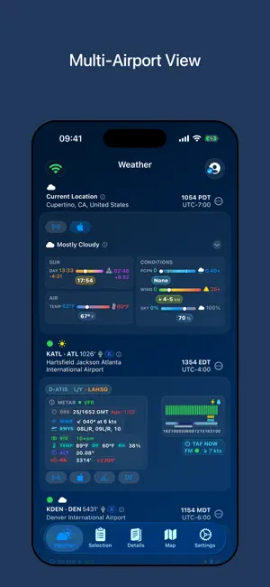
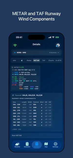
Situational awareness for pilots and dispatchers — every airport you care about, on one screen. AvWx pulls AviationWeather.gov, NOAA radar, FAA advisories, Digital ATIS, NWS alerts and Apple Weather into a single operational picture, so you can read a whole day of flying without opening five apps. THE TAF TIMELINE Every TAF drawn on one time axis, instead of read as a wall of code. • Overlapping conditional groups made obvious — TEMPO and PROB sit in their own band beneath the prevailing periods, so you can see at a glance exactly which hours they cut across • Runway wind components for every forecast period, not just for the current METAR — head and crosswind for each end as the wind shifts through the day • Apple Weather's hourly precipitation overlaid on the same axis — type, intensity and chance, hour by hour, so a second independent forecast reads directly against the TAF's own periods • Flight category, visibility, ceiling and present weather as coloured bars you can read in a second • The current METAR and the current time overlaid, anchoring the forecast to what is actually happening • Day, night and twilight bands with moon visibility behind the whole timeline • Alternate requirements and likely runway configuration changes flagged as they arrive WHAT SETS IT APART • Every airport side by side — METAR, TAF, radar and advisories for all of them at once, no switching back and forth • Live radar on every airport tile, plus the nearest cell's distance and bearing • Advisories that actually reach you — SIGMETs, CWAs and NWS alerts matched to your airport's position, not just its region • See when another airport's Ground Stop or Ground Delay Program is holding your departure, with the ARTCC centers it covers shaded on a map FREE • Up to five airports • METAR and TAF, decoded and clearly formatted • The full TAF timeline, in airport local time or UTC • FAA advisories and SIGMET/CWA alerts, with live countdowns PREMIUM Unlimited airports and everything below. One-week free trial, and it removes ads. MAPS & RADAR • Radar reflectivity, echo tops and precipitation type, with an animated loop • Nationwide NWS alert regions, colour-coded by product, with storm motion vectors • Airspace overlays — tap any boundary to identify it • Wildfire smoke in two layers — satellite-observed plumes, which include smoke aloft, and a separate near-surface forecast • Satellite imagery, including a zoom straight to any runway end WEATHER DEPTH • Extended Apple Weather forecasts, hourly and daily • Minute-by-minute next-hour precipitation with a rising, steady or falling trend • Density altitude, heat index, and forecast against historical normals • Sun and moon events, twilight bands, moon phase and visibility OPERATIONS • Favored runways and wind components for the current METAR, with short-runway filtering • Decoded D-ATIS beside the raw broadcast — approaches and runways in use, wind shear, PRM, CAT II/III • Saved locations beyond airports — home, layover cities, anywhere — with full forecasts • Cloud-synced airport lists, offline-aware, with connection status and last-sync time BUILT FOR Pilots working tight turns. Dispatchers watching many stations at once. International crews managing alternates, ETOPS, driftdown and redispatch. Anyone who needs to see evolving weather across a lot of airports, quickly. An in-app Guide and symbol Legend explain every bar, glyph and colour, so nothing on screen is a mystery. AvWx is a professional supplement, not a replacement for certified flight-planning tools. Optimized for iPad. Terms of Use: https://www.apple.com/legal/internet-services/itunes/dev/stdeula/ Privacy Policy: https://avwxllc.github.io/privacy-policy.md
Ratings & reviews
4.5
8 ratings
What’s new
Version 5.3 · Updated September 5, 2026
• Favorites: star any airport to set it aside for a trip or a day, then select or replace your whole watch list in one tap. • Search on the Map and Details tabs: type an ICAO, IATA, GPS or local code and jump straight to that airport, saved or not, and save it from the result. • The Details tab shows any searched airport in place, with an Options menu for Map, Save, Select and Favorite. • Choose which tab the station view opens on (Settings ▸ Station View). • US airspace now comes from the FAA NASR data in the airport database, with a separate International Airspace layer, so nothing draws twice at the border. • ARTCC boundaries: new High and Low center layers, labeled along their edges. • Airport database updates now include every reporting weather station (buoys, platforms, mesonet sites) with its time zone. • Density altitude accounts for humidity, and the METAR tab shows how pressure, temperature and humidity each contribute to the total. • New Density Altitude range bar under Pressure, linked to its chart. • Cloud bases in MSL on the METAR tab beside AGL, for approach charts. • TAF NOW looks one hour ahead. Permanently closed runways are never favored. • Helipad labels are off by default on satellite views. • Fixed runway wind components going blank after a station reported no wind. • Fixed the TAF timeline's sun and moon bars showing an outdated window after a TAF reissue. • Fixed a Gulf of Mexico weather station being matched to an airport in Papua New Guinea. • Fixed search results closing or clearing when they should stay put. • Losing connectivity never removes data: everything stays on screen with its age shown.
App privacy
The developer, AvWx, LLC, reported these privacy practices to Apple.
Data Used to Track You
The following data may be used to track you across apps and websites owned by other companies:
- Identifiers: Device ID
Data Linked to You
The following data, which may be collected and linked to your identity, may be used for the following purposes:
- Contact Info: Email Address, Name
- Location: Coarse Location
Used for: Developer’s Advertising or Marketing, Analytics, Other Purposes
Data Not Linked to You
The following data, which may be collected but is not linked to your identity, may be used for the following purposes:
- Identifiers: Device ID
- Usage Data: Product Interaction, Advertising Data, Other Usage Data
Used for: Third-Party Advertising, Analytics
Alternatives to AvWx
Looking for apps like AvWx? Here are 6 similar apps on the App Store. The highest rated is NimboStratusAI (5.0/5), and all 6 are free to download.
-
 Thermometer - Weather Live pro
-
 NimboStratusAI
5.0
NimboStratusAI
5.0
-
 Airops Aero
-
 Aviation Weather: METAR, TAF
4.3
Aviation Weather: METAR, TAF
4.3
-
 Weather Wizard : 14D Forecast
4.8
Weather Wizard : 14D Forecast
4.8
-
 Orion Maps
2.0
Orion Maps
2.0
| App | Rating | Price | Last updated | Compare |
|---|---|---|---|---|
| AvWx | 4.5 / 5 (8 ratings) | Free | September 5, 2026 | |
| Thermometer - Weather Live pro | – | Free | Jul 13, 2026 | Compare |
| NimboStratusAI | 5.0 / 5 (7) | Free | Jun 5, 2026 | Compare |
| Airops Aero | – | Free | Apr 6, 2026 | Compare |
| Aviation Weather: METAR, TAF | 4.3 / 5 (13) | Free | Jul 16, 2026 | Compare |
| Weather Wizard : 14D Forecast | 4.8 / 5 (27) | Free | Sep 26, 2026 | Compare |
| Orion Maps | 2.0 / 5 (4) | Free | Sep 27, 2026 | Compare |
Compare AvWx with the top alternatives: ratings, updates, ASO score and keyword gaps →