
American Palette
Christopher Elliott Travel iPhoneiPadiPod touch
American Palette is a paid Travel app for iPhone and iPad by Christopher Elliott. Rated 5.0/5 from 5 ratings. Requires iOS 17.6. Updated August 2, 2026.
- Rating
- 5.0
- 5 ratings
- Price
- 19.99 USD
- on the App Store
- Size
- 11 MB
- Age 4+
- Updated
- Aug 2
- 2026 · v2.3.1
Screenshots

About American Palette
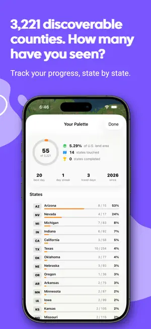
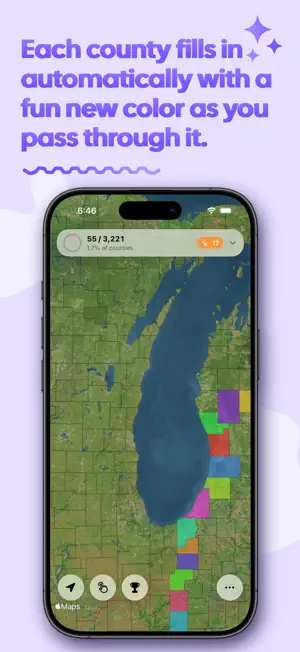
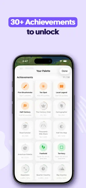
There are more than 3,143 discoverable counties in the United States. Most people see a few dozen in a lifetime and never notice. American Palette notices. Leave it running while you travel. The moment you cross a county line, that county fills in with its own color, numbered in the order you found it. No check-ins. No buttons to press. You just drive, fly, or scooter, and the map slowly becomes a picture of everywhere you've been. Every county now gets a color chosen so that back-to-back discoveries never look alike, the result is a map that reads as a color palette Flying somewhere and it missed a few counties? Retracing an old trip? Switch on manual mode and tap any county to add it with the visit number you choose. Everything after it renumbers itself. Long-press any county to see when you found it, or remove it if you marked one by mistake. - Progress for all 50 states, with completed states called out - The exact percentage of U.S. land area you've covered - Best day, longest streak, total travel days, and when you started - 30 achievements across four categories, each one telling you plainly what it takes to unlock and exactly how close you are One tap builds an image of your painted map with your numbers underneath and your color palette running along the bottom. Save it or post it. YOUR DATA, YOUR DEVICE Nothing is uploaded. There's no account, no sign-in, and no server. Your counties live on your phone. Export everything to a JSON file whenever you want, and import it back on a new device. We take privacy and security extremely seriously. County boundaries are bundled with the app, so tracking keeps working with no cellular/internet signal at all — through the Nevada basin, across west Texas, up the Alaska Highway. MADE FOR THE ROAD - Three map styles: satellite, satellite with labels, and a minimal basemap that lets the colors carry - County borders on or off - The discovery chime mixes with your music and follows the ring/silent switch — it will never interrupt navigation or a podcast - Battery-aware location tracking that tightens up near a county line and relaxes in the middle of one Whether you're a county collector working toward all 3,143, a road tripper who wants a record of the long way home, or someone who just wants to see how much of the country they've actually touched — the map is waiting. Continued use of GPS running in the background can dramatically decrease battery life. Look for the blew navigation arrow on when the app is not in focus to confirm that the app is still tracking location in the background. Force quit when you no longer wish to use it to save battery life.
Ratings & reviews
5.0
5 ratings
What’s new
Version 2.3.1 · Updated August 2, 2026
IMPROVED BATTERY PERFORMANCE By engineering an intelligent GPS mode that increases polling rates near county borders and reduces them when you aren't near any (or when stationary), we are able to achieve an average of 20% or more decrease in battery drain over the previous versions while still maintaining a responsive user experience. SHARE YOUR MAP A new share button in the stats screen builds an image of your painted counties with your totals underneath and your full color palette along the bottom. Save it or post it. ACHIEVEMENTS Every achievement now tells you plainly what it takes to unlock, how far along you are, and what's left to do. They're grouped into Milestones, Land Area, States, and Journeys, and you can filter to just the ones still in progress. A CHIME FOR NEW COUNTIES Crossing into a new county now plays a short chime alongside the usual buzz. It mixes with whatever you're already listening to, follows your ring/silent switch, and can be switched off in the ••• menu. ALSO IN THIS UPDATE - Counties that surround an independent city — Richmond, Baltimore City, St. Louis and others — now draw correctly with the city cut out - Noticeably faster launches after the first one - Visit numbers on multi-part counties now sit on the main body instead of drifting onto a small island - Importing a backup is more reliable, and failures now tell you what went wrong instead of failing quietly - Your map style and border setting are remembered between launches - Renumbering after removing a county now updates the "recently discovered" list right away - Full VoiceOver labels throughout, and a Done button on the visit-order keyboard - Exported filenames are cleaner and easier to work with
App privacy
The developer, Christopher Elliott, reported these privacy practices to Apple.
Data Not Linked to You
The following data, which may be collected but is not linked to your identity, may be used for the following purposes:
- Identifiers: User ID, Device ID
- Diagnostics: Crash Data, Performance Data
- Location: Precise Location
- Usage Data: Product Interaction
Used for: Analytics, App Functionality
Alternatives to American Palette
Looking for apps like American Palette? Here are 6 similar apps on the App Store. The highest rated is Mycel — Foraging Map & Journal (5.0/5), and 5 of the 6 are free to download.
-
 LensPro - Privacy Guard
-
 Travel Routes: Map Animation
4.0
Travel Routes: Map Animation
4.0
-
 TravelVocab: Travel Phrases
-
 County Names & Lines
4.3
County Names & Lines
4.3
-
 Lewis & Clark Trail Experience
4.9
Lewis & Clark Trail Experience
4.9
-
 Mycel — Foraging Map & Journal
5.0
Mycel — Foraging Map & Journal
5.0
| App | Rating | Price | Last updated |
|---|---|---|---|
| American Palette | 5.0 / 5 (5 ratings) | 19.99 USD | August 2, 2026 |
| LensPro - Privacy Guard | – | Free | Jun 13, 2026 |
| Travel Routes: Map Animation | 4.0 / 5 (2) | 0.99 USD | Sep 14, 2026 |
| TravelVocab: Travel Phrases | – | Free | Feb 18, 2026 |
| County Names & Lines | 4.3 / 5 (26) | Free | Sep 18, 2026 |
| Lewis & Clark Trail Experience | 4.9 / 5 (41) | Free | Jul 13, 2026 |
| Mycel — Foraging Map & Journal | 5.0 / 5 (1) | Free | Sep 18, 2026 |