

GTag: GPS Map Camera
Devang Kunjadiya Navigation iPhoneiPadiPod touch
GTag: GPS Map Camera is a free Navigation app for iPhone and iPad by Devang Kunjadiya. Rated 5.0/5 from 3 ratings. Requires iOS 15.0.
- Rating
- 5.0
- 3 ratings
- Price
- Free
- on the App Store
- Size
- 77 MB
- Age 4+
- Updated
- Oct 6
- 2026 · v1.5.4
Screenshots



About GTag: GPS Map Camera
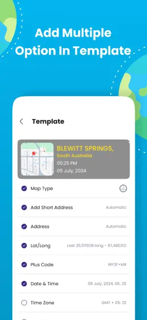
Key Features: - GPS Location Stamps: Add latitude, longitude, altitude, and address stamps directly to your photos. - Date & Time Stamps: Automatically include the exact date and time of capture. - Customizable Styles: Choose from various stamp styles and formats to suit your needs. - Geotag Sharing: Easily share your location-stamped photos with family and friends to highlight your travels and movements. The GPS Map Camera App is your ultimate tool for combining photography with precise geolocation details. Here’s why it’s a must-have for your smartphone: Satellite Map Stamps: Add detailed satellite map overlays directly to your photos. GPS Location Stamps: Automatically embed GPS coordinates, including longitude, latitude, and address, onto your pictures. Photo Location Stamps: Document the exact location where each photo was captured. Date & Time Stamps: Keep a precise record of when each memory was made. Comprehensive Data: Add a complete suite of details, including longitude, latitude, address, date, time, and location. Geo Location Image Stamps: Highlight your travel memories with unique geo-location markers. Capture your adventures with precision using the GPS Map Camera With GPS Map Camera, every photo becomes a story of where you’ve been. Download now and make your travel memories unforgettable! GPS Location, timestamp, gps camera, time stamp camera, GPS camera map, Geo tag, Free GPS Location, notecam, timestamp camera basic,hunting app, timestamp camera, time mark Terms of Use :- https://ardrawingpaint.blogspot.com/2024/12/terms-of-use-gpscameramap.html Privacy Policy :- https://ardrawingpaint.blogspot.com/2024/12/subscriptions-policy-gpscameramap.html
What’s new
Version 1.5.4 · Updated October 6, 2026
- improved app stability
App privacy
The developer, Devang Kunjadiya, reported these privacy practices to Apple.
Data Used to Track You
The following data may be used to track you across apps and websites owned by other companies:
- Usage Data: Advertising Data
Data Not Linked to You
The following data, which may be collected but is not linked to your identity, may be used for the following purposes:
- Usage Data: Advertising Data
- Diagnostics: Crash Data
Used for: Third-Party Advertising, Analytics, App Functionality
Alternatives to GTag: GPS Map Camera
Looking for apps like GTag: GPS Map Camera? Here are 6 similar apps on the App Store. The highest rated is Acre Bound: Property Lines Map (4.2/5), and all 6 are free to download.
-
 GeoTag Camera Timestamp
3.6
-
 Compass & Location Tracker
4.1
-
 Smart GPS Navigation & Maps
-
 Acre Bound: Property Lines Map
4.2
-
 Phone Tracker - Family Tracker
2.0
-
 GPS Maps Camera
3.9
| App | Rating | Price | Last updated | Compare |
|---|---|---|---|---|
| GTag: GPS Map Camera | 5.0 / 5 (3 ratings) | Free | October 6, 2026 | |
| GeoTag Camera Timestamp | 3.6 / 5 (5) | Free | Sep 19, 2026 | Compare |
| Compass & Location Tracker | 4.1 / 5 (12) | Free | Sep 29, 2026 | Compare |
| Smart GPS Navigation & Maps | – | Free | Sep 10, 2026 | Compare |
| Acre Bound: Property Lines Map | 4.2 / 5 (17) | Free | Sep 6, 2026 | Compare |
| Phone Tracker - Family Tracker | 2.0 / 5 (3) | Free | Aug 11, 2026 | Compare |
| GPS Maps Camera | 3.9 / 5 (7) | Free | Oct 7, 2026 | Compare |