
Live Street View Earth Map
Muhammad Uzair Ajmal Travel iPhoneiPadiPod touch
Live Street View Earth Map is a free Travel app for iPhone and iPad by Muhammad Uzair Ajmal. Rated 3.3/5 from 16 ratings. Requires iOS 16.6.
- Rating
- 3.3
- 16 ratings
- Price
- Free
- on the App Store
- Size
- 49 MB
- Age 4+
- Updated
- Sep 5
- 2025 · v1.6
Screenshots


About Live Street View Earth Map
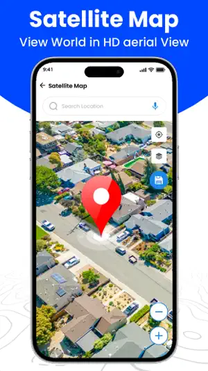
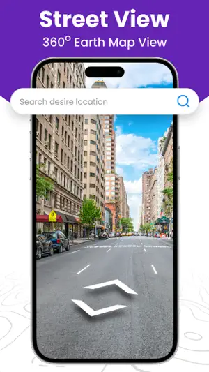
Modern mapping tools have transformed how we navigate, explore, and plan our daily activities. Features like Route Navigation Provides step-by-step directions to guide users to their destination efficiently. Live Street View Earth Map Offers real-time views of streets and landmarks from around the world, enhancing the map experience. Street View Displays 360-degree imagery of streets, giving users a realistic view of locations. Current Location Identifies the user’s exact position on the map, ensuring better navigation and route accuracy. and Area Measurement This allows users to measure the area of specific regions on the map, helpful for planning and analysis. As technology continues to advance, these features will likely evolve further, offering even more interactive and user-friendly experiences tailored to specific needs and preferences. Features: Live Street View Earth Map: Live Street View Earth Map offers a panoramic, street-level visualization of various locations, allowing users to virtually explore cities, neighborhoods, and landmarks. Map Streetview It provides a realistic 3D experience where users can look around in all directions, "walk" through streets, and view locations as if they were there. The Street View feature is handy for previewing a place before visiting, giving users a sense of familiarity with the area. GPS route navigation: Route Navigation tools help users find the most efficient way to reach their destination by providing turn-by-turn directions. Users can select their preferred route based on travel modes, such as driving, walking, biking, or public transportation. The Route navigation system updates in real-time to suggest alternative routes, considering factors like traffic, road closures, and accidents to ensure the fastest or most convenient journey. Satellite View in Real Time: Satellite View Live provides an overhead, high-resolution image of the Earth's surface captured by Satellite View Live Earth Maps. It lets users observe natural landscapes, terrain, and urban areas in detail. Unlike traditional maps, Satellite View imagery includes real-world visuals, showing buildings, vegetation, water bodies, and other features as they appear from above, providing a more realistic view. Current Location: The current location app feature identifies and displays the user’s real-time position on the map, marked by a pinpoint icon. By enabling GPS or location services on their device, users can track their movements as they navigate, which is especially useful for finding nearby amenities, or reorienting if lost. It updates automatically, allowing users to remain aware of their surroundings at all times. Area Measurement: Area Measurement tools allow users to measure the area or perimeter of a selected region on the map. By marking points along the boundaries of a property, park, or any geographic space, users can calculate the total area in various units (square meters, hectares, etc.). This is particularly valuable for real estate planning, agricultural purposes, and land management. Save Address: Save Address lets users bookmark important or frequently visited locations, such as home, work, or favorite spots. By saving addresses, users can quickly access these places later without needing to search for them each time. It is ideal for users who often return to specific locations or need easy access to important addresses for convenience. Each of these features adds significant value to map-based applications by enhancing the user’s ability to explore, navigate, and interact with the world.
Ratings & reviews
3.3
16 ratings
What’s new
Version 1.6 · Updated September 5, 2025
Make some UI Updates App Performance Improved
App privacy
The developer, Muhammad Uzair Ajmal, reported these privacy practices to Apple.
Data Used to Track You
The following data may be used to track you across apps and websites owned by other companies:
- Diagnostics: Performance Data
Data Not Linked to You
The following data, which may be collected but is not linked to your identity, may be used for the following purposes:
- Identifiers: Device ID
- Diagnostics: Performance Data
- Location: Precise Location
Used for: Third-Party Advertising, Analytics, App Functionality
Alternatives to Live Street View Earth Map
Looking for apps like Live Street View Earth Map? Here are 6 similar apps on the App Store. The highest rated is Lite Maps: 3D & Street View (4.6/5), and all 6 are free to download.
-
 StreetUp: Live Earth View
3.5
-
 Lite Maps: 3D & Street View
4.6
-
 Live Earth Map & GPS Map
4.6
-
 Live Earth Map - Live Camera
4.1
-
 Live Satellite View & Maps
2.9
-
 Globe 3D Earth: World Map Live
4.1
| App | Rating | Price | Last updated | Compare |
|---|---|---|---|---|
| Live Street View Earth Map | 3.3 / 5 (16 ratings) | Free | September 5, 2025 | |
| StreetUp: Live Earth View | 3.5 / 5 (2) | Free | Sep 16, 2026 | Compare |
| Lite Maps: 3D & Street View | 4.6 / 5 (161) | Free | Oct 11, 2026 | Compare |
| Live Earth Map & GPS Map | 4.6 / 5 (99) | Free | Aug 24, 2025 | Compare |
| Live Earth Map - Live Camera | 4.1 / 5 (120) | Free | May 12, 2025 | Compare |
| Live Satellite View & Maps | 2.9 / 5 (36) | Free | May 23, 2025 | Compare |
| Globe 3D Earth: World Map Live | 4.1 / 5 (76) | Free | Aug 24, 2026 | Compare |