

Boston Guide and Subway map
Yaroslav Mykolaienko Travel iPhoneiPadiPod touch
Boston Guide and Subway map is a free Travel app for iPhone and iPad by Yaroslav Mykolaienko. Requires iOS 17.0. Updated September 23, 2026.
- Price
- Free
- on the App Store
- Size
- 93 MB
- Age 4+
- Updated
- Sep 23
- 2026 · v2.0
Screenshots


About Boston Guide and Subway map
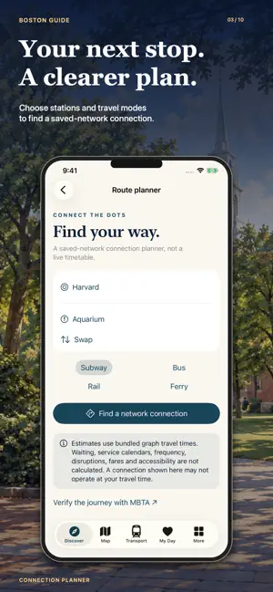
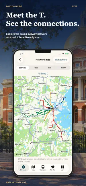
Discover Boston through historic streets, waterfront views, museums and green spaces. Boston City Guide 2027 brings 41 places, seven walking ideas, a Freedom Trail passport, MBTA maps and a day planner together on your iPhone and iPad. Walk from Boston Common to Charlestown, pause in the Public Garden or leave an afternoon for art. Build your itinerary around the places that interest you. 41 PLACES TO DISCOVER Explore sights, museums, parks, neighbourhoods, cafes, restaurants, bars and live music. Browse nine area groups covering Boston and Cambridge, search for a place and see it on the city map. Each place offers descriptions, highlights, visit notes, access information and an official website link. Original illustrations introduce the city. Official links help you check hours, admission and bookings. Discover Fenway Park, the Museum of Fine Arts, Isabella Stewart Gardner Museum and Boston Public Library. Explore Beacon Hill, the North End and the Seaport, or plan time across the Charles River around Harvard Yard and Harvard Square in Cambridge. YOUR 16-SITE FREEDOM TRAIL PASSPORT Explore the historic sites from Boston Common and the Massachusetts State House to Paul Revere House, Old North Church, USS Constitution and Bunker Hill Monument. Mark each site as visited and keep your progress saved on your device. Choose the full historic-site sequence or take it in two shorter chapters: the Common to Faneuil Hall, and the North End to Charlestown. Read about each stop and add places to My Day. Apple Maps walking directions may differ from the official red-line trail, so follow official wayfinding when walking the Freedom Trail. Individual sites have separate admission and access arrangements. SEVEN WALKING IDEAS, YOUR OWN PACE Alongside the Freedom Trail and its two shorter chapters, explore the green heart of Boston, a harbour afternoon, Back Bay and the museums, or Beacon Hill at a slower pace. Read practical notes, calculate walking directions through Apple Maps and adapt the suggested stops to your interests. Combine a museum with a meal or pause beside the water. New walking routes require internet access. PARKS, GARDENS AND WATERSIDE MOMENTS Discover Boston Common, the Public Garden, Charles River Esplanade and Rose Kennedy Greenway. Explore eight discovery pins around the Common and Garden, read short introductions and add a park stop to your day. Find harbour and island planning information, with ferry and visitor links. Island outings have their own seasonal schedules and booking arrangements; check your outward and return journeys before setting off. MBTA MAPS AND CONNECTION IDEAS Browse a saved transport network with 183 routes and 7,331 stop records covering subway, bus, commuter rail and ferry services. Explore route shapes and the stops served, or use the local connection planner for an idea of how places connect. Planner results use stored transport data and travel estimates. They do not account for current departures, service calendars, reliable waiting times or disruptions. Confirm your journey with the official MBTA planner and current service information. Find Logan Airport guidance and official links for your arrival and onward connection. MAKE YOUR OWN BOSTON DAYS Create multiple days in My Day, save places, reorder stops and add notes. Adjust visit durations to leave room for lunch, a gallery or an unhurried walk. Your plans and passport progress stay saved locally. FOOD, EVENINGS AND PRACTICAL HELP Browse Eat & Night for cafes, restaurants, bars and music. Find city weather, local time and travel essentials, plus links for tours, tickets, car hire and mobile data through external providers. Place text, illustrations, the transport network and saved days are available locally. Maps, new walking directions, weather and external services need internet. This independent guide contains advertising and is not affiliated with MBTA or the attractions featured. Make your next Boston day your own.
What’s new
Version 2.0 · Updated September 23, 2026
- Updated app design. - Updated advertising. - Updated maps.
App privacy
The developer, Yaroslav Mykolaienko, reported these privacy practices to Apple.
Data Used to Track You
The following data may be used to track you across apps and websites owned by other companies:
- Location: Coarse Location
Data Not Linked to You
The following data, which may be collected but is not linked to your identity, may be used for the following purposes:
- Location: Coarse Location
Used for: Other Purposes
Alternatives to Boston Guide and Subway map
Looking for apps like Boston Guide and Subway map? Here are 6 similar apps on the App Store. The highest rated is Boston Walking Audio Tours (4.9/5), and all 6 are free to download.
-
 Boston Subway Guide
4.7
Boston Subway Guide
4.7
-
 Boston - Freedom Trail
4.0
Boston - Freedom Trail
4.0
-
 Boston & Salem Walking Tours
4.4
Boston & Salem Walking Tours
4.4
-
 Boston Travel Guide .
4.7
Boston Travel Guide .
4.7
-
 Only In Boston
4.8
Only In Boston
4.8
-
 Boston Walking Audio Tours
4.9
Boston Walking Audio Tours
4.9
| App | Rating | Price | Last updated |
|---|---|---|---|
| Boston Guide and Subway map | – | Free | September 23, 2026 |
| Boston Subway Guide | 4.7 / 5 (15) | Free | Jun 5, 2026 |
| Boston - Freedom Trail | 4.0 / 5 (1) | Free | Nov 4, 2025 |
| Boston & Salem Walking Tours | 4.4 / 5 (7) | Free | Sep 1, 2026 |
| Boston Travel Guide . | 4.7 / 5 (292) | Free | Sep 13, 2026 |
| Only In Boston | 4.8 / 5 (723) | Free | Mar 31, 2025 |
| Boston Walking Audio Tours | 4.9 / 5 (8) | Free | May 29, 2025 |