

Timelapse Map:Purple Satellite
Purple Geospatial Inc. Education iPhoneiPadiPod touchMac
Timelapse Map:Purple Satellite is a free Education app for iPhone and iPad by Purple Geospatial Inc. Rated 3.0/5 from 3 ratings. Requires iOS 18.0.
- Rating
- 3.0
- 3 ratings
- Price
- Free
- on the App Store
- Size
- 156 MB
- Age 4+
- Updated
- May 5
- 2026 · v2026.05.04
Screenshots

About Timelapse Map:Purple Satellite
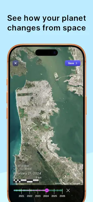
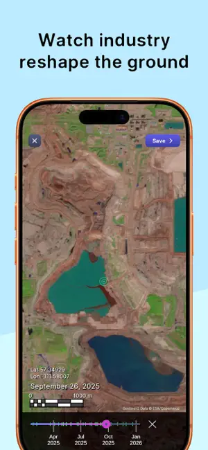
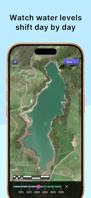
Purple Satellite lets you scrub time with your finger and watch the planet change. Slide through years of real satellite imagery. Cities grow, mines expand, forests disappear, coastlines shift. No timelines to configure. No layers to babysit. Just touch, drag, and see Earth evolve in front of you. Here are six exciting reasons to start looking at satellite images: Coastlines and Beaches: See how our beautiful coastlines and beaches change over time. You can observe the ebb and flow of tides, the impact of storms, and even the effects of human activities like building and conservation efforts. Urban Growth: Watch cities grow and evolve! Satellite images can show how urban areas expand, new neighborhoods pop up, and green spaces are preserved or developed. It’s like seeing the heartbeat of human civilization. Forests and Green Spaces: Explore the lush greenery of forests and parks. You can track how forests grow, recover from fires, or change with the seasons. It’s a great way to appreciate the resilience and beauty of nature. Water Bodies: From lakes and rivers to oceans, satellite images let you see the shimmering blue of our planet’s water bodies. You can observe changes in water levels, the health of coral reefs, and even the movement of glaciers. Agricultural Patterns: Discover the patchwork quilt of farmlands. Satellite images can show how crops are planted, harvested, and rotated. It’s fascinating to see how agriculture adapts to different climates and seasons. The Power of Nature: Witness the dynamic forces of nature, like volcanic eruptions, hurricanes, and the shifting of tectonic plates. These images highlight the incredible power and beauty of our planet’s natural processes. Key Features: Real-Time Geospatial Data: Access and analyze real-time geospatial data directly from your mobile device. User-Friendly Interface: Navigate through a sleek and intuitive interface designed for ease of use. Advanced Analytics: Utilize powerful shortwave infrared analytics tools to gain insights and make informed decisions. (In-app purchase required). Stay Updated: We regularly update our app to bring you the latest features and improvements. Keep an eye on our updates to make the most out of Purple Satellite. Contact Us: For any questions or concerns regarding the app, please reach out to us at [email protected]. Download Purple Satellite today and elevate your geospatial capabilities! Purple Satellite includes both a free version and a subscription plan, "Purple Satellite Pro", with access to additional features including visualization of High Dynamic Range (HDR) imagery, and filtering of images to remove snow-covered dates from timelapses. You can subscribe and pay on the App Store, using your Apple ID. Payment will be charged to your Apple ID at confirmation of purchase. Your subscription will automatically renew unless cancelled at least 24 hours before the end of the current period. Subscriptions cost $7.99/month or $39.99/year in the USA, or the equivalent price in your local currency as determined by current App Store Pricing. Your account will be charged for renewal within 24 hours prior to the end of the current period. Subscriptions may be managed by the user and auto-renew may be turned off after purchase by going to the ‘Manage Subscription’ page in settings. Any unused portion of a free trial period, if offered, will be forfeited when the user purchases a subscription to that publication, where applicable. The subscription will renew at the same cost. Terms of Service: https://www.purplegeo.com/terms.html Privacy Policy: https://www.purplegeo.com/privacy.html
What’s new
Version 2026.05.04 · Updated May 5, 2026
Bug fixes and optimizations.
App privacy
The developer, Purple Geospatial Inc., reported these privacy practices to Apple.
Data Not Linked to You
The following data, which may be collected but is not linked to your identity, may be used for the following purposes:
- Usage Data: Product Interaction
- Diagnostics: Crash Data
Used for: Analytics
Alternatives to Timelapse Map:Purple Satellite
Looking for apps like Timelapse Map:Purple Satellite? Here are 6 similar apps on the App Store. The highest rated is Cosmotrak - Satellite Tracker (5.0/5), and all 6 are free to download.
-
 Copernicus Sentinel
4.4
Copernicus Sentinel
4.4
-
 GEarth Map: Satellite Map GPS
4.7
GEarth Map: Satellite Map GPS
4.7
-
 ArcGIS Maps SDK Samples
4.6
ArcGIS Maps SDK Samples
4.6
-
 PulseSat Satellite Tracker
4.2
PulseSat Satellite Tracker
4.2
-
 Cosmotrak - Satellite Tracker
5.0
Cosmotrak - Satellite Tracker
5.0
-
 Blue Marble – Satellite Widget
5.0
Blue Marble – Satellite Widget
5.0
| App | Rating | Price | Last updated |
|---|---|---|---|
| Timelapse Map:Purple Satellite | 3.0 / 5 (3 ratings) | Free | May 5, 2026 |
| Copernicus Sentinel | 4.4 / 5 (19) | Free | Oct 20, 2025 |
| GEarth Map: Satellite Map GPS | 4.7 / 5 (501) | Free | Jul 8, 2026 |
| ArcGIS Maps SDK Samples | 4.6 / 5 (9) | Free | Aug 10, 2026 |
| PulseSat Satellite Tracker | 4.2 / 5 (9) | Free | Sep 26, 2026 |
| Cosmotrak - Satellite Tracker | 5.0 / 5 (10) | Free | Sep 16, 2026 |
| Blue Marble – Satellite Widget | 5.0 / 5 (5) | Free | Sep 18, 2025 |