

Nuremberg Subway Map
Yaroslav Mykolaienko Navigation iPhoneiPadiPod touch
Nuremberg Subway Map is a free Navigation app for iPhone and iPad by Yaroslav Mykolaienko. Requires iOS 16.0. Updated October 19, 2026.
- Price
- Free
- on the App Store
- Size
- 18 MB
- Age 4+
- Updated
- Oct 19
- 2026 · v4.1
Screenshots



About Nuremberg Subway Map
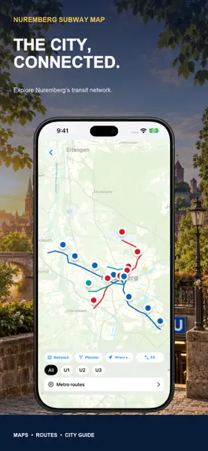
Discover Nuremberg, one station at a time. Nuremberg Subway Map brings an interactive U-Bahn map, station-to-station journey planning and practical city information together. Prepare a weekend visit, explore the Old Town or connect your sightseeing plans with the metro network. EXPLORE THE U-BAHN NETWORK Browse the color-coded U1, U2 and U3 lines on an interactive map. Find stations and see how Nuremberg and Fürth connect. Get an overview before leaving and choose stops that fit your day, from the city centre to parks, museums and shopping areas. PLAN BETWEEN STATIONS Choose your starting station and destination in the built-in route planner. Review the proposed journey, stops and connections. Stored network data supports offline planning for supported routes. Online maps and linked services require an internet connection. Calculated travel times are estimates, not live departures. KNOW YOUR LINES AND STOPS Browse available U-Bahn lines and their stations in order. Find a station by name and understand the route before heading to the platform. Useful for preparing a change of lines, planning an outing or visiting an unfamiliar part of the city. DISCOVER THE CITY AROUND YOUR STOP Add places to explore to your transport plans. Look for inspiration around the Old Town, markets, parks and museums. Browse food and shopping guidance, then keep journeys and daily plans together in the same app. Turn a station stop into a starting point for exploring Nuremberg. PREPARE YOUR AIRPORT JOURNEY Find guidance for Nuremberg Airport and the U2 connection when preparing an arrival or departure. Explore the airport board and travel tools, and open linked services where available. Check current information, availability and conditions with the provider before making a booking. U-Bahn journey planning does not cover every S-Bahn or regional rail service. PRACTICAL INFORMATION CLOSE BY Open city and transport information, reference prices and emergency tools. Prepare your stay and keep useful details nearby while exploring. Confirm current fares, ticket validity and travel conditions with the transport operator before setting out. FOR iPHONE AND iPAD Use your iPhone on the move or plan with more space on your iPad. Browse the network, read the city guide and prepare your next day in Nuremberg. Whether you are arriving for a short visit or exploring another district, start with a clear view of your journey. WHAT YOU CAN EXPLORE • An interactive map of Nuremberg’s U-Bahn network. • Journey planning between selected stations. • U1, U2 and U3 line and station information. • A city guide, food and shopping guidance. • Airport information and practical travel tools. • Use on iPhone and iPad. Nuremberg Subway Map is an independent travel app. Services, timetables, fares and access conditions may change. Check current departures, disruptions, ticket conditions and accessibility with the transport operator. The app does not promise live train positions or real-time traffic alerts. Some features or guide content may require watching an advertisement. Open the map, choose your station and discover Nuremberg.
What’s new
Version 4.1 · Updated October 19, 2026
This version brings together an interactive Nuremberg U-Bahn map, station-to-station journey planning, U1–U3 line information and a practical city guide. Explore food, shopping, airport connections and travel information. Supported routes use stored network data. Online maps and linked services require internet. Journey times are estimates.
App privacy
The developer, Yaroslav Mykolaienko, reported these privacy practices to Apple.
Data Used to Track You
The following data may be used to track you across apps and websites owned by other companies:
- Location: Coarse Location
Data Not Linked to You
The following data, which may be collected but is not linked to your identity, may be used for the following purposes:
- Location: Coarse Location
Used for: Other Purposes
Alternatives to Nuremberg Subway Map
Looking for apps like Nuremberg Subway Map? Here are 6 similar apps on the App Store. The highest rated is Cologne Travel Guide (4.9/5), and all 6 are free to download.
-
 Strasbourg Travel Guide
4.7
-
 Cologne Travel Guide
4.9
-
 Frankfurt Travel Guide .
4.6
-
 Munich Travel Guide .
4.8
-
 Germany Travel Guide Offline
4.5
-
 Official Dresden App
| App | Rating | Price | Last updated | Compare |
|---|---|---|---|---|
| Nuremberg Subway Map | – | Free | October 19, 2026 | |
| Strasbourg Travel Guide | 4.7 / 5 (25) | Free | Aug 26, 2026 | Compare |
| Cologne Travel Guide | 4.9 / 5 (32) | Free | Aug 21, 2026 | Compare |
| Frankfurt Travel Guide . | 4.6 / 5 (39) | Free | Sep 24, 2026 | Compare |
| Munich Travel Guide . | 4.8 / 5 (124) | Free | Sep 10, 2026 | Compare |
| Germany Travel Guide Offline | 4.5 / 5 (23) | Free | Oct 9, 2026 | Compare |
| Official Dresden App | – | Free | Oct 23, 2026 | Compare |