

Changsha Subway Map
Yaroslav Mykolaienko Navigation iPhoneiPadiPod touch
Changsha Subway Map is a free Navigation app for iPhone and iPad by Yaroslav Mykolaienko. Requires iOS 16.0. Updated October 28, 2026.
- Price
- Free
- on the App Store
- Size
- 18 MB
- Age 4+
- Updated
- Oct 28
- 2026 · v2.1
Screenshots


About Changsha Subway Map
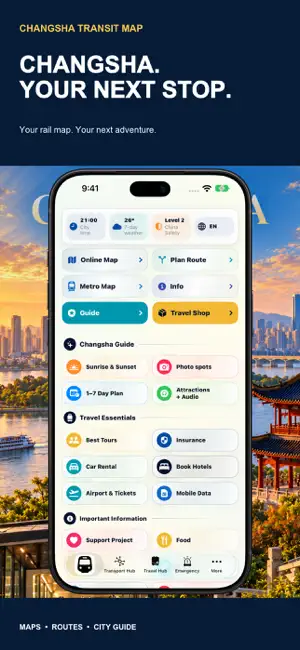
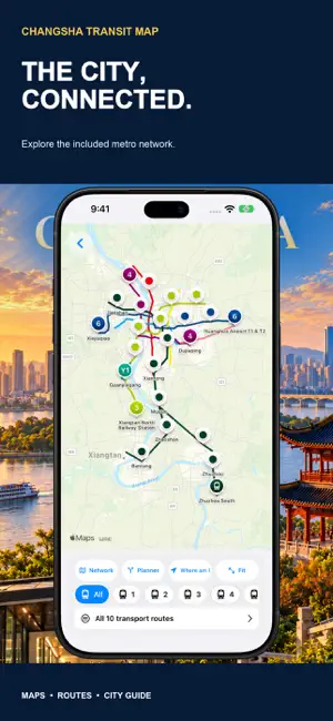
Discover Changsha, one station at a time. Changsha Subway Map brings a transport map, offline route planning and a practical city guide together on iPhone and iPad. Connect the places you want to see with nearby stations, understand your next transfer and build a day around the city’s neighborhoods and landmarks. EXPLORE THE INCLUDED METRO NETWORK Browse color-coded lines and stations on an interactive map. View the network, focus on a line and open station information to understand the places along your journey. Explore metro lines 1–6, the included intercity branches, Maglev airport connection and Y1 Yunba. Coverage follows the app’s stored network data; confirm current services and operating conditions with the relevant transport operator. PLAN ROUTES OFFLINE Choose your departure and destination stations, then review the suggested journey. See the stops, transfers and estimated travel time before setting off. The planner calculates supported routes using stored network data, so route calculation works offline. Open the route map for geographical context when an internet connection is available. Estimated times help you plan; they are not live departure times and may not include waiting or delays. KNOW YOUR NEXT STATION Open station details to learn about the included lines, connections and nearby places. Use station names as anchors for a day in Changsha, from Wuyi Square to Orange Isle and a different neighborhood. DISCOVER CHANGSHA BEYOND THE PLATFORM Explore the station-based city guide and find ideas for places to visit. Connect sightseeing with the transport network. Read about featured landmarks, understand nearby station access and choose what interests you. Check opening hours, reservations, ticket requirements and entry arrangements directly with each venue before visiting. FIND YOUR PHOTO SPOT Browse the photo guide for ideas around Changsha. Use the suggestions as a starting point, then check local access rules and conditions before your visit. MAKE A PLAN FOR YOUR VISIT Explore the visit planner with ideas for one to seven days. Use it to organize sightseeing and consider how the included places fit into your time in the city. Adapt your plans around arrival, departure, weather and the places you most want to see. Suggested plans are inspiration, not booked tours or guaranteed entry. KEEP PRACTICAL INFORMATION CLOSE Read transport information, shopping guidance and useful visitor tips in the app. Find emergency resources and links to travel services. Explore accommodation, tours and other options through external providers where offered. External bookings and purchases are handled by those providers under their own terms; availability and prices can change. MADE FOR iPHONE AND iPAD Carry your plan on iPhone or use the larger iPad display to study the network and read the guide. Move from the map to a route, then from a station to ideas for the surrounding area. Whether this is your first Changsha visit or a chance to explore a new district, transport and discovery stay together. FEATURES AT A GLANCE • Interactive map of the included rail network. • Offline route calculation between supported stations. • Stops, transfers and estimated journey times. • Line and station information. • Station-based city guide and nearby places. • Photo spot suggestions and a 1–7 day visit planner. • Transport, shopping and visitor resources. • Layouts for iPhone and iPad. Changsha Subway Map is an independent travel app, not an official transport operator app. Online maps and external services require internet access. Some features or content may require watching an advertisement. Check current fares, timetables, disruptions and accessibility with the operator before traveling. Open the map, choose your stations and discover Changsha at your own pace.
What’s new
Version 2.1 · Updated October 28, 2026
Explore Changsha with transport and city discovery in one place. This version brings together: • The included metro network and station information. • Offline route planning with stops, transfers and estimated journey times. • Station-based sightseeing guidance. • Photo spots and ideas for visits of one to seven days. • Practical transport, shopping and visitor information. Journey times are estimates, not live departures. Online maps and external services require internet access. Check current fares, service conditions and venue opening arrangements before traveling.
App privacy
The developer, Yaroslav Mykolaienko, reported these privacy practices to Apple.
Data Used to Track You
The following data may be used to track you across apps and websites owned by other companies:
- Usage Data: Advertising Data
Data Not Linked to You
The following data, which may be collected but is not linked to your identity, may be used for the following purposes:
- Usage Data: Advertising Data
Used for: Analytics
Alternatives to Changsha Subway Map
Looking for apps like Changsha Subway Map? Here are 6 similar apps on the App Store. The highest rated is MetroMan Changsha (5.0/5), and all 6 are free to download.
-
 MetroMan Changsha
5.0
-
 Chongqing Metro Map 重庆地铁
4.0
-
 Xi'an Metro Subway Map 西安地铁
3.0
-
 MetroMan Chengdu
4.9
-
 Explore Beijing
4.7
-
 Explore Shanghai
4.7
| App | Rating | Price | Last updated | Compare |
|---|---|---|---|---|
| Changsha Subway Map | – | Free | October 28, 2026 | |
| MetroMan Changsha | 5.0 / 5 (4) | Free | Oct 20, 2024 | Compare |
| Chongqing Metro Map 重庆地铁 | 4.0 / 5 (4) | Free | Sep 25, 2026 | Compare |
| Xi'an Metro Subway Map 西安地铁 | 3.0 / 5 (2) | Free | Sep 26, 2026 | Compare |
| MetroMan Chengdu | 4.9 / 5 (18) | Free | Oct 19, 2024 | Compare |
| Explore Beijing | 4.7 / 5 (496) | Free | Feb 18, 2026 | Compare |
| Explore Shanghai | 4.7 / 5 (1,323) | Free | Dec 27, 2025 | Compare |