

ON4Maps
MapGears inc. Navigation iPhoneiPadiPod touch
ON4Maps is a free Navigation app for iPhone and iPad by MapGears inc. Requires iOS 12.0. Updated July 16, 2026.
- Price
- Free
- on the App Store
- Size
- 485 MB
- Age 4+
- Updated
- Jul 16
- 2026 · v1.0.18
Screenshots


About ON4Maps
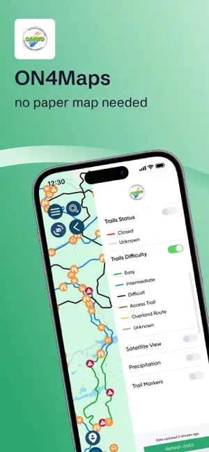
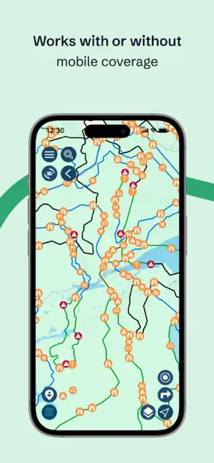
Get the best 4WD riding experience in Ontario with ON4Maps, OF4WD’s exclusive app for exploring and navigating trails across all of the province’s 4WD clubs. This isn’t just any 4WD trails app — as the official app of the Ontario Federation of 4 Wheel Drive , ON4Maps provides you with the most up-to-date trail information out there. Nothing else updates you faster or more accurately. Plus, with ON4Maps as your trail companion, you help build a stronger community of 4WD enthusiasts, clubs, and volunteers across Ontario — giving you even more reasons to enjoy the ride. Take ON4Maps for a spin, with all standard features — free to download and use. Unlock all features for less than your average coffee TOP FEATURES Works offline or online: Access OF4WD’s official trail maps, track your position and distances, spot POIs, and find nearby services like food, accommodation, and gas — even in remote areas. Receive trail updates with the most up-to-date trail status and conditions available anywhere. Personalize your ride: Plan itineraries, save favourite trails, record your journey, and share with friends. Stay connected securely: Share your location only with riders you select, and get notified about club events, exclusive offers, and 4WD community initiatives. Manage multiple 4WDs: Log different vehicles, keep notes, and track distances covered for each. GOOD TO KNOW • Using your smartphone’s GPS and location sharing continuously may drain your battery faster. PRO TIP: Maximize battery life by disabling these features when not needed.
What’s new
Version 1.0.18 · Updated July 16, 2026
Bug fixes and performance improvements
App privacy
The developer, MapGears inc., reported these privacy practices to Apple.
Data Used to Track You
The following data may be used to track you across apps and websites owned by other companies:
- Identifiers: User ID, Device ID
- Usage Data: Product Interaction
Data Linked to You
The following data, which may be collected and linked to your identity, may be used for the following purposes:
- Location: Precise Location
- Contact Info: Email Address, Name
- Contacts: Contacts
- User Content: Photos or Videos, Other User Content
- Identifiers: User ID, Device ID
Used for: App Functionality
Data Not Linked to You
The following data, which may be collected but is not linked to your identity, may be used for the following purposes:
- Identifiers: User ID, Device ID
- Usage Data: Product Interaction
- Diagnostics: Crash Data, Performance Data, Other Diagnostic Data
Used for: Analytics
Alternatives to ON4Maps
Looking for apps like ON4Maps? Here are 6 similar apps on the App Store. The highest rated is Ontario 511 (5.0/5), and all 6 are free to download.
-
 BRMB Maps by Backroad Maps
4.2
-
 HuntScout: Hunting Maps & More
4.7
-
 Marine Atlantic
1.0
-
 Blaise Transit
3.3
-
 Ontario 511
5.0
-
 407 ETR
4.5
| App | Rating | Price | Last updated | Compare |
|---|---|---|---|---|
| ON4Maps | – | Free | July 16, 2026 | |
| BRMB Maps by Backroad Maps | 4.2 / 5 (26) | Free | Oct 6, 2026 | Compare |
| HuntScout: Hunting Maps & More | 4.7 / 5 (29) | Free | Oct 23, 2026 | Compare |
| Marine Atlantic | 1.0 / 5 (1) | Free | Oct 23, 2026 | Compare |
| Blaise Transit | 3.3 / 5 (3) | Free | Oct 26, 2026 | Compare |
| Ontario 511 | 5.0 / 5 (1) | Free | Oct 26, 2026 | Compare |
| 407 ETR | 4.5 / 5 (212) | Free | Oct 27, 2026 | Compare |
Compare ON4Maps with the top alternatives: ratings, updates, ASO score and keyword gaps →