

FlyWeatherMETAR
Fabio Augusto De Carvalho Weather iPhoneiPadiPod touchApple Watch
FlyWeatherMETAR is a free Weather app for iPhone and iPad by Fabio Augusto De Carvalho. Requires iOS 17.0. Updated September 17, 2026.
- Price
- Free
- on the App Store
- Size
- 25 MB
- Age 4+
- Updated
- Sep 17
- 2026 · v4.1
Screenshots

About FlyWeatherMETAR
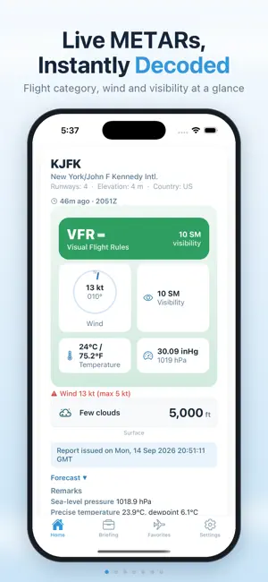
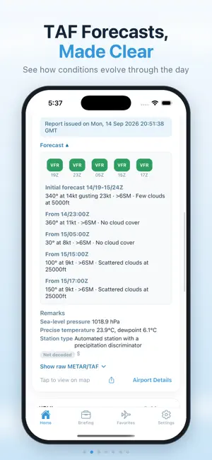
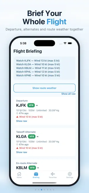
FlyWeatherMETAR puts real-time aviation weather in your pocket. Built for pilots, students, and aviation enthusiasts, it turns raw METAR and TAF data into a clean, at-a-glance briefing — and answers what the codes never do: is this within MY minimums? FLIGHT WEATHER, INSTANTLY Enter one ICAO code or several at once for an immediate flight-category read: VFR, MVFR, IFR, or LIFR, color-coded for a quick decision. Wind, visibility, temperature, altimeter, and cloud layers are laid out clearly, with the report timestamp so you know how current the data is. A trend marker shows whether conditions are improving, deteriorating, or steady, and remarks are decoded into plain language with hazards flagged. YOUR MINIMUMS, NOT JUST THE CATEGORY Define your own limits — visibility, ceiling, wind, gust, crosswind, tailwind, temperature, density altitude — as named profiles. Every airport you check is judged against the profile you're flying today and returns a plain go, caution, or no-go verdict, naming the limiting factor. PLAN THE WHOLE FLIGHT Build a briefing with a departure, a destination, and three alternates — takeoff, enroute, and destination — each with live conditions side by side. See the weather along the corridor between your airports as a green-to-red picture with the worst stretch marked, and read the forecast as a decoded TAF timeline instead of a wall of code. DIVERT OPTIONS WHEN PLANS CHANGE Nearby airports are ranked by how usable they are right now — your minimums verdict or flight category first, then distance — with bearing on every row. One tap routes you there and updates your briefing. SEE IT ON THE MAP Plot conditions instead of reading them: station markers colored by flight category, wind, and ceiling/visibility shading, each toggled on its own. Tap any station for its details. AIRPORT DETAILS AT A GLANCE ICAO, IATA, and FAA identifiers, field elevation, magnetic declination, tower and beacon status, and public/private use. A runway diagram shows every heading against the current wind and recommends the best runway, so crosswind and headwind components are obvious at a glance. Digital ATIS where published, plus a sunrise/sunset arc. FAVORITES, BUILT FOR HOW YOU FLY Save the airports you check most and see their flight category live on one dashboard. Set a home airport for one-tap access and tag airports by the role they play in your flight. Recently viewed airports stay readable offline, clearly marked as potentially stale. STAY AHEAD OF CHANGING CONDITIONS Turn on notifications for your home airport at a frequency that fits your flying, from hourly to once a day. Add alerts that fire on the conditions you care about, and get told when the forecast diverges from what was predicted. Home-screen widgets keep your favorites in view without opening the app. WHY PILOTS USE FLYWEATHERMETAR - Clean, color-coded flight categories (VFR/MVFR/IFR/LIFR) - Full METAR breakdown plus decoded TAF forecasts and remarks - Personal minimums profiles with go / caution / no-go verdicts - Flight briefings with a destination and three alternates - Route weather and nearby divert options, ranked by usability - Interactive weather map with toggleable layers - Runway/wind diagram with a recommended runway - Unlimited favorites with a home base, live badges, and widgets - Built-in Learn section with a METAR/TAF decode key - Fast, minimal interface designed for quick pre-flight checks FlyWeatherMETAR is powered by the Aviation Weather Center (aviationweather.gov / NOAA NWS), with airport data from OurAirports and Digital ATIS from atis.info. It is a reference tool, informational only, is not affiliated with any official aviation authority, and is not a substitute for an official weather briefing or your primary flight-planning source. Always consult approved sources such as your national aviation weather service before making any flight decisions. Download FlyWeatherMETAR and see airport weather the way pilots need it.
What’s new
Version 4.1 · Updated September 17, 2026
Flight briefing — plan a departure, a destination and up to three alternates, each with live conditions. Personal minimums — set your own limits once and see at a glance whether an airport is within them. Divert options — nearby airports ranked by how usable they are right now, with bearing, distance and a one-tap "Route here". Redesigned home — a decision hub that leads with what matters, plus a Favorites dashboard with live category badges. Map layers — category-colored station markers, wind and ceiling/visibility shading, each toggled on its own. Decoded forecasts — a TAF timeline, plain-language remarks and flagged hazards. ATIS and runway guidance — digital ATIS where it's published, and the best runway for the current wind. Route weather — conditions along the corridor between your airports, with alerts when the forecast shifts. Home-screen widgets — favorites and home-airport conditions at a glance. Faster and smoother — rebuilt on a new app framework, with the whole interface refreshed.
App privacy
The developer, Fabio Augusto De Carvalho, reported these privacy practices to Apple.
Data Not Collected
The developer does not collect any data from this app.
Alternatives to FlyWeatherMETAR
Looking for apps like FlyWeatherMETAR? Here are 6 similar apps on the App Store. The highest rated is Aviation Weather - RunwayBrief (5.0/5), and all 6 are free to download.
-
 Past Weather for Aviation
-
 Metano
-
 Aviation Weather - RunwayBrief
5.0
Aviation Weather - RunwayBrief
5.0
-
 CAVOK Weather
-
 AirportWX - METAR & TAF
3.0
AirportWX - METAR & TAF
3.0
-
 Weather.Co - GA Flight tools
5.0
Weather.Co - GA Flight tools
5.0
| App | Rating | Price | Last updated | Compare |
|---|---|---|---|---|
| FlyWeatherMETAR | – | Free | September 17, 2026 | |
| Past Weather for Aviation | – | Free | Sep 29, 2025 | Compare |
| Metano | – | Free | Sep 10, 2026 | Compare |
| Aviation Weather - RunwayBrief | 5.0 / 5 (1) | Free | Jan 10, 2026 | Compare |
| CAVOK Weather | – | Free | Jul 21, 2025 | Compare |
| AirportWX - METAR & TAF | 3.0 / 5 (1) | Free | Jan 26, 2026 | Compare |
| Weather.Co - GA Flight tools | 5.0 / 5 (5) | Free | Aug 23, 2026 | Compare |
Compare FlyWeatherMETAR with the top alternatives: ratings, updates, ASO score and keyword gaps →