

Spartan Forge: Hunt
Spartan Forge LLC Navigation iPhoneiPadiPod touch
Spartan Forge: Hunt is a free Navigation app for iPhone and iPad by Spartan Forge LLC. Rated 4.3/5 from 631 ratings. Requires iOS 16.6.
- Rating
- 4.3
- 631 ratings
- Price
- Free
- on the App Store
- Size
- 175 MB
- Age 4+
- Updated
- Sep 25
- 2026 · v1.19.23
Screenshots


About Spartan Forge: Hunt
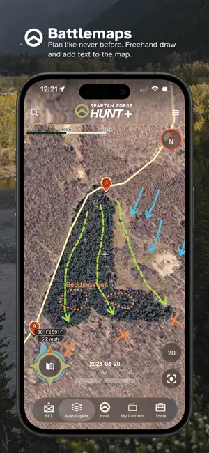
Plan smarter. Scout farther. Hunt better with Spartan Forge Hunt+. Spartan Forge combines advanced mapping, high-resolution UAV imagery, customizable LiDAR, AI-powered deer movement predictions, weather, property data, and field planning tools in one hunting platform — built for hunters, by hunters. See more of the ground before you step foot on it. Explore UAV and satellite imagery, LiDAR, terrain features, crop data, property boundaries, hunt units, and customizable map layers. Save presets and download maps for offline use. Turn scouting into a visual plan with BattleMap. Freehand draw on your map, add text, mark routes, visualize thermals, plan stalks, lay out deer drives, and build strategies around the terrain you hunt. Scout smarter with historical weather, wind data, sun exposure, terrain information, and Spartan Forge’s Deer Prediction model. KEY FEATURES • HIGH-RESOLUTION UAV & HISTORICAL IMAGERY Explore 5–15 cm UAV imagery with historical coverage dating back to 2016, plus historical satellite imagery through Sat-1. See trees, habitat changes, access routes, timber cuts, and other details traditional satellite maps may miss. • CUSTOMIZABLE LIDAR See terrain beneath the canopy with high-resolution LiDAR. Identify benches, drainages, game trails, old logging roads, subtle terrain changes, rock features, and more. Customize LiDAR settings to emphasize what matters most. • BATTLEMAP Draw freehand on the map, add text, create arrows, and customize line size, color, and style. Map access routes, thermals, deer drives, stalks, decoy spreads, stand approaches, and more. Save and access BattleMaps on mobile and web. • DEER PREDICTION Use Spartan Forge’s deer movement prediction model, built using GPS-collared deer data and environmental conditions from across the U.S., to better understand potential deer movement and activity. • HISTORICAL WIND & WEATHER Research historical wind and weather conditions, view forecasts, and use weather information directly from your map. • ADVANCED MAP CUSTOMIZATION Combine imagery, LiDAR, property information, terrain layers, crop data, weather, sun exposure, and other overlays. Save presets for fast switching in the field. • OFFLINE MAPS Download supported satellite, topo, hybrid, and other maps before your hunt so critical information remains available beyond cell service. • PRIVATE & PUBLIC LAND DATA View property boundaries and ownership information, identify public hunting ground, mark access, and stay informed when saved parcels change ownership. • PIN SHARING & BLUE FORCE TRACKER Share individual pins with hunting partners or use Blue Force Tracker to automatically share pins within a defined area. • EAGLEEYE (Web Only) View terrain and imagery from side-angle perspectives to better understand ridges, valleys, and access routes. • CYBERSCOUT AI (Web Only) Ask CyberScout hunting-related questions and get AI-powered guidance for scouting, planning, gear, and more. • MOBILE + DESKTOP SYNC Plan from your desktop, then take your information into the field. Maps, pins, BattleMaps, and other content stay synced across supported devices. MEMBERSHIP OPTIONS ► FREE Get started with default maps, weather, basic property ownership, pins, and essential planning tools. ► PAID MEMBERSHIP — ONE PRICE, ALL STATES Choose a monthly or yearly membership and unlock Spartan Forge Hunt+ across every state, including advanced mapping, property boundaries, Deer Prediction, CyberScout, UAV and historical imagery, LiDAR, BattleMap, Blue Force Tracker, offline maps, and more. One platform. More information. Better decisions in the field. Terms of Use: https://spartanforge.ai/pages/terms-of-service Questions or feedback? Contact [email protected]
Ratings & reviews
4.3
631 ratings
What’s new
Version 1.19.23 · Updated September 25, 2026
Updated Tracks Interface Snap-To Measurements Liquid Glass Support
App privacy
The developer, Spartan Forge LLC, reported these privacy practices to Apple.
Data Linked to You
The following data, which may be collected and linked to your identity, may be used for the following purposes:
- Location: Precise Location, Coarse Location
- Contact Info: Email Address, Name
- User Content: Photos or Videos, Customer Support
Used for: Developer’s Advertising or Marketing, App Functionality, Other Purposes
Alternatives to Spartan Forge: Hunt
Looking for apps like Spartan Forge: Hunt? Here are 6 similar apps on the App Store. The highest rated is GOHUNT: Research & Maps (4.8/5), and all 6 are free to download.
-
 GOHUNT: Research & Maps
4.8
GOHUNT: Research & Maps
4.8
-
 Deer Hunters MoonGuide 3.0
4.7
Deer Hunters MoonGuide 3.0
4.7
-
 Track N Trail - Hunting & Maps
4.8
Track N Trail - Hunting & Maps
4.8
-
 HuntWise: A Better Hunting App
4.7
HuntWise: A Better Hunting App
4.7
-
 BaseMap: 3D Hunting Maps & GPS
4.6
BaseMap: 3D Hunting Maps & GPS
4.6
-
 onX Fish: GPS Fishing Maps
4.6
onX Fish: GPS Fishing Maps
4.6
| App | Rating | Price | Last updated |
|---|---|---|---|
| Spartan Forge: Hunt | 4.3 / 5 (631 ratings) | Free | September 25, 2026 |
| GOHUNT: Research & Maps | 4.8 / 5 (8,540) | Free | Sep 21, 2026 |
| Deer Hunters MoonGuide 3.0 | 4.7 / 5 (998) | Free | Sep 9, 2026 |
| Track N Trail - Hunting & Maps | 4.8 / 5 (2,394) | Free | Sep 18, 2026 |
| HuntWise: A Better Hunting App | 4.7 / 5 (68,611) | Free | Sep 25, 2026 |
| BaseMap: 3D Hunting Maps & GPS | 4.6 / 5 (9,182) | Free | Sep 21, 2026 |
| onX Fish: GPS Fishing Maps | 4.6 / 5 (1,756) | Free | Sep 24, 2026 |