

Zoom Earth - Weather Forecast
Neave Interactive Weather iPhoneiPadiPod touch
Zoom Earth - Weather Forecast is a free Weather app for iPhone and iPad by Neave Interactive. Rated 4.8/5 from 38,452 ratings. Requires iOS 15.5.
- Rating
- 4.8
- 38.4K ratings
- Price
- Free
- on the App Store
- Size
- 54 MB
- Age 4+
- Updated
- Sep 15
- 2026 · v6.2.1
Screenshots


About Zoom Earth - Weather Forecast
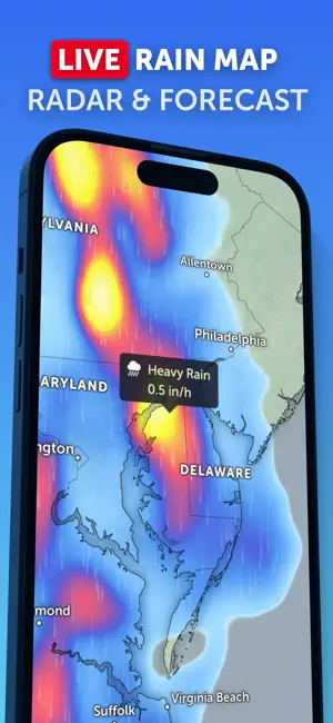
INTERACTIVE WEATHER MAP Zoom Earth is an interactive weather map of the world and a real-time hurricane tracker. Explore the current weather and see forecasts for your location through interactive weather maps of rain, wind, temperature, pressure, and more. With Zoom Earth, you can track the development of hurricanes, storms, and severe weather, monitor wildfires and smoke, and stay aware of the latest conditions by viewing satellite imagery updated in near real‑time. SATELLITE IMAGERY Zoom Earth shows weather maps with near real-time satellite imagery. Live satellite images from NOAA GOES, JMA Himawari, and EUMETSAT Meteosat geostationary satellites are updated every 10 minutes. HD satellite images are updated twice a day from NASA polar-orbiting satellites Aqua and Terra. RAIN RADAR & NOWCAST Stay ahead of the storm with our weather radar map, which shows rain and snow detected by ground-based Doppler radar in real-time, and provides an instant short-term weather forecast with radar nowcasting. WEATHER FORECAST MAPS Explore beautiful, interactive visualizations of the weather with our stunning global forecast maps. Our maps are continually updated with the latest weather forecast model data from DWD ICON and NOAA/NCEP/NWS GFS. Weather forecast maps include: Precipitation Forecast - Rain, snow, and cloud cover, all in one map. Wind Speed Forecast - Average speed and direction of surface winds. Wind Gusts Forecast - Maximum speed of sudden bursts of wind. Temperature Forecast - Air temperatures at 2 meters (6 feet) above the ground. “Feels Like” Temperature Forecast - Perceived temperatures, also known as apparent temperature or heat index. Relative Humidity Forecast - How air moisture compares to temperature. Dew Point Temperature Forecast - How dry or humid the air feels, and the point at which condensation occurs. Wet-Bulb Temperature Forecast - Heat stress levels. Atmospheric Pressure Forecast - The average atmospheric pressure at sea level. Low-pressure areas often bring cloudy and windy weather. High-pressure areas are associated with clear skies and lighter winds. HURRICANE TRACKING Follow hurricanes from development to category 5 in real-time with our best-in-class tropical tracking system. Information is clear and easy to understand. Our hurricane tracking weather maps are updated using the very latest data from NHC, JTWC, NRL, and IBTrACS. WILDFIRE TRACKING Monitor wildfires with our active fires and heat spots overlay, which shows points of very high temperature detected by satellite. Detections are updated daily with data from NASA FIRMS. Use in conjunction with our GeoColor satellite imagery to see the movement of wildfire smoke and monitor fire weather in near real-time. CUSTOMIZATION Adjust temperature units, wind units, time zone, animation styles, and many more features with our comprehensive settings. ZOOM EARTH PRO More features are available through auto-renewable subscriptions. Payment will be charged to your App Store account at the confirmation of purchase. The subscription will automatically renew at the end of each billing period and be charged within 24 hours, unless auto-renew is turned off at least 24 hours before the end of the current period. For further information, please read our Terms of Service. LEGAL Terms of Service: https://zoom.earth/legal/terms/ Privacy Policy: https://zoom.earth/legal/privacy/
Ratings & reviews
4.8
38.4K ratings
What’s new
Version 6.2.1 · Updated September 15, 2026
- Coordinate Grid Overlay and Pressure Values on Isolines. Read coordinates and pressure at a glance. - Swipeable Weather Panel. Switch easily between daily and hourly summaries. - Smoother Satellite Imagery. Improved loading as you explore the map. - Search for Saved Locations. Your saved locations now appear in the search results. - More Improvements. Updated map labels, an improved wet-bulb temperature map, European Portuguese support, and other fixes.
App privacy
The developer, Neave Interactive, reported these privacy practices to Apple.
Data Linked to You
The following data, which may be collected and linked to your identity, may be used for the following purposes:
- Contact Info: Email Address, Name
- Identifiers: User ID
Used for: App Functionality
Data Not Linked to You
The following data, which may be collected but is not linked to your identity, may be used for the following purposes:
- Location: Coarse Location, Precise Location
- Identifiers: Device ID
- Usage Data: Product Interaction, Advertising Data
- Diagnostics: Crash Data, Performance Data
- Purchases: Purchase History
Used for: Third-Party Advertising, Analytics, App Functionality
Alternatives to Zoom Earth - Weather Forecast
Looking for apps like Zoom Earth - Weather Forecast? Here are 6 similar apps on the App Store. The highest rated is Ventusky: Weather Forecast (4.8/5), and all 6 are free to download.
-
 Ventusky: Weather Forecast
4.8
Ventusky: Weather Forecast
4.8
-
 National Hurricane Center Data
4.8
National Hurricane Center Data
4.8
-
 Windfinder: Wind & Weather map
4.8
Windfinder: Wind & Weather map
4.8
-
 Windy.com
4.8
Windy.com
4.8
-
 PredictWind — Marine Forecasts
4.8
PredictWind — Marine Forecasts
4.8
-
 Tides Near Me
4.8
Tides Near Me
4.8
| App | Rating | Price | Last updated |
|---|---|---|---|
| Zoom Earth - Weather Forecast | 4.8 / 5 (38,452 ratings) | Free | September 15, 2026 |
| Ventusky: Weather Forecast | 4.8 / 5 (35,270) | Free | Sep 17, 2026 |
| National Hurricane Center Data | 4.8 / 5 (75,407) | Free | Sep 24, 2026 |
| Windfinder: Wind & Weather map | 4.8 / 5 (61,829) | Free | Sep 16, 2026 |
| Windy.com | 4.8 / 5 (79,283) | Free | Sep 14, 2026 |
| PredictWind — Marine Forecasts | 4.8 / 5 (32,802) | Free | Sep 24, 2026 |
| Tides Near Me | 4.8 / 5 (162,130) | Free | Sep 9, 2026 |